The Canaan Mountain Backcountry sits on a similar high plateau as the Dolly Sods, sharing the same cool, moist climate and northern ecosystem of wetlands and conifers. Numerous trails crisscross the highlands with a wide range of back country campsites and shelters, providing a variety of options for overnight and multiday hikes. The adjacent Blackwater Falls State Park provides additional lodging choices with rental cabins, RV lots, and campgrounds available. The distinctive tea- or cola-colored ‘black water’ of the local streams and falls are due to tannins leached from years of fallen spruce and hemlock needles that cover the plateau’s slopes.
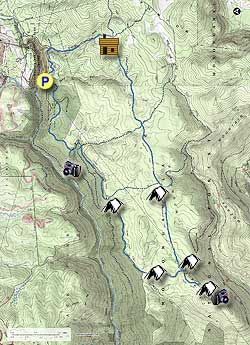
This overnight loop visits two of the most scenic views in the backcountry – Table Rock and Lindy Point Overlook – and passes through beautiful peat bogs, stands of conifers, fern-filled glades, and rhododendron tunnels. Plenty of campsites are available to choose from, with several cross-trails and side loops providing the opportunity to shorten or extend the hike if desired. Trail traffic falls off considerably once over the State Park boundary, with only the occasional fellow hiker or mountain biker sharing the trail. The return leg uses an unmaintained section of the Canaan Loop forest road which no longer sees regular vehicle use.
Note: Like Dolly Sods, much of the Canaan Mountain Backcountry trails feature boggy or waterlogged sections that must be traversed. Plan ahead and bring gaiters and/or waterproof footwear to keep dry.
There are no fees for overnight parking at Blackwater Falls Lodge, but be sure to visit the Lodge reception desk to let them know your vehicle details, hike itinerary, and emergency contact info. Alternatively, there is limited parking space at a primitive camping site on the Canaan Loop Road just past Lindy Overlook. Reaching this spot requires fording Lindy Run and is only recommended for high clearance and/or 4-wheel drive vehicles. No overnight parking is allowed at the Lindy Overlook parking lot.
Day One – 9.4 miles
- Mile 0.0 – From the Blackwater Falls Lodge parking lot, leave by the eastern lot entrance and cross Blackwater Lodge Road to join Yellow Birch Trail. Yellow blazes mark the trail as it turns south-eastward, at one point passing through a small boulder pile.
- Mile 0.9 – The trail descends as it crosses a driveway and joins with the Allegheny Trail. Cross a small wooden footbridge over Engine Run and come to a signed intersection. Turn right onto the Allegheny/Davis Trail as it runs south along Engine Run. Yellow blazes, blue placards, and reflective “Heart of the Highlands Trail System” signs are used interchangeably to mark the route.
- Mile 1.2 – The trail merges with a former disused section of the Davis Trail before crossing the State Park boundary into the Monongahela National Forest and Canaan Mountain Backcountry area. Another wooden footbridge crosses over Engine Run, and after half a mile the trail turns southwest and begins to move away from the stream.
- Mile 2.4 – Pass a shelter and campsite set back from the trail on the right before reaching an intersection with Plantation Trail. The straight and left trails (south and east) both continue for approximately one mile before reaching the gravel Canaan Loop Road which rings the plateau. Turn right to follow the yellow-blazed Plantation Trail as it runs westward along the plateau’s crest, bisecting the Backcountry area. Soon after joining Plantation Trail, pass a small open peat bog to the left. The plateau’s rolling terrain is poorly drained, resulting in numerous boggy, washed out, and partially flooded sections of trail. In some places this has been partially alleviated by logs, stones, or other drainage measures.
- Mile 3.5 – Pass through an intersection with Pointy Knob Trail/Fire Trail No. 6 to the left. This trail makes a 7.8 mile loop to the south through higher elevations and past several falls on the south fork of Red Run, before returning to Plantation Trail via the Railroad Grade Trail.
- Mile 4.6 – The trail travels through rocky terrain shortly before passing through an intersection with Lindy Run Trail. To the right, Lindy Run Trail runs north 1.5 miles before meeting with Canaan Loop Road near Lindy Point Overlook. This northern section of trail is no longer maintained by the Forest Service but has been kept clear by volunteer hikers and mountain bikers. To the left, Lindy Run Trail runs southwest approximately one mile before reaching the southern portion of Canaan Loop Road. Past this point the trail is no longer blazed but the route is easily visible. Continue straight along Plantation Trail. Just past the intersection there is a small campsite with fire pit, located in a fern-filled clearing close to two nearby streams.
- Mile 6.0 – The Railroad Grade Trail diagonally crosses Plantation Trail at a partially marked intersection. Blue placards and streamers have been placed by bikers to mark the RR Trail turnoff, which follows an old logging railroad grade. The northern section to the right is decommissioned but still used unofficially by mountain bikers to connect with the northern Canaan Loop Road. A shelter and campsite are located a half mile down the southern section to the left. Keep right to stay on the Plantation Trail.
- Mile 7.9 – Pass between another peat bog and sandstone outcropping shortly before Plantation Trail exits onto the Canaan Loop Road. Turn left and follow the road 75 yards to reach a small parking area and the Table Rock trailhead. There is a stream and roadside campsite another 250 yards further down the road – this is the closest water source to the dry Table Rock campsite, so if you plan to overnight there fill your canteens here before going further.
- Mile 9.4 – Proceed up Table Rock Trail as it climbs towards the southwestern tip of the plateau. A dry campsite is located 80 yards from the Table Rock overlook. The overlook itself provides an incredible view of Mozark Mountain to the south and Red Run as it descends from the plateau towards the Otter Creek Wilderness to the southwest. Stick around for a dramatic sunset before settling in for the night or hiking back to the alternate campsite on Canaan Loop Road.
Day Two – 8.6 miles
- Mile 0.0 – Wake up and enjoy the sunrise over breakfast before breaking camp.
- Mile 1.0 – Return to Canaan Loop Road via Table Rock Trail and turn left to follow the road clockwise around the edge of the plateau.
- Mile 1.8 – Pass a peat bog on the right and Mountain View Trail on the left before coming across two campsites on either side of a stream crossing. From this point forward the Canaan Loop Road is no longer maintained. Traffic is rare and limited to high-clearance 4-wheel drive vehicles due to numerous potholes and occasional washouts. The road steadily descends as the land to the left falls away into Blackwater River Gorge.
- Mile 4.0 – The road passes through several stands of red spruce along the southern lip of the gorge, including an excellent large campsite, before intersecting with the northern exit of the Railroad Grade Trail. The intersection is only partially marked with streamers tied to branches and a few faded blue blazes, but the elevated railroad grade is readily distinguishable as it meets the road diagonally from the right. A small campsite is located opposite the intersection in a grassy clearing.
- Mile 5.5 – The unmarked Lindy Run Trail emerges from the right near the alternate primitive parking spot before the road dips to ford Lindy Run. Another small campsite is located just across the ford where the road makes an immediate right-hand turn.
- Mile 5.7 – The road becomes paved at the Lindy Point Overlook parking lot. Turn left to follow the red blazed Lindy Point Trail.
- Mile 6.1 – Reach the rock outcropping of Lindy Point, which hangs 900 feet over the valley floor below with dramatic views up and down Blackwater River Gorge. Be careful if leaving the wooden platform to walk on the rocks themselves, as the outcropping is split by numerous deep clefts and chasms.
- Mile 7.4 – After enjoying the view, return along Lindy Point Trail to the parking lot and turn left to continue following the now paved Canaan Loop Road as it enters Blackwater Falls State Park. Eventually come to the Sled Run / Ski Touring Center on the right. Circle around back of the building to find the entrance to Shay Trace Trail to the left at the base of the sledding slope.
- Mile 7.9 – Follow the blue-blazed Shay Trace Trail uphill, crossing an intersection with the yellow-blazed Cherry Lane Trail before passing through a set of rental cabins. Past the cabins the trail descends through a storm-battered hemlock grove, crossing two further intersections with red-blazed Red Spruce Trail and orange-blazed Balanced Rock Trail. There is a choice to take a half mile detour to the left along Balanced Rock Trail, which passes by another scenic overlook of the Gorge and the picturesque Elakala Falls before ending at Blackwater Falls Lodge.
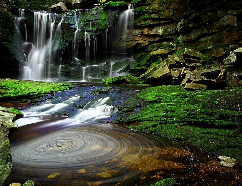
- Mile 8.6 – Shay Trace Trail crosses a wooden footbridge over Shay Run before exiting onto Blackwater Lodge Road. Turn right and follow the road 125 yards to reach the Blackwater Falls Lodge parking lot where you started from. On your way out of the State Park feel free to stop and see the namesake Blackwater Falls from one of the roadside overlooks.


