Campbell Falls Trail at Campbell Falls State Park in Norfolk, Connecticut is a moderate 0.3-mile out-and-back hike that leads to the 60-foot tall waterfall, Campbell Falls.
Two State Hike
This trail crosses the Massachusetts and Connecticut border and the parking lot is also split between both states, so you'll hike in two different states to view Campbell Falls. Campbell Falls lies within Massachusetts despite the State of Connecticut's land-use rights to claim the state park boundaries. Hikers will also find two stone boundary markers for MA and CT at the parking lot and along the trail -- both from a 1906 survey.
Hike Description
This hike begins at the main parking lot for Campbell Falls, located at the parking coordinates provided along Campbell Falls Road and follows the trail that leads into the woods. There are "falls -->" signs that show the way to the waterfall, however it's pretty easy -- simply hike down the main trail as it leads to Ginger Creek. Along the way is another CT/MA border crossing where you'll once again hike from Connecticut back into Massachusetts.
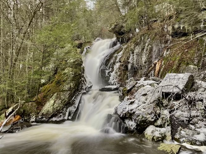
Campbell Falls, 60-feet tall - Mile 0.15
At the bottom of the hill and at the end of the trail, hikers will find the 60-foot tall Campbell Falls as it roars down the cliff's bedrock. The waterfall shoots into a canyon-like rock gully in its upper tier before diverting water to a second tier below. After a heavy rainfall this waterfall is roaring and quite the sight for hikers.
The hike back is simple, but all uphill back to parking. The difficulty should be easy for most hikers but might be moderate for some, hence the moderate difficulty.
Parking
Hikers will find a parking lot at the coordinates provided, located along Campbell Falls Road right at the border of Massachusetts and Connecticut. The lot is large enough to fit just under a dozen vehicles, max.
Pets
Dogs are allowed only if leashed and must be cleaned up after.
Two State Hike
This trail crosses the Massachusetts and Connecticut border and the parking lot is also split between both states, so you'll hike in two different states to view Campbell Falls. Campbell Falls lies within Massachusetts despite the State of Connecticut's land-use rights to claim the state park boundaries. Hikers will also find two stone boundary markers for MA and CT at the parking lot and along the trail -- both from a 1906 survey.
Hike Description
This hike begins at the main parking lot for Campbell Falls, located at the parking coordinates provided along Campbell Falls Road and follows the trail that leads into the woods. There are "falls -->" signs that show the way to the waterfall, however it's pretty easy -- simply hike down the main trail as it leads to Ginger Creek. Along the way is another CT/MA border crossing where you'll once again hike from Connecticut back into Massachusetts.
Campbell Falls, 60-feet tall - Mile 0.15
At the bottom of the hill and at the end of the trail, hikers will find the 60-foot tall Campbell Falls as it roars down the cliff's bedrock. The waterfall shoots into a canyon-like rock gully in its upper tier before diverting water to a second tier below. After a heavy rainfall this waterfall is roaring and quite the sight for hikers.
The hike back is simple, but all uphill back to parking. The difficulty should be easy for most hikers but might be moderate for some, hence the moderate difficulty.
Parking
Hikers will find a parking lot at the coordinates provided, located along Campbell Falls Road right at the border of Massachusetts and Connecticut. The lot is large enough to fit just under a dozen vehicles, max.
Pets
Dogs are allowed only if leashed and must be cleaned up after.