Loading...

WINTER SALE! 50% OFF Supporter Accounts — now through January 31st. Learn More.

Camp Hoover Hike

Camp Hoover, also known as Rapidan Camp, is a scenic and historic hike that passes the retreat of former President Herbert Hoover, and First Lady Lou Henry Hoover. The circuit is a moderate hike and passes Big Rock Falls, which is a small pool and stream cascade where the trail crosses Mill Prong.

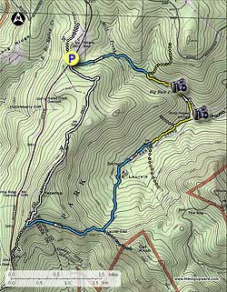
From the parking area at Milam Gap, cross Skyline Drive and follow the white blazed Appalachian Trail (AT) for 100 yards to the intersection of the blue blazed Mill Prong Trail. Turn left downhill on the blue blazed trail as it descends into the valley, then in 0.5 miles crosses Mill Prong for the first time. Continue to follow the trail for another 0.4 miles where it crosses another small creek that feeds Mill Prong, and in 100 yards arrive at the intersection of a horse trail that leads to the Rapidan Fire Road.

Turn right downhill on the now yellow blazed Mill Prong Trail, from this point to Camp Hoover, backcountry camping is not allowed. In 0.3 miles from the previous intersection, the yellow blazed Mill Prong Trail will cross Mill Prong and pass Big Rock Falls. Continue downward on the trail for another 0.4 miles where the Mill Prong Trail ends at Camp Hoover. Turn right on the access road, then immediately left down the footpath passing "The Creel" house. "The Creel" was occupied by two of President Hoover's chief aids. Larry Richey, a former F.B.I. agent assigned to guard the President who also acted as his personal secretary; and Joel T. Boone Jr., the Presidents personal physician.

60 yards past "The Creel" house is the presidential main quarters known as the "Brown House". The rear deck on the "Brown House" is a great place to enjoy the same view former President Hoover and world dignitaries enjoyed back in the 1920's. When he left office, Herbert Hoover, and his wife Lou Henry Hoover, donated the land to the government to become part of the newly created Shenandoah National Park.

From the "Brown House" continue on the yellow blazed Laurel Prong Trail, that starts at the Camp Hoover turn around. The yellow blazed trail will initially follow an old forestry road for the first 0.4 miles, then the forestry road veers right uphill. Remain left on the narrower yellow blazed trail for another 0.5 miles to the intersection of the yellow blazed Fork Mountain Trail. Stay straight on the now blue blazed Laurel Prong Trail for 0.4 miles, then pass a spring and only good camp site on the hike. Follow the trail uphill for another 0.8 miles to the saddle, and junction of the Cat Knob Trail.

Turn right on on the blue blazed Cat Knob Trail as it continues uphill for 1.1 miles to the intersection of the white blazed Appalachian Trail (AT). Turn right uphill on the AT crossing over the hike high point, and Hazeltop Mountain, in 0.4 miles. From the high point, the AT now heads downward for the remaining 2.3 miles back to Skyline Drive, and the Milam Gap parking area.
Explore 86 trails near Madison County, VA

Know Before You Go

  • The Camp Hoover/Rapidan Camp hike is a 7-mile moderate loop in Shenandoah National Park, offering scenic views and historical significance as the former retreat of President Herbert Hoover.
  • The trail includes notable landmarks such as Big Rock Falls, "The Creel" house, and the "Brown House," providing opportunities to appreciate both natural beauty and presidential history.
  • The route involves following a combination of blazed trails (white AT, blue Mill Prong/Laurel Prong/Cat Knob, yellow Mill Prong/Fork Mountain) with specific distances and directions, requiring attention to trail markers for navigation.
Interactive topographic map for Camp Hoover Hike located in Madison County, VA. Click the "View Map" button to load GPS coordinates and trail markers.
Get directions
Distance
7.0 mi
Difficulty
Moderate
Type
Loop
Est. Time
3.5 hrs
Elev. Gain
1,360'
Rating
4.0
Added
March 18, 2025
Updated
April 05, 2025

Weather Forecast

Loading...
Total Change
1,297'
Ascent
1,360'
Descent
1,358'
Loading...

Download the GPX Data for Offline Use

Supporters get exclusive access to download trail routes to the MyHikes app for offline use. Stay prepared on your adventure, even without an internet connection! Become a Supporter today to unlock this feature and hike with confidence.

Download Camp Hoover Hike GPX Data to the MyHikes Mobile App

Features

Vista / Lookout Point
Dogs
Waterfalls
Mountain Summit
Camping
Water Source
Appalachian Trail logo Appalachian Trail hike

Points of interest

  1. Parking

    38.500388, -78.44556
  2. Main Trailhead

    38.499516, -78.445687

Safety information

For your own safety: plan ahead, let someone know where you'll be, and hike at your own risk.

Hazards

Snakes (Rattlesnakes, Copperheads, others)
Poison Ivy or Poison Oak

Markers

Blaze Color

White

Availability

All seasons

Surface type

Dirt

Trip Reports (Reviews)

Rated 3.97 out of 5 based on 33 ratings.

Ready to help fellow hikers? Add a trip report to share your experience and provide valuable insights for other hikers!

By: Bret
7.0 miles / 11.3 km
August 22, 2017
I had hiked to Camp Hoover from Milam Gap as an out & back in June but wanted to do the full loop. The hike down Mill Prong is enjoyable with the stream close he majority of the decent. The first stream crossing is my favorite with water flowing around a tree surround by moss covered rocks. It has a surreal feel and I expect gnomes to peak out around the rocks. Big Rock falls while not large is a relaxing place to take a short break before continuing to Camp Hoover. The day I stopped at the camp the gentleman at he camp was very knowledgable about the history of the camp I stayed longer then planned but was worth the time. After the camp I headed up Laurel Prong which is a lovely hike crossing many streams and springs. Continuing on to the AT I came across and overlook just past the summit of Hazeltop Mtn. The view was reminded why I enjoy the hike and was the perfect place to recharge while enjoying a snack. I only encountered a few hikers, mostly on the AT. Overall great solitude, some nice streams and a new favorite in Shenandoah.
Legacy Review
By: Steve
7.0 miles / 11.3 km
October 25, 2016
This is one of the more picturesque hikes on this web site. A volunteer was at Camp Hoover giving an interesting presentation. The other reviews cover main points well. My main point in this review is to note that, in the description, I think the fifth paragraph, starting “From the ‘Brown House’” may be incorrect, confusing the yellow and blue blazed trails. I think this can be verified from the map. I suggest a rewritten version as follows (if I am wrong please correct me): “From the ‘Brown House’ continue on the yellow blazed Laurel Prong Trail, that starts at the Camp Hoover turn around. The yellow blazed trail will initially follow an old forestry road for the first 0.4 miles to an intersection where the forestry road veers left downhill. Turn right on the narrower blue blazed Laurel Prong Trail for 0.4 miles, then pass a spring and only good camp site on the hike. Follow the trail uphill for another 0.8 miles to the saddle, and junction of the Cat Knob Trail.”
Legacy Review
By: EllieMierz
7.0 miles / 11.3 km
September 19, 2015
This was my first overnight backcountry camping experience and it was a great loop to do it on! We started on Saturday at 9:30 am from Milam Gap parking, and went the Laurel Prong trail first instead of the Mill Prong. I would recommend this route. The AT stretch was not strenuous with a lovely lookout. It was not busy. We set up camp at about 1pm on the Fork Mountain Trail next to the stream where there was a perfect spot for a small tent and good places to hang our bear bag. Once we set up camp, we headed the .5 miles to Camp Hoover at 4 pm, and were able to speak with the rangers and get a tour of Hoovers getaway. It was a lovely and informative tour that changed my mind about Herbert Hoover altogether! Seemed like a very kind man. It was nice exploring the camp in the dwindling daylight. We awoke on Sunday morning and set off at 9 am. We allowed ourselves 2 hours to get back to Milam Gap via Mill Prong (2.8 miles) since it was entirely all steep uphill. About .2 miles from Big Rock Falls, we spotted a very large black bear 20 ft. to the left of the trail staring at us on its hind legs. We made lots of noise and blew our whistles and eventually it turned and ran away. Needless to say, we were back at the parking lot by 10 am, practically running the rest of the uphill. All in all, it was an extremely enjoyable trip. I loved the solitude of the camp, and the quietness of the entire hike. I would definitely do it again as an overnight or a day hike!!!
Legacy Review
No community routes found. To add your own hike as a Community Route for this Trail guide, leave a Trip Report with an attached GPX file.

Popular categories

Scenic mountain view representing vista trails
Vista trails
Scenic gorge of cascades representing waterfall trails
Waterfall hikes
Rugged mountain terrain representing summit trails
Summit trails
Scenic mountain view representing dog-friendly trails
Dog-friendly
Scenic campsite with a view representing camping trails
Camping trails
Appalachian Trail logo representing A.T. hikes
A.T. hikes

You May Also Like

25 Best Day Hikes in North Carolina - Discover the top 25 best day hikes in North Carolina, from breathtaking waterfalls to mountain peaks. Explore hidden gems, scenic views, and trails suitable for all skill levels, perfect for your next outdoor adventure.
Explore

25 Best Day Hikes in North Carolina

Discover the top 25 best day hikes in North Carolina, from breathtaking waterfalls to mountain peaks. Explore hidden gems, scenic views, and trails suitable for all skill levels, perfect for your next outdoor adventure.

Read
🍪 We use cookies to learn about site usage and to serve map tiles. You may block cookies manually in the browser. By continuing you agree. Learn more