Loading...

WINTER SALE! 50% OFF Supporter Accounts — now through January 31st. Learn More.

Calf Mountain Hike

This is the furthest southern hike that can be done in Shenandoah National Park before entering the Blue Ridge Parkway. The Appalachian Trail follows Skyline Drive on the thinnest part of SNP, ever wonder why it is not very wide at this point? Checkout this blog from our friend and fellow hiker Jeff, great job on the history of that last section of SNP.

We did this as a 2 day backpack, camping at the Calf Mountain Shelter, roughly 8 miles out and 8 miles back. The views from Bear Den Mountain, Beagle Gap, and Little Calf Mountain make this a hike you will want to do.

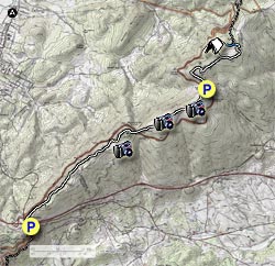
  • Mile 0.0 – The hike begins at the parking area in between Route 250 and I-64 just before the entrance to Shenandoah NP. Head north on the Appalachian Trail (NT), crossing over I-64 and in about 350 yards the Appalachian Trail will bear to the right.
  • Mile 2.6 – Continue your climb on the AT over Scott Mountain, pass through 2 gates and 3 intersections, be careful and follow the white blazes at the intersections and in 3.1 miles reach an overlook looking west to Waynesboro.
  • Mile 3.1 – After a steep descent you will reach McCormick Gap and then cross Skyline Drive. Note: On the return trip this will be a breath catching climb!
  • Mile 4.1 – Climb Bear Den Mountain reaching the first set of Communication Towers. There is a good view to the east about 0.1 miles beyond the Towers.
  • Mile 4.4 – Reach the second set Communication Towers. In front of the Towers is another great view.
  • Mile 4.7 – Look for short spur trail on the right. Be sure to head in about 30 yards for great views.
  • Mile 5.3 – Return to the AT and head down to Beagle Gap Parking Area (N38.0733, W78.7932)
    Note: This can be an alternate parking area to do 2 short hikes if not enough time to do this as a backpack,
    • Go through fence, heading north on the AT to Little Calf Mountain, about 1.0 mile.
    • Cross Skyline Drive, heading south on the AT to Bear Den Mountain, about 1.0 miles.
  • Mile 6.1 – Go through fence and head north on the new (8/2012) re-route of the AT to the beautiful meadow on Little Calf Mountain.
  • Mile 6.2 – Reach Intersection of the old AT coming in from the right.
  • Mile 7.2 – Continue hiking on Calf Mountain reaching the blue blazed Spur Trail to the Calf Mountain Shelter. Bear left onto the Spur Trail.
  • Mile 7.5 – Spring on left before reaching the shelter.
  • Mile 7.6 – Calf Mountain Shelter, has built in bunk platforms to sleep about 10 versus the normal 6 in most AT shelter. There are also about 6 obvious tent sites scattered around the shelter.

Note: For return trip retrace your steps, heading south on the AT. Our distance going back was a little shorter (about 7.6 miles) due to it raining and taking no side trips.

Explore 46 trails near Afton, VA

Know Before You Go

  • Calf Mountain Hike is a 15.3 mile roundtrip hike in Shenandoah National Park, near Afton, VA, that can be done as a 2-day backpacking trip.
  • The trail, accessible from a parking area between Route 250 and I-64, follows the Appalachian Trail with notable views from Bear Den Mountain, Beagle Gap, and Little Calf Mountain.
  • Calf Mountain Shelter, located 7.6 miles from the start, offers camping with bunk platforms for 10 and several tent sites, with water available at a nearby spring.
Interactive topographic map for Calf Mountain Hike located in Afton, VA. Click the "View Map" button to load GPS coordinates and trail markers.
Get directions
Distance
15.3 mi
Difficulty
Moderate
Type
Out-and-Back
Est. Time
7.7 hrs
Elev. Gain
3,419'
Rating
3.5
Added
March 18, 2025
Updated
April 05, 2025

Weather Forecast

Loading...
Total Change
1,087'
Ascent
3,419'
Descent
3,421'
Loading...

Download the GPX Data for Offline Use

Supporters get exclusive access to download trail routes to the MyHikes app for offline use. Stay prepared on your adventure, even without an internet connection! Become a Supporter today to unlock this feature and hike with confidence.

Download Calf Mountain Hike GPX Data to the MyHikes Mobile App

Features

Vista / Lookout Point
Dogs
Mountain Summit
Camping
Appalachian Trail logo Appalachian Trail hike

Points of interest

  1. Parking

    38.0319, -78.858384
  2. Main Trailhead

    38.032104, -78.858769

Safety information

For your own safety: plan ahead, let someone know where you'll be, and hike at your own risk.

Hazards

Snakes (Rattlesnakes, Copperheads, others)
Poison Ivy or Poison Oak

Markers

Blaze Color

White

Availability

All seasons

Surface type

Dirt

Trip Reports (Reviews)

Rated 3.5 out of 5 based on 8 ratings.

Ready to help fellow hikers? Add a trip report to share your experience and provide valuable insights for other hikers!

By: Ken D
15.3 miles / 24.6 km
December 29, 2018
The trail maintainers have done an excellent job clearing the AT from I64 to at least the views at the 5.2 mile mark where I turned around (and the view there was great). Overall this hike was better than I expected. The trail itself is a great mix of hiking terrain with occasional views through the trees. I found another view around the 3.1 mile mark, just before the AT takes a dip down (not the big drop to the gap). If you look to the right up the ridge you'll see a clearing visible. It doesn't require any real bushwhacking to get up to it and once there, keep heading east. There are a set of rocks, an old wagon/trailer, and just about a 360 degree view.
Legacy Review
By: Jen M
15.3 miles / 24.6 km
February 19, 2017
Hiked this over President's Day weekend. Loved the varied terrain of the hike (not 'just rocks' as some portions of the AT), and all the ups and downs were always rewarded with killer views. Caught a lifetime Top 10 sunset over the Calf Mountain Summit. Unfortunately, sunset at the summit meant the it was dusk coming down the backside, which made it impossible to find the offshoot for the spring and camping site (having to conserve water was a bigger issue than missing the shelter). My group and I passed the 8.6 mile mark, didn't see anything, doubled back, and still couldn't find it. By then it was dark so we gave up... but just be wary that apparently the shelter is hard to find at dusk, so plan on getting there in the daylight.
Legacy Review
By: David Bernhardt
15.3 miles / 24.6 km
February 18, 2017
We had a great time hiking into the SNP. This was my first time camping on the AT in the SNP. The trip was not too difficult for youngsters (we had 5 Scouts with us from 12 to 17), and we old guys did OK too. We could not easily figure out the old AT route around Little Calf Mountain--might have taken that on the return, but both days the view from Little Calf Mountain were great. We ate lunch at the tractor seats on Saturday (arrived about 9am at Rockfish Gap, started hiking at 9:10/9:20am with a few breaks). We had incredible weather for February with highs in the 70s and a low overnight of only 40. It rained briefly during the night. We tent and hammock camped near the shelter. Three other groups came in after us, so it was a popular spot. One stayed in the shelter, and the other two tent-camped. The spring was flowing really well. We saw many day hikers coming from each direction. There were a number of folks at the summit of little Calf when we arrived Saturday. I would definitely recommend this to someone who is looking for a little longer hike which is not super strenuous. It has some difficult parts, but overall is relatively easy with gentle ups and downs (coming up out of McCormack Gap on the return was tough, as advertised). Maybe an intermediate hike for someone who has already done a little backpacking (thinking mostly of the kids here). This was a total of 3.5 hours hiking into the shelter (we stopped a few times on the way in including lunch which made it take a little longer) and 3.5 back out (with no real breaks, it took us exactly 3.5 hours).
Legacy Review
No community routes found. To add your own hike as a Community Route for this Trail guide, leave a Trip Report with an attached GPX file.

Popular categories

Scenic mountain view representing vista trails
Vista trails
Scenic gorge of cascades representing waterfall trails
Waterfall hikes
Rugged mountain terrain representing summit trails
Summit trails
Scenic mountain view representing dog-friendly trails
Dog-friendly
Scenic campsite with a view representing camping trails
Camping trails
Appalachian Trail logo representing A.T. hikes
A.T. hikes

You May Also Like

25 Best Day Hikes in North Carolina - Discover the top 25 best day hikes in North Carolina, from breathtaking waterfalls to mountain peaks. Explore hidden gems, scenic views, and trails suitable for all skill levels, perfect for your next outdoor adventure.
Explore

25 Best Day Hikes in North Carolina

Discover the top 25 best day hikes in North Carolina, from breathtaking waterfalls to mountain peaks. Explore hidden gems, scenic views, and trails suitable for all skill levels, perfect for your next outdoor adventure.

Read
🍪 We use cookies to learn about site usage and to serve map tiles. You may block cookies manually in the browser. By continuing you agree. Learn more