Loading...

๐ŸŽ‰ Enjoy a Free 7-Day Supporter Trial and Unlock Exclusive Perks โ€” No Credit Card Required. Learn more.

Buttermilk Falls Trail

Directions
Map
Pictures
Send to App
Distance:
1.0 Mile / 1.6 km
Type:
Loop
Difficulty:
Easy
Time to Hike:
~30 minutes
Features:
Surface Type:
Dirt
Town:
Ludlow, Vermont
Directions:
43.435324, -72.726799
Added:
October 22, 2024
Updated:
June 11, 2025
Copy Trail Link Hiking this trail? Send a friend or family member a link to this trail guide for your own safety. Hike at your own risk (disclaimer)
Loading...
Loading...
164'

Total Change
196'

Ascent
179'

Descent

Download the Trail Route for Offline Use

Supporters get exclusive access to download trail routes to the MyHikes app for offline use. Stay prepared on your adventure, even without an internet connection! Become a Supporter today to unlock this feature and hike with confidence.

Send to App

Buttermilk Falls Trail

The Buttermilk Falls Trail in Ludlow, Vermont is an easy 1-mile loop hike that features several waterfalls within Branch Brook including Upper, Middle, and Lower Buttermilk Falls.

Trail names: Buttermilk Falls Trail

Location: Buttermilk Falls Road,Ludlow VT, Okemo State Forest

Permitted uses: Hiking, Swimming at your own risk, fishing

Prohibited uses: No jumping from the falls, No overnight camping, No campfires, Trails are for foot traffic only. Do not cross over any roped off areas.

Hours: Daytime use

Fees and Parking: There is no fee to park or use the trail. There is no designated parking area. All parking is done alongside Buttermilk Falls Road. This Road is a dead end road and there is not much traffic.

Pets: Dogs are allowed on leash or must be voice controlled at all times. Please pack out all waste generated by your dog.

Accessibility: This trail is not wheelchair accessible.

Hiker amenities: There is an information kiosk at the trailhead. There are no bathrooms and no trash bins.

Length and Trail information: This short hike was done as a loop and is approximately 1-mile long. Most visitors will hike this as an out and back hike by heading to the falls and returning the same way but we made it loop by exiting near the upper falls to the road and returning via Buttermilk Falls road rather than the trail.

Our goal for this hike was to explore the area, see the three waterfalls created by the Branch Brook, and have a picnic.

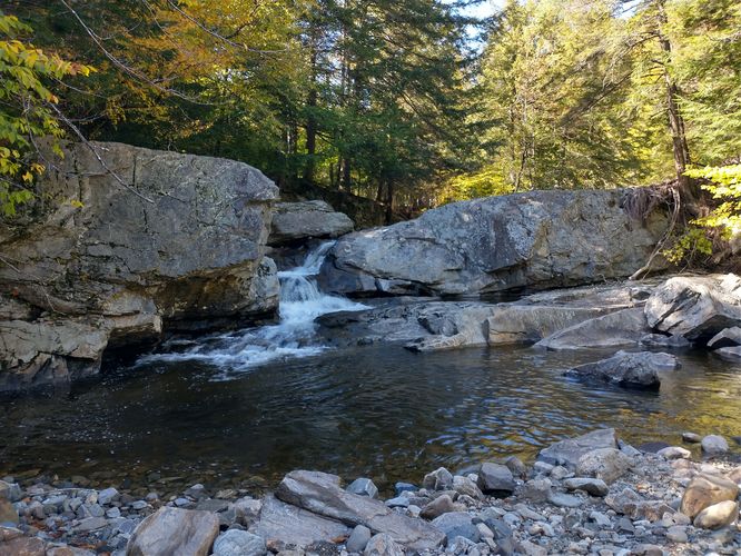
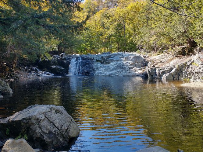
This area was greatly impacted by the Flood that occurred in July of 2023, and there is still a lot of tree debris remaining in the riverbed beyond the edges of the waterfall pools. In an effort to help this area recover from the Flood damage, a roped pathway has been installed. Hikers are asked to stay between the roped off path in order to protect the area from erosion, allow the vegetation to regenerate and to protect the quality of the water. There are no trail blazes, but the ropes act as trail markers. There are three sets of waterfalls here and each is unique and beautiful. The Middle Falls are the easiest to access and most visitors stop off at these Falls first due to its proximity to the trailhead. We decided to have our picnic here before exploring the other two Falls. At the Middle Falls visitors will enjoy the beautiful 20 foot high waterfall and the wide pool at its base. It's a great place to take a swim, or have a picnic like we did. It is too dangerous to dive here due to the debris that washed over the falls during the flood in 2023. Swimming is done at your own risk. Walking down to the lower falls is a bit more difficult. Visitors will need to be careful of roots and rocks that pose trip hazards along the trail. There are plenty of areas to walk out into the riverbed of Branch Brook, but use caution as the rocks are unstable and turning your ankle is easily done on this type of substrate. The falls here are not as high as the Middle Falls but are dramatic and fun to see. After visiting the Lower Falls we hiked back to the Middle Falls and continued up the trail to see the Upper Falls. The trail substrate here is a challenge; there are steep rocky sections that can be slippery due to the mist and spray emanating from the Falls. The Upper Falls and its large pool at the base are really beautiful and worth the little bit of time and effort to get there. It's hard to imagine that you are so close to a highway, yet able to feel so far away at this tranquil spot. After enjoying the Upper Falls we hiked the trail up the embankment to exit onto Buttermilk Falls Road. On this road there is an old bridge that has been blocked off from vehicles. The map at the kiosk showed this as gated, but it was in fact a huge mound of dirt with a footpath going through it. We took the footpath over the bridge to see Branch Brook from above. The path continues past the Falls area and eventually exits on to Routes 103. We hiked a short way down the footpath and turned around at the second โ€œgateโ€ which was another huge mound of dirt. We then headed back down Buttermilk Falls Road to our car. It was a lovely short hike with beautiful waterfalls.

Explore 10 trails near Ludlow, VT
  1. Parking

    43.435324, -72.726799
  2. Main Trailhead

    43.435446, -72.726749
  3. View of Lower Falls from riverbed

    43.435587, -72.726045
    View of Lower Falls from riverbed
  4. Downstream view of Upper Buttermilk Falls

    43.436318, -72.729571
    Downstream view of Upper Buttermilk Falls
No community routes found. To add your own hike as a Community Route for this Trail guide, leave a Trip Report with an attached GPX file.

Hazards

Ticks - Lyme Disease More Info (CDC)
Rockfalls / Ledges / or Scrambles

Seasons

All

Weather Forecast

In Ludlow, VT

Explore Hiking Trails

You May Also Like

Colorado's Million Dollar Highway - Plan a day's drive adventure along the iconic Million Dollar Highway in Colorado. Explore the best short trails, roadside stops, waterfalls, vistas, ghost towns, and hot springs within a ~6 hour road trip.
Explore

Colorado's Million Dollar Highway

Plan a day's drive adventure along the iconic Million Dollar Highway in Colorado. Explore the best short trails, roadside stops, waterfalls, vistas, ghost towns, and hot springs within a ~6 hour road trip.

Read
Glacier's Going-to-the-Sun Road - Discover the breathtaking beauty of Glacier National Park along the iconic Going-to-the-Sun Road. From stunning roadside stops to picturesque waterfalls and vistas, this engineering marvel offers endless opportunities for exploration.
Explore

Glacier's Going-to-the-Sun Road

Discover the breathtaking beauty of Glacier National Park along the iconic Going-to-the-Sun Road. From stunning roadside stops to picturesque waterfalls and vistas, this engineering marvel offers endless opportunities for exploration.

Read
New York's Best Waterfalls - Whether you're planning a day hike, roadside stop, or a leisurely short walk, this guide provides hikers, travelers, and locals alike with 63 different locations to over 100 scenic waterfalls to help plan your next adventure!
Explore

New York's Best Waterfalls

Whether you're planning a day hike, roadside stop, or a leisurely short walk, this guide provides hikers, travelers, and locals alike with 63 different locations to over 100 scenic waterfalls to help plan your next adventure!

Read

Before you boogie...

Find our trail guides useful? Consider becoming a Supporter to unlock perks!

MyHikes is an indie platform that makes exploring public trails easier for everyone. The platform has no investors, no ads, and is owned and operated by one person, Dave Miller. Dave has personally mapped and written over 1,800 trail guides on MyHikes for the public to explore. MyHikes has helped millions outdoor enthusiasts plan their next adventure.

But it takes a lot of time ๐Ÿ•ฆ, money ๐Ÿ’ฐ, work, and espresso shots โ˜• to run MyHikes, including hiking , mapping , writing , and publishing new trails with high-quality (accurate) information... along with software engineering (coding) the platform like building new features, website and mobile app development (iOS and Android), site maintainance . and much much more.

Supporters unlock website and mobile app perks with an annual one-time payment of $25 (you renew) ๐Ÿ˜Ž๐Ÿ‘. Or you can simply make a Donation of your choice. Otherwise, you can support us by telling your friends about MyHikes - both quick and free ๐ŸŽ‰

Admin user profile picture

Dave Miller
MyHikes Founder