Buttermilk Falls at Adirondack Park near Long Lake, New York in the Sargent Ponds Wild Forest is an easy 0.3-mile out-and-back hike that features the scenic 15-foot tall 150-foot long waterfall, Buttermilk Falls.
Hike Description
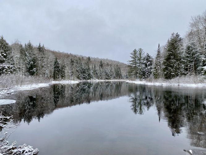
This very short hike begins along N Point Road near Long Lake, New York and follows the short dirt trail as it heads toward the Raquette River. This GPS track brings hikers first to the upper Buttermilk Falls portage where canoers and kayakers would hop out of the Raquette River to portage around the waterfall. Here, you'll get nice views of the Raquette River in addition to the upper reaches of Buttermilk Falls' cascading rapids.
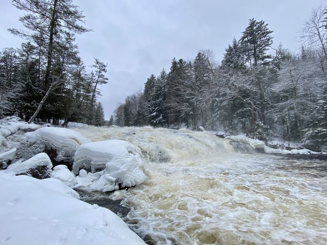
The trail then heads northward to reach the very-top of Buttermilk Falls cascade. From the top of Buttermilk Falls, hikers will get scenic views of the Raquette River facing downstream. From here, you can hike downhill alongside the waterfall to explore its side profile. In January 2024, as we trekked down alongside the waterfall, the river's high waters created a breathtaking display of the waterfall's natural power.
Base of Buttermilk Falls - Mile 0.14
Around mile 0.14 hikers will reach the base of the ~15-foot tall ~150-foot long Buttermilk Falls. The waterfall is several dozen feet wide as well, which can be best-viewed from the base of the cascade. Hikers will find boulders and spots they can stand to get a good view of the waterfall. During the winter, if it's been cold enough, you can walk out along the deep snowpack that sits above the Raquette River -- be careful though, as some of this icy snow can break through. From the base of Buttermilk Falls, hikers will get to enjoy the full natural beauty and power of this large but short waterfall.
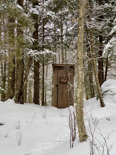
The hike back is simple, you can follow the same path you walked-in on to reach parking. You can also make your own route by walking through this picnic area. Note that there's at least one privy located off-trail.
Parking
Hikers will find parking at the coordinates provided along N Point Road in Long Lake, New York. The parking turnout is large enough to fit about 5 vehicles or less.
Pets
Dogs are allowed only if leashed and must be cleaned up after.
Hike Description
This very short hike begins along N Point Road near Long Lake, New York and follows the short dirt trail as it heads toward the Raquette River. This GPS track brings hikers first to the upper Buttermilk Falls portage where canoers and kayakers would hop out of the Raquette River to portage around the waterfall. Here, you'll get nice views of the Raquette River in addition to the upper reaches of Buttermilk Falls' cascading rapids.
The trail then heads northward to reach the very-top of Buttermilk Falls cascade. From the top of Buttermilk Falls, hikers will get scenic views of the Raquette River facing downstream. From here, you can hike downhill alongside the waterfall to explore its side profile. In January 2024, as we trekked down alongside the waterfall, the river's high waters created a breathtaking display of the waterfall's natural power.
Base of Buttermilk Falls - Mile 0.14
Around mile 0.14 hikers will reach the base of the ~15-foot tall ~150-foot long Buttermilk Falls. The waterfall is several dozen feet wide as well, which can be best-viewed from the base of the cascade. Hikers will find boulders and spots they can stand to get a good view of the waterfall. During the winter, if it's been cold enough, you can walk out along the deep snowpack that sits above the Raquette River -- be careful though, as some of this icy snow can break through. From the base of Buttermilk Falls, hikers will get to enjoy the full natural beauty and power of this large but short waterfall.
The hike back is simple, you can follow the same path you walked-in on to reach parking. You can also make your own route by walking through this picnic area. Note that there's at least one privy located off-trail.
Parking
Hikers will find parking at the coordinates provided along N Point Road in Long Lake, New York. The parking turnout is large enough to fit about 5 vehicles or less.
Pets
Dogs are allowed only if leashed and must be cleaned up after.