Loading...

📌 Love our trails? Set MyHikes as your preferred Google source. Add Now ⛰️

Burlington Falls

Looking for a scenic waterfall near Burlington, Connecticut with minimal effort but maximum payout? Look no further than the short walk to Burlington Falls!

Explore Burlington Falls

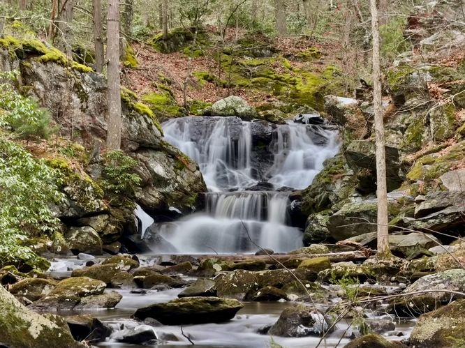
This short walk leads visitors along a discrete forest path and out to a downstream view of the ~15-foot tall Burlington Falls located in the middle of the forest of Burlington, Connecticut.

Most visitors would simply drive by this location without ever knowing a beautiful waterfall was located right off of the road. The easiest way to find this waterfall is to drive to the parking coordinates provided (41.785899, -72.962913) and look for the small forest path on the west side of Clear Brook Road -- located just south of the turn to Hotchkiss Road.

Follow the dirt path into the forest and follow it until it ends at the edge of Bunnell Brook. From here, you'll find a scenic downstream view of Burlington Falls with it sitting in the creek approximately 200-feet away. Please note that the brook is technically off-limits to the general public as it's a public water supply, however, you can appreciate Burlington Falls from this downstream forest path without trespassing!

When you're done enjoying the cascades flow, the walk back to parking takes just a minute or less.

Parking

Visitors will find roadside parking with no defined turnout or parking spaces near the coordinates provided: . The roadside parking spot can be found just south of Hotchkiss Road where it joins with Clear Brook Road in Burlington, CT.

Pets

Dogs are allowed only if leashed and must be cleaned up after.

Warning

Trespassing: Please avoid trespassing as the brook is a public water supply. The forest path that leads to the edge of the brook here appears to be publicly-accessible, but just up the road (closer to the waterfall), the town has posted "No Trespassing" signs as of December 2025.
Explore 29 trails near Burlington, CT

Know Before You Go

  • Enjoy the stunning downstream view from the public forest path, but do not enter the brook or get closer to the falls. The area directly around the waterfall is a public water supply and is strictly off-limits.
  • Because there are no signs or defined parking lots, look for an unmarked dirt path on the west side of Clear Brook Road, just south of the Hotchkiss Road turn.
  • You are welcome to bring your four-legged hiking buddies (dogs) along for the quick walk. Just make sure they stay on a leash and that you clean up after them.
Interactive topographic map for Burlington Falls located in Burlington, CT. Click the "View Map" button to load GPS coordinates and trail markers.
Get directions
Distance
N/A
Difficulty
Easy
Type
Out-and-Back
Est. Time
5 min
Elev. Gain
2'
Rating
0.0
Added
December 24, 2025
Updated
July 04, 2026

Weather Forecast

Don't let Google decide who you trust.

Loading...

Features

Dogs
Waterfalls
Water Source

Points of interest

  1. Parking

    41.785899, -72.962913
  2. Main Trailhead

    41.785899, -72.962913
  3. Burlington Falls, approx. 15-feet tall

    41.786069, -72.963242
    Burlington Falls, approx. 15-feet tall

Safety information

For your own safety: plan ahead, let someone know where you'll be, and hike at your own risk.

Hazards

Poison Ivy or Poison Oak

Availability

All seasons

Surface type

Dirt

Trip Reports (Reviews)

Your opinion matters! Be the first to rate this trail.

Ready to help fellow hikers? Add a trip report to share your experience!

No community routes found. To add your own hike as a Community Route for this Trail guide, leave a Trip Report with an attached GPX file.

You may also like

Colorado's Million Dollar Highway - Plan a day's drive adventure along the iconic Million Dollar Highway in Colorado. Explore the best short trails, roadside stops, waterfalls, vistas, ghost towns, and hot springs within a ~6 hour road trip.
Explore

Colorado's Million Dollar Highway

Plan a day's drive adventure along the iconic Million Dollar Highway in Colorado. Explore the best short trails, roadside stops, waterfalls, vistas, ghost towns, and hot springs within a ~6 hour road trip.

Read
Glacier's Going-to-the-Sun Road - Discover the breathtaking beauty of Glacier National Park along the iconic Going-to-the-Sun Road. From stunning roadside stops to picturesque waterfalls and vistas, this engineering marvel offers endless opportunities for exploration.
Explore

Glacier's Going-to-the-Sun Road

Discover the breathtaking beauty of Glacier National Park along the iconic Going-to-the-Sun Road. From stunning roadside stops to picturesque waterfalls and vistas, this engineering marvel offers endless opportunities for exploration.

Read
🍪 We use cookies to learn about site usage and to serve map tiles. You may block cookies manually in the browser. By continuing you agree. Learn more