Loading...

❄️ WINTER SALE! 50% OFF on Supporter Accounts — now through January 31st. Unlock a full year of exclusive website & app perks. Learn More.

Brushy Hills Loop Trail

Directions
Map
Pictures
Download Brushy Hills Loop Trail GPX Data to the MyHikes Mobile App
Distance:
5.4 Miles / 8.7 km
Type:
Loop
Difficulty:
Moderate
Time to Hike:
2 hours, ~42 minutes
Features:
Surface Type:
Dirt
Park:
Brushy Hills Preserve
Town:
Lexington, Virginia
Get Directions:
1010 Union Run Rd, Lexington, VA 24450

37.778155, -79.496449
Added:
June 12, 2025
Updated:
January 02, 2026
Guide by:
Copy Trail Link Hiking this trail? Send a friend or family member a link to this trail guide for your own safety. Hike at your own risk (disclaimer)
Loading...
Loading...
568'

Total Change
1,042'

Ascent
1,048'

Descent

Download the GPX Data for Offline Use

Supporters get exclusive access to download trail routes to the MyHikes app for offline use. Stay prepared on your adventure, even without an internet connection! Become a Supporter today to unlock this feature and hike with confidence.

Download Brushy Hills Loop Trail GPX Data to the MyHikes Mobile App

Know Before You Go

  • This loop traverses 12 different trails, including Ol' Red and Raven, leading hikers to the summit of Brushy Hill with smooth, rock-free terrain.
  • The Brushy Hills Preserve features well-maintained, uncrowded paths with signposts at every intersection, making it ideal for hikers and mountain bikers seeking solitude.
  • Leashed dogs are welcome on the trails, and hikers can choose from three convenient parking areas, including the main lot on Union Run Road.

Brushy Hills Loop Trail

This hike through Brushy Hills Preserve is a moderate 5.4-mile loop that leads to the summit of Brushy Hill and features an obstructed vista along the way.

About Brushy Hills Preserve

The Brushy Hills Preserve is a well maintained hiking area with a series of different trails. The Preserve is not well known and therefore is generally not crowded. The trails are open to mountain bikers but not horses. At the main parking area, there are paper maps provided but a digital copy can be found at https://www.friendsofbrushyhills.org/brushy-hills-info.html

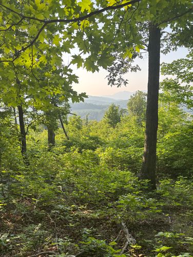
The trails are smooth with little to no rocks or other tripping hazards. There are no blazes but a sign post at every intersections making the area easy to navigate. Most trails in the preserve are about 1 mile or less so creating a route of any length is easy. The area is beautiful but there is no overlooks/views during the summer months when the leaves are on the trees. The main parking area is at the low point all trails lead up onto the ridge.

Trail Guide

This hike begins at the main parking lot located along Union Run Road and heads north along the eastern side of the park, following 'Ol Red Trail first. From 'Ol Red, the hike traverses the Pickle Trail as it continues north bound as it heads toward the summit of Brushy Hill. Along the way toward the summit, you'll turn onto the Tin Cup Trail before reaching the Twist and Raven Trails. The hike then passes an obstructed vista along the Twist near the junction of the Raven Trail. Finally, along the Raven Trail, hikers will pass the summit of Brushy Hill where the hike descends back toward parking along the northwest and west sides of the park.

Once you pass the Brushy Hill summit, the hike follows several trails as you traverse back to the parking lot. Starting with the Raven Trail, you'll pass through the forest following the Knoll Trail, Green Trail, Gateway Trail, Ridge Trail, Turtle Trail,  Salad Bowl Trail, and finally the Turtle Trail to reach the parking lot.  

Trails

This route follow several named trails in the following order:  Ol' Red > Pickle > Tin Cup > Twist > Raven > Knoll > Green > Gateway > Ridge > Turtle > Salad Bowl > Turtle.

Parking

There are 3 parking areas:
- Main Lot (direction coordinates / shown on map): 1010 Union Run Rd
- Upper Lot: 1371 Union Run Road
- Back Lot: 1311 Enfield Road

Pets

Dogs are allowed only if leashed and must be cleaned up after.
Explore 40 trails near Lexington, VA
  1. Parking

    37.778155, -79.496449
  2. Main Trailhead

    37.77819, -79.496364
  3. Obstructed vista

    37.788072, -79.487349
    Obstructed vista
No community routes found. To add your own hike as a Community Route for this Trail guide, leave a Trip Report with an attached GPX file.

Hazards

Ticks - Lyme Disease More Info (CDC)
Snakes
Poison Ivy/Oak

Seasons

All

Photo Albums

+ Add Photo Album

Upload your photos from the trail to help others know what to expect.

Trip Reports (Reviews)

Ready to help fellow hikers? Add a trip report to share your experience and provide valuable insights for those planning their next hike. Your review makes the trail better for everyone.

Your opinion matters! Be the first to rate this trail.

Weather Forecast

In Lexington, VA

Explore Hiking Trails

You May Also Like

25 Best Day Hikes in North Carolina - Discover the top 25 best day hikes in North Carolina, from breathtaking waterfalls to mountain peaks. Explore hidden gems, scenic views, and trails suitable for all skill levels, perfect for your next outdoor adventure.
Explore

25 Best Day Hikes in North Carolina

Discover the top 25 best day hikes in North Carolina, from breathtaking waterfalls to mountain peaks. Explore hidden gems, scenic views, and trails suitable for all skill levels, perfect for your next outdoor adventure.

Read

Before you boogie...

Find our trail guides useful? Consider becoming a Supporter to unlock perks!

MyHikes is an indie platform that makes exploring public trails easier for everyone. The platform has no investors, no ads, and is owned and operated by one person, Dave Miller. Dave has personally mapped and written over 1,900 trail guides on MyHikes for the public to explore. MyHikes has helped millions outdoor enthusiasts plan their next adventure.

But it takes a lot of time 🕦, money 💰, work, and espresso shots ☕ to run MyHikes, including hiking , mapping , writing , and publishing new trails with high-quality (accurate) information... along with software engineering (coding) the platform like building new features, website and mobile app development (iOS and Android), site maintainance . and much much more.

Supporters unlock website and mobile app perks with an annual one-time payment of $25 (you renew) 😎👍. Or you can simply make a Donation of your choice. Otherwise, you can support us by telling your friends about MyHikes - both quick and free 🎉

Admin avatar

Dave Miller
MyHikes Founder
🍪 We use cookies to learn about site usage, performance, and to serve map tiles. You may block cookies manually in the browser. By continuing to use MyHikes, you agree. Learn more