This is a lollipop (or lariat) hike, almost entirely within federally designated wilderness, that takes you to the largest watershed in Shenandoah National Park. It also reaches the most remote parts of the entire park – you will find yourself over four miles away from the closest public trailhead. For this reason, this is also a great route for an overnight backpack, as there are multiple fine campsites along Big Run (though no facilities – so be sure to know how to camp using Leave No Trace principles!)
Adding to the journey’s interest is the fact that this entire area burned in the Spring of 2016 in the second largest fire in Shenandoah National Park history. The Big Run Portal Trail served as the southern boundary for the fire, and the Brown Mountain Trail slices through the middle of the burn zone. The forest heals fairly quickly, however, and each trip through the area reveals changes as the forest recovers.
This hike alternately can be completed as a clockwise loop (heading downhill to Big Run from the first trail intersection) or counter-clockwise (remaining on the Brown Mountain Trail). If hiking this as a day hike, we recommend descending to Big Run at the beginning. If you first hike the entire Brown Mountain Trail, you will have an unrelenting climb of 1400 feet over the last three miles of this hike. Hiked in either direction, there is a stiff climb over the last 0.7 miles of the trek, as you return to the high point of the journey – the trailhead.
This is a challenging hike, so here are a few caveats. Be sure to bring plenty of water and/or a filter if hiking this route in the summer. Parts of this loop are exposed to the sun and can be very dry. Also bring a good map of the area as there are multiple trail intersections along the way. The best trail map for this area is the PATC Map 11 –Shenandoah National Park South District (available for sale within the Park), as it is regularly updated and checked for accuracy. And Big Run may be difficult or impossible to ford in times of high water. A good map can help you plan for alternative routes if you are challenged in any stream crossings.
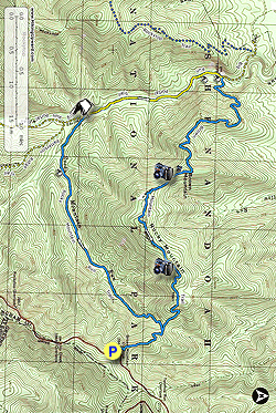
- Mile 0.0 – Parking for this hike is located at the Skyline Drive’s Brown Mountain Overlook, located just north of Milepost 77. A short rock wall forms the boundary of the overlook, which provides parking for about a dozen vehicles and a great view of the Big Run drainage. A break in the rock wall is where the blue blazed Brown Mountain Trail starts. Take this downhill from the overlook.
- Mile 0.7 – Reach a saddle where the Rocky Mountain Run Trail meets the blue blazed Brown Mountain Trail. You can choose either direction here, but turning left down the Rocky Mountain Run Trail is recommended and is described here.
- Mile 1.9 – Descend steadily for over a mile via a series of switchbacks past burned trees. Drop from over 2800 feet elevation at the start of the hike to just under 1400 feet elevation at this point. Cross Rocky Mountain Run twice in quick succession.
- Mile 2.6 – Cross Rocky Mountain Run a third time.
- Mile 2.8 – There is a nice campsite to the left of the trail here, alongside Rocky Mountain Run.
- Mile 3.5 – The Rocky Mountain Run Trail ends where it meets the yellow blazed Big Run Portal Trail. Go to the right here. The first of several nice campsites can be seen almost immediately on your left as you start down the Big Run Portal Trail, on your left, next to Big Run. The Big Run Portal Trail is an old fire road, no longer used as a road now that this is federally designated wilderness. Horses are allowed on the Big Run Portal Trail, but not on the other two trails that compose this hike.
- Mile 3.7 – Cross Big Run, the first of several crossings of this stream. Crossing may be difficult or impossible during times of high water.
- Mile 3.8 – Cross Big Run again.
- Mile 4.3 – Cross Big Run. During summer, there are nice flowers growing along the stream bank here.
- Mile 4.8 – Just after the fourth crossing of Big Run, a trail to the right leads 20 feet to a nice campsite, situated up above the trail and stream. Along this portion of the trail, note that the fire ended at the trail, with trees to your right showing evidence of fire, and trees on your left absent fire scars.
- Mile 5.1 – To the left of the trail, along Big Run, is the last campsite of the hike, located under some conifers with access to the stream, just upstream from the metal bridge described in the next section.
- Mile 5.3 – The intersection with the blue blazed Brown Mountain Trail is here, but continue on the Big Run Portal Trail for a few more feet to come to a metal bridge spanning Big Run. Here you can get the full effect of the “Portal,” which are high rocks on either side of the stream. This bridge is a wonderful spot to soak in the solitude, listen to the birds, and look at the trees. Take your time here! Continuing on the Big Run Portal Trail past the bridge would take you out of federally designated wilderness. The trail continues a little further to the Rockytop Trail, which heads back to the Skyline Drive several miles south of your trailhead. There is no public access to this valley from outside of the national park. It is as remote as you can get in Shenandoah National Park. Make sure you have enough water for the rest of your hike. Once you leave Big Run there are no more water sources on this hike. This hike’s entire climb lies in front of you, as you are at the low point of the hike right now, and the high point is back where you left your vehicle.
- Mile 6.5 – Backtrack a few yards to the intersection with the Brown Mountain Trail and take a left at the concrete mileage post. Take a right at the second post, only a few feet further, and start climbing Brown Mountain. As you climb, you will notice that there is not much tree cover in this part of the hike. This is the result of a 1986 fire that was started, like the 2016 fire, by a camper’s careless use of fire. Another reminder to please be careful if making this an overnight!
- Mile 7.4 – After ascending multiple switchbacks over rocky trail where you can catch views of the Big Portal area as you climb, and further west see the southern tip of the Massanutten range, you will crest the top of Brown Mountain and come to a rocky area with some obstructed views of nearby mountains. Only about 500 feet further, if you care to climb the steep slope on your right side of the trail after the trail cuts to the left of the ridge, you crest at a spot with spectacular views. But it isn’t marked, and there is no trail.
- Mile 8.7 – The trail dips and rises several times before summiting Rocky Mountain, with occasional nice views along the way. Shortly afterward is the best overlook on the trail, looking west towards the Skyline Drive and your vehicle – waiting for you at the trailhead. If you still have a snack or water, you will want to stop here and enjoy the view.
- Mile 9.6 – The trail drops off of the crest of Rocky Mountain and descends to complete your loop at the intersection with the Rocky Mountain Run Trail at a saddle in the ridge. The last 0.7 miles involves a backtrack uphill to the Skyline Drive and your vehicle.
- Mile 10.3 – Return to the parking area and look back to check out the entire valley you traveled through.