Loading...

Distance:
0.6 Miles / 1.0 km
Type:
Out-and-Back
Difficulty:
Moderate
Time to Hike:
~18 minutes
Features:
Surface Type:
Dirt
Park:
Bridal Veil Falls State Scenic Viewpoint
Town:
Corbett, Oregon
Directions:
45.553023, -122.183564
Added:
December 10, 2017
Updated:
March 06, 2018
Loading...
Loading...
132 '

Total Change
167 '

Ascent
170 '

Descent

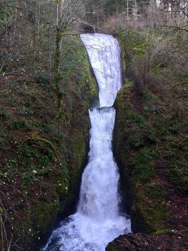
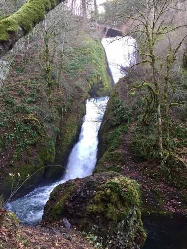
The Bridal Veil Falls Trail in Corbett, Oregon is a moderate 0.6 mile out-and-back hike to the base of Bridal Veil Falls in the heart of the Columbia River Gorge. Bridal Veil Falls has two main cascades and according to the state park's website, the two cascades in total are about 120 feet tall.

The trail that leads down to the falls is not wheelchair accessible and has a couple of switchbacks before reaching Bridal Veil Creek. Cross the bridge at the creek and follow the trail back uphill for about 60 feet to a lookout point directly in front of the falls.

The entire hike is about 0.6 miles out-and-back and is moderate based on the short distance and elevation gain heading back to parking, which is about 70 feet. This is one of the best waterfalls outside of Portland, Oregon within a short 30 minute drive of the city.

For additional views of the Columbia River, check out the short Bridal Veil Overlook Loop Trail before heading out.

Explore 17 trails near Corbett, OR
  1. Parking

    45.553023, -122.183564
  2. Main Trailhead

    45.553454, -122.182765
  3. Bridal Veil Falls, Oregon

    45.555019, -122.180014
    Bridal Veil Falls, Oregon
  4. Bridal Veil Falls, Oregon

    45.555017, -122.180016
    Bridal Veil Falls, Oregon
No community routes found. To add your own hike as a Community Route for this Trail guide, leave a Trip Report with an attached GPX file.

Seasons

All

Photo Albums

2 Trip Reports

No Star-Ratings
Trail Guide By:
Admin user profile picture
0.6 miles / 1.0 km
Trail added
December 10, 2017
Hiked on
December 08, 2017
Updated on
March 06, 2018
0.6 miles / 1.0 km
April 02, 2023
Trail conditions - extremely slippery muddy after 3 days of constant rain. Sights - Euphoric glassy falls, accessible to public. Large ledges with multiple layers of beautiful rock.
Hiking

Weather Forecast

In Corbett, OR

Explore Hiking Trails

New Hikes

Beaver Ponds Trail
0.1 Miles
0.2 km
Easy
Out-and-Back
Hidden Valley Creek Trail
0.3 Miles
0.5 km
Easy
Out-and-Back
Estes Park Riverwalk
0.9 Miles
1.4 km
Easy
Out-and-Back
Shortoff Trail
5.5 Miles
8.9 km
Hard
Out-and-Back

Before you boogie...

Find our trail guides useful? Consider becoming a Supporter to unlock perks!

MyHikes is an indie platform that makes exploring public trails easier for everyone. The platform has no investors, runs no ads, and is owned and operated by one person, Dave Miller. Dave has personally mapped and written over 1,600 trail guides on MyHikes for the public to explore. As of 2024, MyHikes has helped over 1,300,000 outdoor enthusiasts plan their next adventure.

But it takes a lot of time 🕦, money 💰, and work, and espresso shots ☕ to run MyHikes, including hiking , mapping , writing , and publishing new trails with high-quality (accurate) information... along with software engineering (coding) the platform like building new features, site and mobile app development for iOS and Android, site maintainance . and much much more.

Supporters unlock website and mobile app perks with an annual one-time payment of $25 (you renew) 😎👍. Or you can simply make a Donation of your choice. Otherwise, you can support us by telling your friends about MyHikes - both quick and free 🎉

Admin user profile picture

Dave Miller
MyHikes Founder