Loading...

๐ŸŽ† 50% off 4th of July sale on Supporter Accounts โ€” now through July 6! Learn More.

Boy Scout Tree Trail

Directions
Map
Pictures
Send to App
Distance:
5.6 Miles / 9.0 km
Type:
Out-and-Back
Difficulty:
Moderate
Time to Hike:
2 hours, ~48 minutes
Features:
Surface Type:
Dirt
Park:
Jedediah Smith Redwoods State Park
Town:
Crescent City, California
Directions:
41.768532, -124.110255
Added:
August 09, 2019
Updated:
March 18, 2025
Copy Trail Link Hiking this trail? Send a friend or family member a link to this trail guide for your own safety. Hike at your own risk (disclaimer)
Loading...
Loading...
508'

Total Change
1,635'

Ascent
1,642'

Descent

Download the Trail Route for Offline Use

Supporters get exclusive access to download trail routes to the MyHikes app for offline use. Stay prepared on your adventure, even without an internet connection! Become a Supporter today to unlock this feature and hike with confidence.

Send to App

Boy Scout Tree Trail

The Boy Scout Tree Trail at Jedediah Smith Redwoods State Park in Crescent City, California is a moderate 2.8-mile out-and-back trail that leads to a waterfall, Fern Falls.

The trailhead is on the left side of Howland Hill Road. This trail is a beautiful forested path that will take you through some huge redwoods along the way to Fern Falls. A bit more than half-way to Fern Falls, the trail heads up a set of stairs to the Boy Scout Redwood tree.
After the Boy Scout tree, you will head back down to the main trail and continue onward a short distance to Fern Falls.

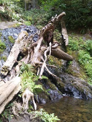
The falls have a nice resting spot where visitors can enjoy the view. If you visit during mid-Summer, Fern Falls may be somewhat dried up, so plan your hike around heavy rains or the Spring to see Fern Falls in action.

Parking: Parking can be found at the coordinates provided, by the trailhead.

Water sources: If you carry a water filter, you can refill your water bottle from the streams along the trail.

Pets: Dogs are not allowed on this trail or at Jedediah Smith Redwoods State Park.

Biking: Biking is not allowed on this trail.

Camping: Camping and backpacking is not allowed on this trail.
Explore 27 trails near Crescent City, CA
  1. Parking

    41.768532, -124.110255
  2. Main Trailhead

    41.768632, -124.109929
  3. Fern Falls

    41.784057, -124.139996
    Fern Falls
No community routes found. To add your own hike as a Community Route for this Trail guide, leave a Trip Report with an attached GPX file.

Hazards

Ticks - Lyme Disease More Info (CDC)
Snakes
Poison Ivy/Oak

Seasons

All

Trip Reports

Trail Guide By:
VanDemanJr user profile picture
5.6 miles / 9.0 km

Weather Forecast

In Crescent City, CA

Explore Hiking Trails

You May Also Like

Colorado's Million Dollar Highway - Plan a day's drive adventure along the iconic Million Dollar Highway in Colorado. Explore the best short trails, roadside stops, waterfalls, vistas, ghost towns, and hot springs within a ~6 hour road trip.
Explore

Colorado's Million Dollar Highway

Plan a day's drive adventure along the iconic Million Dollar Highway in Colorado. Explore the best short trails, roadside stops, waterfalls, vistas, ghost towns, and hot springs within a ~6 hour road trip.

Read
Glacier's Going-to-the-Sun Road - Discover the breathtaking beauty of Glacier National Park along the iconic Going-to-the-Sun Road. From stunning roadside stops to picturesque waterfalls and vistas, this engineering marvel offers endless opportunities for exploration.
Explore

Glacier's Going-to-the-Sun Road

Discover the breathtaking beauty of Glacier National Park along the iconic Going-to-the-Sun Road. From stunning roadside stops to picturesque waterfalls and vistas, this engineering marvel offers endless opportunities for exploration.

Read
New York's Best Waterfalls - Whether you're planning a day hike, roadside stop, or a leisurely short walk, this guide provides hikers, travelers, and locals alike with 63 different locations to over 100 scenic waterfalls to help plan your next adventure!
Explore

New York's Best Waterfalls

Whether you're planning a day hike, roadside stop, or a leisurely short walk, this guide provides hikers, travelers, and locals alike with 63 different locations to over 100 scenic waterfalls to help plan your next adventure!

Read

Before you boogie...

Find our trail guides useful? Consider becoming a Supporter to unlock perks!

MyHikes is an indie platform that makes exploring public trails easier for everyone. The platform has no investors, no ads, and is owned and operated by one person, Dave Miller. Dave has personally mapped and written over 1,800 trail guides on MyHikes for the public to explore. MyHikes has helped millions outdoor enthusiasts plan their next adventure.

But it takes a lot of time ๐Ÿ•ฆ, money ๐Ÿ’ฐ, work, and espresso shots โ˜• to run MyHikes, including hiking , mapping , writing , and publishing new trails with high-quality (accurate) information... along with software engineering (coding) the platform like building new features, website and mobile app development (iOS and Android), site maintainance . and much much more.

Supporters unlock website and mobile app perks with an annual one-time payment of $25 (you renew) ๐Ÿ˜Ž๐Ÿ‘. Or you can simply make a Donation of your choice. Otherwise, you can support us by telling your friends about MyHikes - both quick and free ๐ŸŽ‰

Admin user profile picture

Dave Miller
MyHikes Founder