Loading...

๐ŸŽ† 50% off 4th of July sale on Supporter Accounts โ€” now through July 6! Learn More.

Borer's Falls Trail

Directions
Map
Pictures
Send to App
Distance:
0.2 km / 0.1 Miles
Type:
Out-and-Back
Difficulty:
Easy
Time to Hike:
~5 minutes
Features:
Surface Type:
Dirt
Town:
Hamilton, Ontario - Canada
Directions:
43.290575, -79.937242
Added:
August 11, 2024
Updated:
August 27, 2024
Copy Trail Link Hiking this trail? Send a friend or family member a link to this trail guide for your own safety. Hike at your own risk (disclaimer)
Loading...
Loading...
5m

Total Change
5m

Ascent
5m

Descent

Download the Trail Route for Offline Use

Supporters get exclusive access to download trail routes to the MyHikes app for offline use. Stay prepared on your adventure, even without an internet connection! Become a Supporter today to unlock this feature and hike with confidence.

Send to App

Borer's Falls Trail

Borer's Falls Trail in Hamilton, Ontario is an easy 0.1 km out-and-back walk that leads to a viewpoint of the 15 m (49.2-foot) tall waterfall, Borer's Falls.

Hike to Borer's Falls
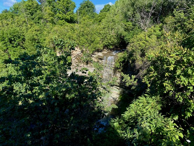
The trailhead for Borer's Falls is located on the south side of Rock Chapel Road located on the curve near Rock Chapel Creek. The trailhead has very-little signage as of August 2024 aside from a Hamilton Conservation Authority and a dog-on-leash sign. The trail leads into the forest alongside a wide-open field, which appears to be private land -- so please stay on-trail. Located just 0.05 km from the trailhead, visitors will find the free-falling waterfall, Borer's Falls, cascading over a cliff of Niagara Escarpment. The view of Borer's Falls is a bit overgrown, especially during the Summer when the trees and overgrowth's vegetation covers the view.

Warnings
Steep cliffs: The viewpoint for Borer's Falls sits adjacent to a very steep cliff with sheer drop-offs. It's difficult to tell, especially during the warm months when vegetation covers the landscape, but you should always stay back from the cliff for your own safety.

Road walk: To reach this trailhead you must either be dropped-off or park at the public parking area and walk down Rock Chapel Road. Note that there's no legal parking at the trailhead.
Explore 14 trails near Hamilton, ON
  1. Parking

    43.290575, -79.937242
  2. Main Trailhead

    43.294033, -79.936777
  3. Borer's Falls

    43.293731, -79.936447
    Borer's Falls
No community routes found. To add your own hike as a Community Route for this Trail guide, leave a Trip Report with an attached GPX file.

Hazards

Poison Ivy/Oak
Rockfalls / Ledges / or Scrambles

Seasons

All

Photo Albums

Trip Reports

Trail Guide By:
Admin user profile picture
0.1 miles / 0.2 km
0.1 miles / 0.2 km
August 11, 2024
Hiking

Weather Forecast

In Hamilton, ON

Explore Hiking Trails

You May Also Like

Colorado's Million Dollar Highway - Plan a day's drive adventure along the iconic Million Dollar Highway in Colorado. Explore the best short trails, roadside stops, waterfalls, vistas, ghost towns, and hot springs within a ~6 hour road trip.
Explore

Colorado's Million Dollar Highway

Plan a day's drive adventure along the iconic Million Dollar Highway in Colorado. Explore the best short trails, roadside stops, waterfalls, vistas, ghost towns, and hot springs within a ~6 hour road trip.

Read
Glacier's Going-to-the-Sun Road - Discover the breathtaking beauty of Glacier National Park along the iconic Going-to-the-Sun Road. From stunning roadside stops to picturesque waterfalls and vistas, this engineering marvel offers endless opportunities for exploration.
Explore

Glacier's Going-to-the-Sun Road

Discover the breathtaking beauty of Glacier National Park along the iconic Going-to-the-Sun Road. From stunning roadside stops to picturesque waterfalls and vistas, this engineering marvel offers endless opportunities for exploration.

Read
New York's Best Waterfalls - Whether you're planning a day hike, roadside stop, or a leisurely short walk, this guide provides hikers, travelers, and locals alike with 63 different locations to over 100 scenic waterfalls to help plan your next adventure!
Explore

New York's Best Waterfalls

Whether you're planning a day hike, roadside stop, or a leisurely short walk, this guide provides hikers, travelers, and locals alike with 63 different locations to over 100 scenic waterfalls to help plan your next adventure!

Read

Before you boogie...

Find our trail guides useful? Consider becoming a Supporter to unlock perks!

MyHikes is an indie platform that makes exploring public trails easier for everyone. The platform has no investors, no ads, and is owned and operated by one person, Dave Miller. Dave has personally mapped and written over 1,800 trail guides on MyHikes for the public to explore. MyHikes has helped millions outdoor enthusiasts plan their next adventure.

But it takes a lot of time ๐Ÿ•ฆ, money ๐Ÿ’ฐ, work, and espresso shots โ˜• to run MyHikes, including hiking , mapping , writing , and publishing new trails with high-quality (accurate) information... along with software engineering (coding) the platform like building new features, website and mobile app development (iOS and Android), site maintainance . and much much more.

Supporters unlock website and mobile app perks with an annual one-time payment of $25 (you renew) ๐Ÿ˜Ž๐Ÿ‘. Or you can simply make a Donation of your choice. Otherwise, you can support us by telling your friends about MyHikes - both quick and free ๐ŸŽ‰

Admin user profile picture

Dave Miller
MyHikes Founder