The Boone Run Crags at Tioga State Forest in Blossburg, Pennsylvania is difficult 0.3-mile out-and-back off-trail scramble that leads up to 20-foot rock cliffs and massive boulders on the mountainside.
Trails
This hike follows the official, unblazed, and multipurpose Boone Run Trail for just a few dozen feet before the hiker veers off-trail for a bushwhack and rock scramble.
Hike Description
This hike begins on the off-ramp of PA-15 for the Blossburg exit (southbound) and heads into the woods. As of December 2022, there's a metal fence that's been pushed down at the trailhead; however, all of the land from the off-ramp to the trailhead is technically public land. Cross the fence line and you're already in Tioga State Forest. Follow the unmaintained Boone Run Trail uphill for less than 20-feet before turning to the right-hand side to head off-trail and up to the rocky outcropping.
Hillside Rock Scramble - Trailhead to Mile 0.1
After leaving the trail, hikers will be faced with an off-trail rock scramble that leads up a fairly-steep mountainside. The biggest obstacle along the way up, aside from the elevation gain, are the loose rocks covered in a thick layer of leaves with holes between, around, and under them. There's a very large rock field that requires slow traversing to ensure that you don't twist an ankle or accidentally fall over due to the rocky uneven terrain.
Crags, Boulders, Cliffs, and Caves - Mile 0.1 to 0.15
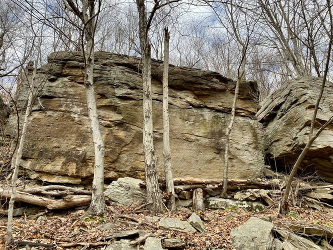
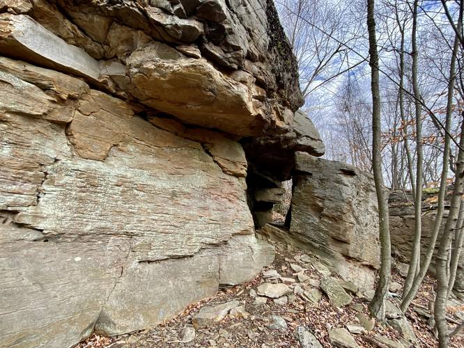
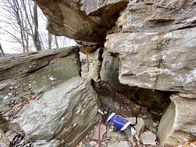
Once near the top of the mountain, just 0.1-miles from the parking area, hikers will reach the main section of the Boone Run Crags. It's obviously noted by the large 20-foot cliffs and massive boulders that have large cutouts between them. Hikers can walk between and around these massive boulders and bedrock formations for some fun adventuring. A keen eye might notice a pattern of circular carvings in the rocks at a uniform level (seemingly from the waist down) along some of these boulders - these carvings appear to be made by water, indicating that maybe these rocks were cut, carved, and sliced by glacial activity thousands of years ago; however, since I'm not a geologist, this is just speculation based on my observations. Also note that some of these rocky overhangs provide "cave-like" features or rock enclosures, albeit they're mostly-sunlit and maneuverable by people - watch your head as rocks could fall at any time! Once you're at the top of the mountain, you can venture as far west or northeast as you wish since the rocks continue for quite a while. Upon this hike, reaching this particular section was good enough for me and Jax, so we took off after reaching the cave-like enclosure. Last, upon this trip in early December 2022, Jax and I found a porcupine den marked by its massive pile of scat outside a small cave entrance. Watch out as you may run into porcupines out here!
Hiking Down
While it sounds silly to note, hiking out of here was harder than hiking in. Due to the leaf-covered rocks, uneven terrain, steep slopes of boulders, and uneven footing, getting down the hill from the Boone Run Crags was harder than hiking up to them. Take your time and plan on spending about 30 minutes here since the going is so slow.
Climbing / Bouldering
The Boone Run Crags or Boone Run Boulders is a potential climbing spot as a lot of the rock is not a loose shale or slate. This is a great bouldering spot as well and not too far from the road.
Parking
Please note that the parking coordinates for this hike lead you to a highway off-ramp for PA-15 at the South-bound exit for Blossburg. Hikers can actually park their vehicles at the end of Boone Run Rd to hike into the woods from there (near the coordinates: 41.674205, -77.078478). You can also park at the end of Boone Run Rd and hike up along the grass off of the highway off-ramp to this trailhead as well.
Pets
Dogs are allowed if leashed and their waste should be carried out by the hiker.
Camping & Backpacking
While there are no campsites along this hike, Tioga State Forest does allow primitive / dispersed / backcountry camping. Please follow all state forest rules and regulations when camping on state land.
Warnings
Porcupine & Rattlesnake dens: These rocks are home to porcupines and possibly the Timber Rattlesnake. It's best to visit these rocks when it's cold out and to ensure the chances of running into snakes is low.
Rocky terrain: The hike up to the rocky outcropping is very rocky and hikers can easily twist an ankle.
Trails
This hike follows the official, unblazed, and multipurpose Boone Run Trail for just a few dozen feet before the hiker veers off-trail for a bushwhack and rock scramble.
Hike Description
This hike begins on the off-ramp of PA-15 for the Blossburg exit (southbound) and heads into the woods. As of December 2022, there's a metal fence that's been pushed down at the trailhead; however, all of the land from the off-ramp to the trailhead is technically public land. Cross the fence line and you're already in Tioga State Forest. Follow the unmaintained Boone Run Trail uphill for less than 20-feet before turning to the right-hand side to head off-trail and up to the rocky outcropping.
Hillside Rock Scramble - Trailhead to Mile 0.1
After leaving the trail, hikers will be faced with an off-trail rock scramble that leads up a fairly-steep mountainside. The biggest obstacle along the way up, aside from the elevation gain, are the loose rocks covered in a thick layer of leaves with holes between, around, and under them. There's a very large rock field that requires slow traversing to ensure that you don't twist an ankle or accidentally fall over due to the rocky uneven terrain.
Crags, Boulders, Cliffs, and Caves - Mile 0.1 to 0.15
Once near the top of the mountain, just 0.1-miles from the parking area, hikers will reach the main section of the Boone Run Crags. It's obviously noted by the large 20-foot cliffs and massive boulders that have large cutouts between them. Hikers can walk between and around these massive boulders and bedrock formations for some fun adventuring. A keen eye might notice a pattern of circular carvings in the rocks at a uniform level (seemingly from the waist down) along some of these boulders - these carvings appear to be made by water, indicating that maybe these rocks were cut, carved, and sliced by glacial activity thousands of years ago; however, since I'm not a geologist, this is just speculation based on my observations. Also note that some of these rocky overhangs provide "cave-like" features or rock enclosures, albeit they're mostly-sunlit and maneuverable by people - watch your head as rocks could fall at any time! Once you're at the top of the mountain, you can venture as far west or northeast as you wish since the rocks continue for quite a while. Upon this hike, reaching this particular section was good enough for me and Jax, so we took off after reaching the cave-like enclosure. Last, upon this trip in early December 2022, Jax and I found a porcupine den marked by its massive pile of scat outside a small cave entrance. Watch out as you may run into porcupines out here!
Hiking Down
While it sounds silly to note, hiking out of here was harder than hiking in. Due to the leaf-covered rocks, uneven terrain, steep slopes of boulders, and uneven footing, getting down the hill from the Boone Run Crags was harder than hiking up to them. Take your time and plan on spending about 30 minutes here since the going is so slow.
Climbing / Bouldering
The Boone Run Crags or Boone Run Boulders is a potential climbing spot as a lot of the rock is not a loose shale or slate. This is a great bouldering spot as well and not too far from the road.
Parking
Please note that the parking coordinates for this hike lead you to a highway off-ramp for PA-15 at the South-bound exit for Blossburg. Hikers can actually park their vehicles at the end of Boone Run Rd to hike into the woods from there (near the coordinates: 41.674205, -77.078478). You can also park at the end of Boone Run Rd and hike up along the grass off of the highway off-ramp to this trailhead as well.
Pets
Dogs are allowed if leashed and their waste should be carried out by the hiker.
Camping & Backpacking
While there are no campsites along this hike, Tioga State Forest does allow primitive / dispersed / backcountry camping. Please follow all state forest rules and regulations when camping on state land.
Warnings
Porcupine & Rattlesnake dens: These rocks are home to porcupines and possibly the Timber Rattlesnake. It's best to visit these rocks when it's cold out and to ensure the chances of running into snakes is low.
Rocky terrain: The hike up to the rocky outcropping is very rocky and hikers can easily twist an ankle.