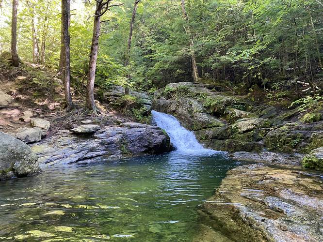
The Blueberry Mountain Hike at the White Mountain National Forest near Stow, Maine is a moderate 5.7-mile out-and-back trail that features a stunning overlook from the summit, a brook flume with a waterfall, and a emerald green wading pool alongside a 15-foot waterfall, named Rattlesnake Pool.
Trails
This hike follows several named trails: Stone House Trail, Blueberry Ridge Trail, Lookout Loop Trail (at the summit of Blueberry Mountain).
Hike Description
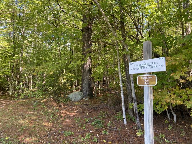
This trek begins at a dead end of a road located on Shell Pond Road in near Stow, Maine. The road has a large green metal gate, which is technically private property for the Stone House. Hikers must follow the rules and stay on the USFS/CTA blazed trails or the driveway at all times. The trail heads east, following the road / driveway for about 0.55-miles before hikers will reach the Stone House Trail on the left-hand side. The Stone House Trail heads up Blueberry Mountain at a very gradual grade for the first half of the trail.
The Flume
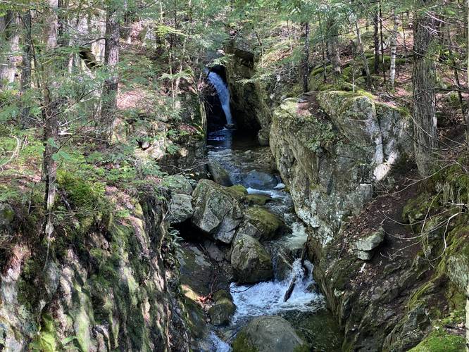
Hikers will reach a sign labeled "Gorge" around mile 0.8 - hike to the east to view the brook flume and waterfall upstream. The trails that continue on from the bridge are located on private property, so the hike heads back to the main trail after the flume.
Rattlesnake Pool with 15-foot Waterfall
Around mile 1.1 (if including the walk to and from the flume), hikers will reach another sign on the trail - this one is labeled for Rattlesnake Pool. Down this short spur trail is a beautiful emerald green swimming hole located at the base of a 15-foot waterfall. There's a steep hillside, about 15-feet tall, that hikers will have to scramble down to get a good view of the waterfall. During the heat of the Summer, this is a popular swimming spot.
Hiking to the Summit
After visiting Rattlesnake Pool and the waterfall, there's nothing left to see along this trail until the hiker reaches the top of Blueberry Mountain, around mile 2.84. The hike up is moderate, in my opinion, as the trail follows many switchbacks when it reaches the steeper grade of the mountain. The only noteworthy section of the climb up is the ~50-foot section of granite rock that the hiker must scramble up on a moderate grade. At the top, the hiker will find a steep rocky section atop the mountain - look for rock cairns, as this is the way to find the Lookout Loop Trail. Blueberry Mountain's summit is located off-trail from the Lookout Loop Trail.
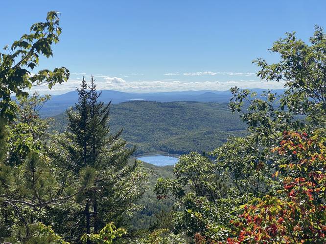
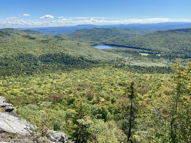
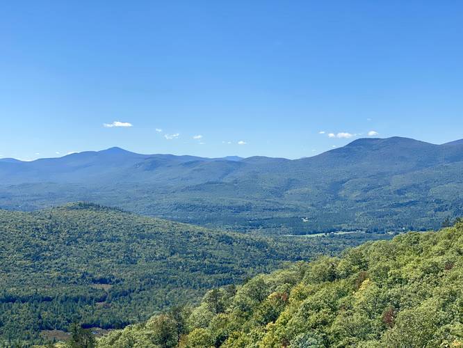
Lookout Loop Trail to Blueberry Mountain Vista
Around mile 2.87, at the top of the rocky outcropping at the summit, hikers will find yet another trailhead sign labeled "Loop". This trail is not very easy to follow, so it's best to use an offline map tracker to ensure you're still on the trail... regardless, this trail follows granite bedrock - passing through evergreens - to make your way over to a cliff with an almost-180-degree view from east to west with a mostly-southerly view. There are several spots atop this mountain cliff where hikers can enjoy the view totally alone, if you arrive early enough.
Hiking Out
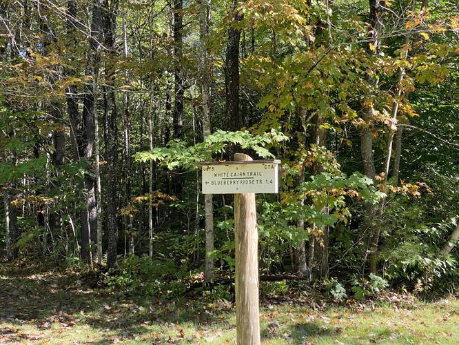
After enjoying the stunning vista atop Blueberry Mountain, it'll be time to hike out. Again, use a map and look for rock cairns to guide your way from the cliff's edge back to the Lookout Loop Trail sign. This section of the trail will include some minor granite rock climbs, no more than about 5 to 10-feet tall in most sections with gradual grades. Make your way back to the intersection with the Blueberry Ridge Trail and then hike back down along the Stone House Trail and back to parking. An alternative route would take the White Cairn Trail back to parking, but since we did not have any trekking poles for this hike, we decided to take the out-and-back hike instead of chancing steeper grades along the White Cairn Trail.
Parking
Hikers will find parking at the coordinates provided. The parking lot is large enough to fit about 5 vehicles, but even if you show up at 10AM on a Saturday, the lot will be full. Expect to park along the street itself, leaving enough room for cars to pass-by. This place is more popular than it appears - we showed up around 10AM with about 9 cars in the lot, but when we left around 2:00, there were about 25 cars parked.
Popularity
This is a popular day hike at the White Mountains, but is certainly quieter than the presidential range area.
Pets
Dogs are allowed if leashed and their waste must be carried out by the hiker.
Blaze Colors
As of September 2021, The Stone House Trail follows yellow blazes. The Blueberry Ridge Trail did not appear to have blazes in this short section. The Lookout Loop Trail follows turquoise blazes.
Trails
This hike follows several named trails: Stone House Trail, Blueberry Ridge Trail, Lookout Loop Trail (at the summit of Blueberry Mountain).
Hike Description
This trek begins at a dead end of a road located on Shell Pond Road in near Stow, Maine. The road has a large green metal gate, which is technically private property for the Stone House. Hikers must follow the rules and stay on the USFS/CTA blazed trails or the driveway at all times. The trail heads east, following the road / driveway for about 0.55-miles before hikers will reach the Stone House Trail on the left-hand side. The Stone House Trail heads up Blueberry Mountain at a very gradual grade for the first half of the trail.
The Flume
Hikers will reach a sign labeled "Gorge" around mile 0.8 - hike to the east to view the brook flume and waterfall upstream. The trails that continue on from the bridge are located on private property, so the hike heads back to the main trail after the flume.
Rattlesnake Pool with 15-foot Waterfall
Around mile 1.1 (if including the walk to and from the flume), hikers will reach another sign on the trail - this one is labeled for Rattlesnake Pool. Down this short spur trail is a beautiful emerald green swimming hole located at the base of a 15-foot waterfall. There's a steep hillside, about 15-feet tall, that hikers will have to scramble down to get a good view of the waterfall. During the heat of the Summer, this is a popular swimming spot.
Hiking to the Summit
After visiting Rattlesnake Pool and the waterfall, there's nothing left to see along this trail until the hiker reaches the top of Blueberry Mountain, around mile 2.84. The hike up is moderate, in my opinion, as the trail follows many switchbacks when it reaches the steeper grade of the mountain. The only noteworthy section of the climb up is the ~50-foot section of granite rock that the hiker must scramble up on a moderate grade. At the top, the hiker will find a steep rocky section atop the mountain - look for rock cairns, as this is the way to find the Lookout Loop Trail. Blueberry Mountain's summit is located off-trail from the Lookout Loop Trail.
Lookout Loop Trail to Blueberry Mountain Vista
Around mile 2.87, at the top of the rocky outcropping at the summit, hikers will find yet another trailhead sign labeled "Loop". This trail is not very easy to follow, so it's best to use an offline map tracker to ensure you're still on the trail... regardless, this trail follows granite bedrock - passing through evergreens - to make your way over to a cliff with an almost-180-degree view from east to west with a mostly-southerly view. There are several spots atop this mountain cliff where hikers can enjoy the view totally alone, if you arrive early enough.
Hiking Out
After enjoying the stunning vista atop Blueberry Mountain, it'll be time to hike out. Again, use a map and look for rock cairns to guide your way from the cliff's edge back to the Lookout Loop Trail sign. This section of the trail will include some minor granite rock climbs, no more than about 5 to 10-feet tall in most sections with gradual grades. Make your way back to the intersection with the Blueberry Ridge Trail and then hike back down along the Stone House Trail and back to parking. An alternative route would take the White Cairn Trail back to parking, but since we did not have any trekking poles for this hike, we decided to take the out-and-back hike instead of chancing steeper grades along the White Cairn Trail.
Parking
Hikers will find parking at the coordinates provided. The parking lot is large enough to fit about 5 vehicles, but even if you show up at 10AM on a Saturday, the lot will be full. Expect to park along the street itself, leaving enough room for cars to pass-by. This place is more popular than it appears - we showed up around 10AM with about 9 cars in the lot, but when we left around 2:00, there were about 25 cars parked.
Popularity
This is a popular day hike at the White Mountains, but is certainly quieter than the presidential range area.
Pets
Dogs are allowed if leashed and their waste must be carried out by the hiker.
Blaze Colors
As of September 2021, The Stone House Trail follows yellow blazes. The Blueberry Ridge Trail did not appear to have blazes in this short section. The Lookout Loop Trail follows turquoise blazes.