Loading...

🔥 End of Summer sale! 50% off on Supporter Accounts — now through September 1st. Learn More.

Blue Suck Falls Hike

Directions
Map
Pictures
Send to App
Distance:
8.9 Miles / 14.3 km
Type:
Loop
Difficulty:
Hard
Time to Hike:
4 hours, ~27 minutes
Features:
Surface Type:
Dirt
Town:
Clifton Forge, Virginia
Directions:
37.895361, -79.801785
Added:
April 03, 2025
Updated:
April 06, 2025
Guide by:
Copy Trail Link Hiking this trail? Send a friend or family member a link to this trail guide for your own safety. Hike at your own risk (disclaimer)
Loading...
Loading...
1,654'

Total Change
2,104'

Ascent
2,128'

Descent

Download the Trail Route for Offline Use

Supporters get exclusive access to download trail routes to the MyHikes app for offline use. Stay prepared on your adventure, even without an internet connection! Become a Supporter today to unlock this feature and hike with confidence.

Send to App

Blue Suck Falls Hike

Douthat State Park is one of Virginia's jewels. Voted as one of the nations 10 best, the park has over 43 miles of trails. With Blue Suck Falls/Tuscarora Overlook and the Beards Mountain loops, the park has two beautiful day hike circuits. The vistas and overlooks at the park are some of the best in the Old Dominion.

Although there isn't any camping on the trails in Douthat State Park, there are over 75 campsites in two camping areas near the lake, as well as a large group camp area. Douthat State Park is a great place to either tent or trailer camp for a couple of days, and hike the multiple loops available in the valley.

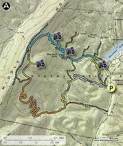
  • Mile 0.0 - From the parking area cross Wilson Creek on a paved road, then shortly pass the Beards Gap Hollow Trail that will be the return route. Continue up the paved road and in 100 yards enter the main section of the Campground.
  • Mile 0.2 - Turn left uphill on the yellow blazed Tobacco Ridge Trail and in 0.5 miles reach the high point of the trail and a overlook of Douthat Lake. Continue along Tobacco Ridge Trail for another 0.5 miles as it descend to the intersection of the blue blazed Blue Suck Falls Trail.
  • Mile 1.2 - Turn left uphill on the blue blazed Blue Suck Falls trail immediately crossing a stream and in 200 yards pass the green blazed Huffs Trail on the right. 0.2 miles from the Huffs Trail intersection reach the intersection of the Laurel View Trail on the right. Stay left remaining on the blue blazed Blue Suck Falls Trail and in 0.5 miles pass the yellow blazed Locust Gap Trail that comes in from the left. Turn right on the blue blazed Blue Suck Falls trail is it becomes steeper and rockier for the next 0.3 miles before arriving at Blue Suck Falls.
  • Mile 2.2 - Continue uphill on the Blue Suck Falls Trail for 0.3 miles where the Blue suck Falls Trail turns left uphill, and the yellow blazed Pine Tree Trail continues straight.
  • Mile 2.3 - Turn left remaining on the blue blazed trail as it switchbacks steeply up Middle Mountain passing several beautiful overlooks before reaching Overlook Rock, and vista of the valley and Lake Douthat. Continue uphill on the Blue Suck Falls Trail as it switchbacks four more times before arriving at the yellow blazed Tuscarora Overlook Trail in 0.9 miles.
  • Mile 3.4 - Turn left downhill on the yellow blazed trail passing the intersection of the Tuscarora Overlook Trail continuation in 0.3 miles, and reaching a small cabin at the Tuscarora Overlook in another 0.1 miles.
  • Mile 3.8 - From Tuscarora Overlook, return back to the last intersection and turn left on the yellow blazed continuation of the Tuscarora Overlook Trail. In 0.5 miles the yellow blazed trail ends at the orange blazed Stony Run Trail.
  • Mile 4.3 - Turn left downhill on the orange blazed trail as it makes eight sharp switchbacks before passing through a thick area of rhododendron and crossing Stony Run in 2.1 miles.
  • Mile 6.4 - Continue downward on the Stony Run Trail, passing a blue blazed trail on the right, re-crossing Stony Run and then arriving at the intersection of the yellow blazed Locust Gap Trail.
  • Mile 7.3 - Turn left slightly uphill on the yellow blazed trail as it winds around the valley reaching the silver blazed Beards Gap Hollow Trail in 1.1 miles.
  • Mile 8.4 - The yellow blazed Locust Gap Trail turns left uphill, and the silver blazed Beards Gap Hollow Trail turns right downhill. Turn right downhill on the Beards Gap Hollow Trail for 0.9 miles where it veers right onto a gravel road. In 200 yards after joining the gravel road arrive back at the paved road for the Campground. Stay right re-crossing Wilson Creek.
  • Mile 9.4 - Arrive back at the parking area.
Explore 24 trails near Clifton Forge, VA
  1. Parking

    37.895361, -79.801785
  2. Main Trailhead

    37.895717, -79.804173
No community routes found. To add your own hike as a Community Route for this Trail guide, leave a Trip Report with an attached GPX file.

Hazards

Ticks - Lyme Disease More Info (CDC)
Snakes
Poison Ivy/Oak

Seasons

All

Photo Albums

+ Add Photo Album

Upload your photos from the trail to help others know what to expect.

Trip Reports (Reviews)

Rated 4.43 out of 5 based on 14 ratings.
By: Don Mac
8.9 miles / 14.3 km
July 13, 2016
This hike was fantastic! Kudos to Virginias DCR for well kept and clearly marked trails. It was quite warm when we hiked this but nearly all of the hike was shaded. Do not pass up the views at the Tuscarora overlook and its cabin! It was a long hike as our monitor device indicated 12 miles but whatever it was it was worth it! I would be prepared for deeper water on the stream crossings if you do this during a rainy spell.
Legacy Review
By: Jeff
8.9 miles / 14.3 km
July 09, 2016
Hiked this on a warmish afternoon, found it to be wonderful. Starts with a half-mile uphill right off the bat, which was difficult for not-yet-warmed up legs, but I was able to settle in before making the climb up to the falls. The quarter-mile of the Blue Suck Falls trail was the steepest pitch of the whole hike, with about 150' directly in the creek bed, and would probably be difficult the day after a big rain. After the falls, the trail climbs a dozen switchbacks up Middle Mountain, with rest benches made of stone on the second and sixth switchback. The Tuscarora trail was in good condition, though close to being overgrown in a couple of spots there was no danger of ever losing the trail. Descending on the Stony Run trail was a nice cruise down mellow grades. Right after the trail crosses Stony Run Creek in the rhododendron stand, you can bear right 300' on a bandit trail to another pleasant waterfall. Closing the loop is mostly flat hiking with a couple of minor creek crossings. Look to the left after turning onto Beards Gap trail to see a some recently-burned forest. I saw two families and one solo hiker, and one mountain biker on this trip. Of note, while Blue Suck, Tuscarora, and portions of Stony Run are closed to horseback travel according to signs on the trail, I saw enough hoofprints and horse apples to make it worth keeping an eye out. Also, the forest canopy was pretty open on some parts of this hike and I caught more sun than I was expecting. Doing this hike on a really hot day would be a challenge between the sun and the climbing.
Legacy Review
By: KarenNDkitchen
8.9 miles / 14.3 km
August 26, 2014
I have to agree with the other reviewers, this is one terrific hike. A little strenuous but many places to stop, rest, and take in the view - esp. Tuscarora Overlook! Blue Suck Falls was barely a trickle, which was a little surprising because it rained for a few days before. The trails are well-maintained, except for a few signs (an arrow pointing straight ahead to get to Blue Suck Falls Trail when in fact the trail turned either left or right. Also confusing signs near Tuscarora Overlook. Don't forget your awesome Hiking Upward Map :) ) We passed only one guy on a mountain bike the whole time.
Legacy Review

Weather Forecast

In Clifton Forge, VA

Explore Hiking Trails

You May Also Like

New York's Best Waterfalls - Whether you're planning a day hike, roadside stop, or a leisurely short walk, this guide provides hikers, travelers, and locals alike with 63 different locations to over 100 scenic waterfalls to help plan your next adventure!
Explore

New York's Best Waterfalls

Whether you're planning a day hike, roadside stop, or a leisurely short walk, this guide provides hikers, travelers, and locals alike with 63 different locations to over 100 scenic waterfalls to help plan your next adventure!

Read
25 Best Day Hikes in North Carolina - Discover the top 25 best day hikes in North Carolina, from breathtaking waterfalls to mountain peaks. Explore hidden gems, scenic views, and trails suitable for all skill levels, perfect for your next outdoor adventure.
Explore

25 Best Day Hikes in North Carolina

Discover the top 25 best day hikes in North Carolina, from breathtaking waterfalls to mountain peaks. Explore hidden gems, scenic views, and trails suitable for all skill levels, perfect for your next outdoor adventure.

Read

Before you boogie...

Find our trail guides useful? Consider becoming a Supporter to unlock perks!

MyHikes is an indie platform that makes exploring public trails easier for everyone. The platform has no investors, no ads, and is owned and operated by one person, Dave Miller. Dave has personally mapped and written over 1,800 trail guides on MyHikes for the public to explore. MyHikes has helped millions outdoor enthusiasts plan their next adventure.

But it takes a lot of time 🕦, money 💰, work, and espresso shots ☕ to run MyHikes, including hiking , mapping , writing , and publishing new trails with high-quality (accurate) information... along with software engineering (coding) the platform like building new features, website and mobile app development (iOS and Android), site maintainance . and much much more.

Supporters unlock website and mobile app perks with an annual one-time payment of $25 (you renew) 😎👍. Or you can simply make a Donation of your choice. Otherwise, you can support us by telling your friends about MyHikes - both quick and free 🎉

Admin user profile picture

Dave Miller
MyHikes Founder