Loading...

๐ŸŽ† 50% off 4th of July sale on Supporter Accounts โ€” now through July 6! Learn More.

Blakiston Falls Trail

Directions
Map
Pictures
Send to App
Distance:
1.9 km / 1.2 Miles
Type:
Out-and-Back
Difficulty:
Easy
Time to Hike:
~36 minutes
Features:
Surface Type:
Dirt
Park:
Waterton Lakes National Park
Town:
Waterton Park, Alberta - Canada
Directions:
49.130266, -114.026432
Added:
September 18, 2024
Updated:
September 29, 2024
Copy Trail Link Hiking this trail? Send a friend or family member a link to this trail guide for your own safety. Hike at your own risk (disclaimer)
Loading...
Loading...
35m

Total Change
51m

Ascent
49m

Descent

Download the Trail Route for Offline Use

Supporters get exclusive access to download trail routes to the MyHikes app for offline use. Stay prepared on your adventure, even without an internet connection! Become a Supporter today to unlock this feature and hike with confidence.

Send to App

Blakiston Falls Trail

The Blakiston Falls Trail at Waterton Lakes National Park near Waterton Park. Alberta is an easy 1.9 km out-and-back hike that leads to two viewpoints of the multi-tiered waterfall, Blakiston Falls.

Hiking to Blakiston Falls

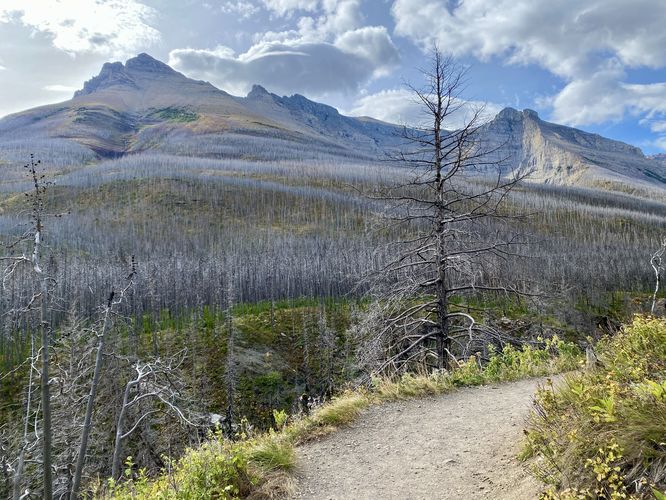
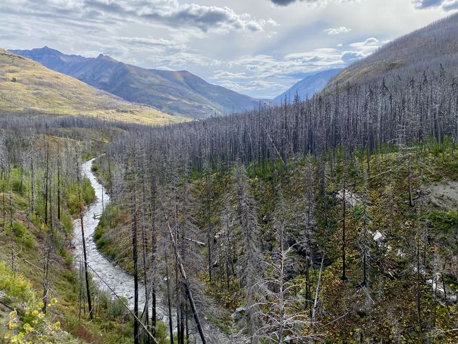
This hike begins at the southern end of the Red Rock Canyon Loop where you'll find the trailhead and a footbridge that spans Bauerman Creek. The trail heads into the forest as it gradually heads uphill toward the Blakiston Falls lookout points. Hikers will notice a forest of dead standing evergreen trees that burned in the 2017 September wildfire -- leaving the forest wide-open to sunlight and full of dead trees. This forest is healing, but rebuilding with countless saplings, shrubs, and other vegetation thriving on the forest floor. During very windy days, hikers might want to reconsider this trail as the danger of falling trees increases; however, these dead standing trees can and do fall randomly all the time, so be mindful and pay attention to the forest as you traverse the trail. Around 0.75 km, hikers will reach a section of trail that includes an adjacent steep slope where you'll find views of Mount Blakiston, Blakiston Creek, and eventually Blakiston Falls located upstream.

Lower Blakiston Falls Overlook - 0.85 km

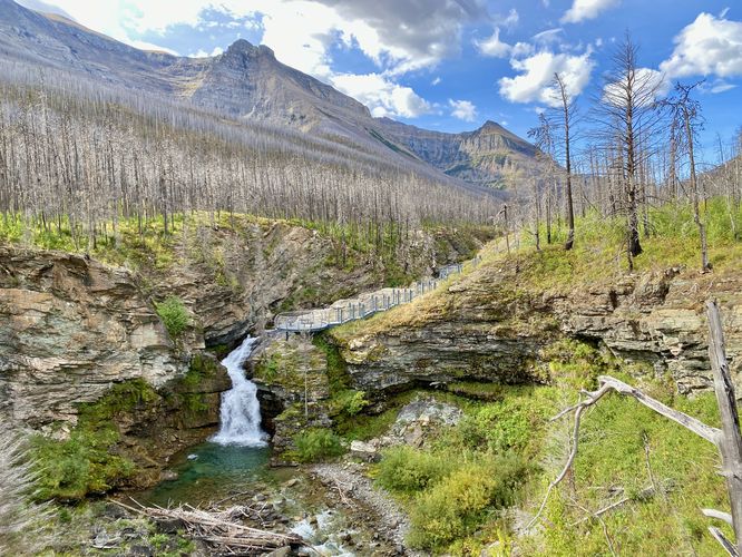
At 0.85 km from the trailhead, hikers will reach the first metal walkway that juts out high above Blakiston Creek to provide hikers with the best downstream view of Blakiston Falls. From here, you can appreciate the turquoise-colored pool that sits below the waterfall and is by-far the best view of the cascade along the hike. The views aren't over though, the next stop is located just up the trail to take-in views of Upper Blakiston Falls and the top of the lower cascade.

Upper Blakiston Falls - 0.95 km

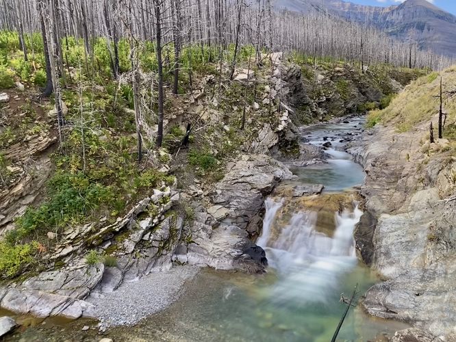
The trail continues southwest to reach the second metal walkway that leads hikers out to the top of Blakiston Falls. Along the way, the first stop on this metal walkway is a nice viewpoint of Upper Blakiston Falls. This short, but scenic cascade, spills down the bedrock along a slide waterfall where, at the base, its pool of water sits above the light-colored bedrock -- making for another stunning waterfall view with turquoise-like waters below.

Top of Blakiston Falls - 0.98 km

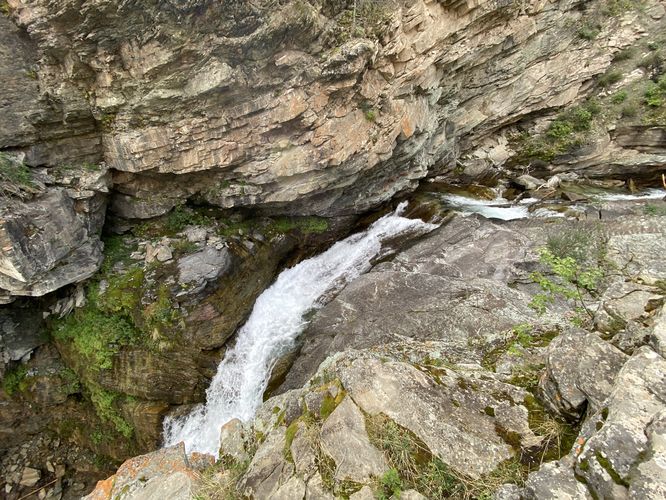
At the end of the metal walkway is the last viewpoint at Blakiston Falls -- the top of the waterfall. While hikers can get a nice view of the surrounding area from this viewpoint, the view from the top of Blakiston Falls is certainly not a nice as the downstream view; however, if you plan to explore the Upper Blakiston Falls section of the hike, you might as well check out the top of the main waterfall while you're right next door. The top of Blakiston Falls rushes through a skinnier rock "gorge" below your feet before it swoops down and into the turquoise pool below.

After exploring all viewpoints along the trail, the hike back is a quick and easy 1 km walk back to reach the trailhead.

Parking

Hikers will find a large parking lot at the coordinates provided at the end of Red Rock Parkway. The lot is large enough to fit several dozen vehicles as of September 2024.

Pets

Dogs are allowed only if leashed and must be cleaned up after.

Fees

As of September 2024, there's a $11/adult entrance fee to get into Waterton Lakes National Park.
Explore 15 trails near Waterton Park, AB
  1. Parking

    49.130266, -114.026432
  2. Main Trailhead

    49.129529, -114.02835
  3. View of Mount Blakiston

    49.127033, -114.034758
    View of Mount Blakiston
  4. Blakiston Falls viewpoint

    49.126439, -114.035606
    Blakiston Falls viewpoint
  5. Upper Blakiston Falls

    49.126019, -114.036292
    Upper Blakiston Falls
  6. Top of Blakiston Falls

    49.125947, -114.035933
    Top of Blakiston Falls
  7. View of Blakiston Creek

    49.126797, -114.035217
    View of Blakiston Creek
No community routes found. To add your own hike as a Community Route for this Trail guide, leave a Trip Report with an attached GPX file.

Hazards

Rockfalls / Ledges / or Scrambles

Seasons

All

Trip Reports

Trail Guide By:
Admin user profile picture
1.2 miles / 1.9 km
1.2 miles / 1.9 km
September 18, 2024
Beautiful waterfalls with colorful pools of water at the base of each
Hiking

Weather Forecast

In Waterton Park, AB

Explore Hiking Trails

You May Also Like

Colorado's Million Dollar Highway - Plan a day's drive adventure along the iconic Million Dollar Highway in Colorado. Explore the best short trails, roadside stops, waterfalls, vistas, ghost towns, and hot springs within a ~6 hour road trip.
Explore

Colorado's Million Dollar Highway

Plan a day's drive adventure along the iconic Million Dollar Highway in Colorado. Explore the best short trails, roadside stops, waterfalls, vistas, ghost towns, and hot springs within a ~6 hour road trip.

Read
Glacier's Going-to-the-Sun Road - Discover the breathtaking beauty of Glacier National Park along the iconic Going-to-the-Sun Road. From stunning roadside stops to picturesque waterfalls and vistas, this engineering marvel offers endless opportunities for exploration.
Explore

Glacier's Going-to-the-Sun Road

Discover the breathtaking beauty of Glacier National Park along the iconic Going-to-the-Sun Road. From stunning roadside stops to picturesque waterfalls and vistas, this engineering marvel offers endless opportunities for exploration.

Read
New York's Best Waterfalls - Whether you're planning a day hike, roadside stop, or a leisurely short walk, this guide provides hikers, travelers, and locals alike with 63 different locations to over 100 scenic waterfalls to help plan your next adventure!
Explore

New York's Best Waterfalls

Whether you're planning a day hike, roadside stop, or a leisurely short walk, this guide provides hikers, travelers, and locals alike with 63 different locations to over 100 scenic waterfalls to help plan your next adventure!

Read

Before you boogie...

Find our trail guides useful? Consider becoming a Supporter to unlock perks!

MyHikes is an indie platform that makes exploring public trails easier for everyone. The platform has no investors, no ads, and is owned and operated by one person, Dave Miller. Dave has personally mapped and written over 1,800 trail guides on MyHikes for the public to explore. MyHikes has helped millions outdoor enthusiasts plan their next adventure.

But it takes a lot of time ๐Ÿ•ฆ, money ๐Ÿ’ฐ, work, and espresso shots โ˜• to run MyHikes, including hiking , mapping , writing , and publishing new trails with high-quality (accurate) information... along with software engineering (coding) the platform like building new features, website and mobile app development (iOS and Android), site maintainance . and much much more.

Supporters unlock website and mobile app perks with an annual one-time payment of $25 (you renew) ๐Ÿ˜Ž๐Ÿ‘. Or you can simply make a Donation of your choice. Otherwise, you can support us by telling your friends about MyHikes - both quick and free ๐ŸŽ‰

Admin user profile picture

Dave Miller
MyHikes Founder