Loading...

Distance:
5.1 Miles / 8.2 km
Type:
Out-and-Back
Difficulty:
Moderate
Time to Hike:
2 hours, ~33 minutes
Features:
Surface Type:
Dirt
Park:
Shasta-trinity National Forest
Town:
Mount Shasta, California
Directions:
41.372848, -122.340016
Added:
February 17, 2017
Updated:
February 11, 2020
Loading...
Loading...
1,812 '

Total Change
1,549 '

Ascent
0 '

Descent

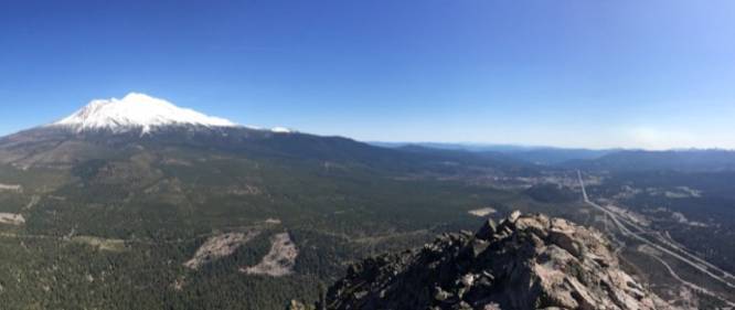
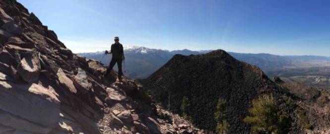
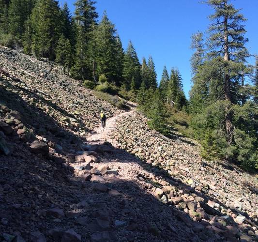
The trail up Black Butte is 5.2-ish miles (roundtrip) with an elevation gain of about 2000 feet. It’s rocky, but nicely graded. From the top, you’ll have incredible views: Mount Shasta to east, Castle Crags to the south and Mount Eddy to the west. You can also see a snowy Cascade up in Oregon, 70 miles to the north. Access to the trailhead is along a gravel road. It may be snowbound in the winter.

For more detailed directions, check out this link.

For more details about this trip, check out the Black Butte Norcalhiker post.

Explore 3 trails near Mount Shasta, CA
  1. Parking

    41.372848, -122.340016
  2. Main Trailhead

    41.372684, -122.340674
  3. View from the summit of Black Butte

    41.366547, -122.348122
    View from the summit of Black Butte
  4. Vista point just below the summit

    41.367808, -122.349381
    Vista point just below the summit
  5. Steep elevation grade heading up the mountain

    41.372864, -122.346022
    Steep elevation grade heading up the mountain
No community routes found. To add your own hike as a Community Route for this Trail guide, leave a Trip Report with an attached GPX file.

Hazards

Ticks - Lyme Disease More Info (CDC)

Season

Summer

Photo Albums

1 Trip Report

No Star-Ratings
Trail Guide By:
Norcalhiker user profile picture
5.1 miles / 8.2 km
Trail added
February 17, 2017
Hiked on
February 17, 2017
Updated on
February 11, 2020

Weather Forecast

In Mount Shasta, CA

Explore Hiking Trails

New Hikes

Estes Park Riverwalk
0.9 Miles
1.4 km
Easy
Out-and-Back
Lake Estes Trail
0.9 Miles
1.4 km
Easy
Out-and-Back
Gorge Trail (Stony Brook)
0.8 Miles
1.3 km
Moderate
One-Way
Hidden Valley Nature Trail
0.7 Miles
1.1 km
Easy
Loop

Before you boogie...

Find our trail guides useful? Consider becoming a Supporter to unlock perks!

MyHikes is an indie platform that makes exploring public trails easier for everyone. The platform has no investors, runs no ads, and is owned and operated by one person, Dave Miller. Dave has personally mapped and written over 1,600 trail guides on MyHikes for the public to explore. As of 2024, MyHikes has helped over 1,300,000 outdoor enthusiasts plan their next adventure.

But it takes a lot of time 🕦, money 💰, and work, and espresso shots ☕ to run MyHikes, including hiking , mapping , writing , and publishing new trails with high-quality (accurate) information... along with software engineering (coding) the platform like building new features, site and mobile app development for iOS and Android, site maintainance . and much much more.

Supporters unlock website and mobile app perks with an annual one-time payment of $25 (you renew) 😎👍. Or you can simply make a Donation of your choice. Otherwise, you can support us by telling your friends about MyHikes - both quick and free 🎉

Admin user profile picture

Dave Miller
MyHikes Founder