Loading...

๐ŸŽ† 50% off 4th of July sale on Supporter Accounts โ€” now through July 6! Learn More.

Birdsong Fairy Trail

Directions
Map
Pictures
Send to App
Distance:
0.8 Miles / 1.3 km
Type:
Loop
Difficulty:
Easy
Time to Hike:
~24 minutes
Surface Type:
Dirt
Park:
Mendon Ponds Park
Town:
Henrietta, New York
Directions:
43.022182, -77.583034
Added:
May 14, 2023
Updated:
May 18, 2023
Copy Trail Link Hiking this trail? Send a friend or family member a link to this trail guide for your own safety. Hike at your own risk (disclaimer)
Loading...
Loading...
66'

Total Change
93'

Ascent
95'

Descent

Download the Trail Route for Offline Use

Supporters get exclusive access to download trail routes to the MyHikes app for offline use. Stay prepared on your adventure, even without an internet connection! Become a Supporter today to unlock this feature and hike with confidence.

Send to App

Birdsong Fairy Trail

The Birdsong Fairy Trail at Mendon Ponds Park near Henrietta, New York is an easy 0.8-mile loop trail that features a neat fairy and troll forest walk.

Walk Description
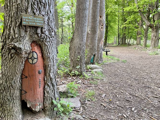
This is less of a hike and more of an easy forest walk; however, the Birdsong Fairy Trail is a unique place to explore near Rochester, New York due to its plentiful and colorful mixture of fairy houses. Visitors will begin at the main parking lot at the Wild Wings Nature Center at the park. Walk from the entrance and southeast to reach a trail junction and trailhead sign for the Birdsong Fairy Trail. The fairy houses can be found along this route. The Birdsong Fairy Trail encompasses this small square of trails, so take a left-hand turn at each trail junction to head back to parking.

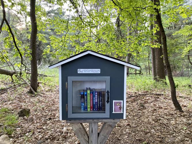
Along the way, walkers will find ~30 different fairy houses along with a handful of wildlife blinds for viewing birds or deer. There's even a Little Free Library located at mile 0.2. The fairy houses will end (as of May 2023) around mile 0.45 at the 2nd left-hand turn in the loop.

Parking Hikers will find a large parking lot at the Wild Wings Nature Center at the coordinates provided.

Pets
Dogs are not allowed on this trail.
Explore 12 trails near Henrietta, NY
  1. Parking

    43.022182, -77.583034
  2. Main Trailhead

    43.022182, -77.583034
  3. Fairy house

    43.020664, -77.582328
    Fairy house
  4. Little Free Library

    43.020431, -77.582358
    Little Free Library
No community routes found. To add your own hike as a Community Route for this Trail guide, leave a Trip Report with an attached GPX file.

Hazards

Ticks - Lyme Disease More Info (CDC)

Seasons

All

Weather Forecast

In Henrietta, NY

Explore Hiking Trails

You May Also Like

Colorado's Million Dollar Highway - Plan a day's drive adventure along the iconic Million Dollar Highway in Colorado. Explore the best short trails, roadside stops, waterfalls, vistas, ghost towns, and hot springs within a ~6 hour road trip.
Explore

Colorado's Million Dollar Highway

Plan a day's drive adventure along the iconic Million Dollar Highway in Colorado. Explore the best short trails, roadside stops, waterfalls, vistas, ghost towns, and hot springs within a ~6 hour road trip.

Read
Glacier's Going-to-the-Sun Road - Discover the breathtaking beauty of Glacier National Park along the iconic Going-to-the-Sun Road. From stunning roadside stops to picturesque waterfalls and vistas, this engineering marvel offers endless opportunities for exploration.
Explore

Glacier's Going-to-the-Sun Road

Discover the breathtaking beauty of Glacier National Park along the iconic Going-to-the-Sun Road. From stunning roadside stops to picturesque waterfalls and vistas, this engineering marvel offers endless opportunities for exploration.

Read
New York's Best Waterfalls - Whether you're planning a day hike, roadside stop, or a leisurely short walk, this guide provides hikers, travelers, and locals alike with 63 different locations to over 100 scenic waterfalls to help plan your next adventure!
Explore

New York's Best Waterfalls

Whether you're planning a day hike, roadside stop, or a leisurely short walk, this guide provides hikers, travelers, and locals alike with 63 different locations to over 100 scenic waterfalls to help plan your next adventure!

Read

Before you boogie...

Find our trail guides useful? Consider becoming a Supporter to unlock perks!

MyHikes is an indie platform that makes exploring public trails easier for everyone. The platform has no investors, no ads, and is owned and operated by one person, Dave Miller. Dave has personally mapped and written over 1,800 trail guides on MyHikes for the public to explore. MyHikes has helped millions outdoor enthusiasts plan their next adventure.

But it takes a lot of time ๐Ÿ•ฆ, money ๐Ÿ’ฐ, work, and espresso shots โ˜• to run MyHikes, including hiking , mapping , writing , and publishing new trails with high-quality (accurate) information... along with software engineering (coding) the platform like building new features, website and mobile app development (iOS and Android), site maintainance . and much much more.

Supporters unlock website and mobile app perks with an annual one-time payment of $25 (you renew) ๐Ÿ˜Ž๐Ÿ‘. Or you can simply make a Donation of your choice. Otherwise, you can support us by telling your friends about MyHikes - both quick and free ๐ŸŽ‰

Admin user profile picture

Dave Miller
MyHikes Founder