Loading...

🔥 End of Summer sale! 50% off on Supporter Accounts — now through September 1st. Learn More.

Billy Goat Trail Hike

Directions
Map
Pictures
Send to App
Distance:
7.3 Miles / 11.7 km
Type:
Loop
Difficulty:
Moderate
Time to Hike:
3 hours, ~39 minutes
Features:
Surface Type:
Dirt
Town:
Potomac, Maryland
Directions:
39.002241, -77.246641
Added:
March 20, 2025
Updated:
April 06, 2025
Guide by:
Copy Trail Link Hiking this trail? Send a friend or family member a link to this trail guide for your own safety. Hike at your own risk (disclaimer)
Loading...
Loading...
185'

Total Change
462'

Ascent
464'

Descent

Download the Trail Route for Offline Use

Supporters get exclusive access to download trail routes to the MyHikes app for offline use. Stay prepared on your adventure, even without an internet connection! Become a Supporter today to unlock this feature and hike with confidence.

Send to App

Billy Goat Trail Hike

The Billy Goat Trail is one of the most well known hikes in the Metro D.C. area, and for good reason. With nearly a mile of fun rock-hopping, and spectacular views of the Potomac River along the way, this circuit is loads of fun with plenty to see. We have the circuit rated as only a for difficulty, but be prepared to jump from rock to rock.

The Billy Goat Trail is very busy on nice days anytime of the year, however if you get on the trail by 8:00 a.m. you can miss all the crowds. The entire Billy Goat Trail is made up of 3 separate sections A, B, & C, that start and finish on the C&O Canal. The 7.8 mile circuit we have mapped here follows the rock-hopping section A, the more casual hike on section B, with a return back to the Great Falls parking area using the Berma Rd. Trail and Overlook Trail.

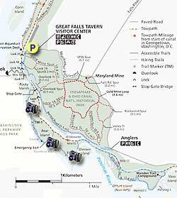
  • Mile 0.0 – From the parking area at Great Falls Park follow the path past the Great Falls Tavern and Visitors Center, cross over to the C&O Canal at Lock 19, then follow the C&O canal down to the entrance for the Billy Goat A Trail 50 yards before the covered Stop Gate.
  • Mile 0.9 - Turn right onto the Billy Goat A Trail where shortly it starts paralleling the Potomac River. The Potomac River is approximately 50ft below at this point. From here the trail becomes more of a rock-hop then arrives at Trail Marker 1.
  • Mile 1.4 - Trail Marker 1 is the point where the rock-hopping becomes more intense. There is a National Park sign warning hikers that 'Many hikers are injured every year on this section of the Billy Goat A Trail' so be prepared for a little more scrabbling. Between Markers 1 and 2 you also need to climb the 50ft traverse mentioned on the Trail Marker 1 sign. Although this might look slightly intimidating to some people, once on the traverse it's not that difficult.
  • Mile 1.9 - From Trail Marker 2 the scrambling diminishes, and the trail descends to the river bank where there is a nice beach area. DO NOT be tempted to wade into the water as the currents are deceptively strong, and you can be quickly washed down stream. Continue along the trail passing a wetland, small pond, then crossing a small log bridge. On the opposite side of the log bridge is Trail Marker 3.
  • Mile 2.2 - From Trail Marker 3 there is one more spectacular panorama of the Potomac River before the trail becomes more gentle passing by Sherwin Island and arriving back at the C&O Canal.
  • Mile 2.5 - Turn right on the C&O Canal following it for 0.6 miles to the entrance of the Billy Goat B Trail.
  • Mile 2.8 - Turn right on the Billy Boat B Trail. The trail is considerably more leisurely than the Billy Goat A Trail, with only a small section of rock-hopping where the trail passes Hermit Island. Where the Potomac River passes Hermit Island is a favorite spot for Paddle Boarders surfing the river wakes. Continue on the trail passing the Marsden Tract Campground, then arrive back at the C&O Canal.
  • Mile 4.4 - Now turn left on the C&O Canal heading back towards Great Falls. In 1.1 miles reach the Anglers Parking Area bridge over the C&O Canal.
  • Mile 5.5 - Cross the Anglers parking area bridge and ascend the wooden steps to the Berma Rd Trail. Turn left on the Berma Rd Trail for 1.4 miles to the intersection of the white blazed Overlook Spur Trail.
  • Mile 6.9 - Turn right uphill on the Overlook Spur Trail for 120 yards to the intersection of the yellow blazed Overlook Trail. Turn Left on the Overlook Trail. You will pass a unmarked side trail to an overlook of Great Falls, then continue to the main overlook at a switchback on the trail. Continue now downhill to the Lock 19 Trail intersection.
  • Mile 7.1 - Turn left at the Lock 19 Trail and follow it back down to the main Great Falls Park area. Continue past the Great Falls Tavern and Visitors Center back to the parking area.
  • Mile 7.3 - Arrive back at the parking area.
Explore 19 trails near Potomac, MD
  1. Parking

    39.002241, -77.246641
  2. Main Trailhead

    39.00156, -77.247298
No community routes found. To add your own hike as a Community Route for this Trail guide, leave a Trip Report with an attached GPX file.

Seasons

All

Trip Reports (Reviews)

Rated 4.17 out of 5 based on 29 ratings.
By: Sonal
7.3 miles / 11.7 km
April 14, 2018
If you enjoy long walks/hikes in nature, and hate driving/don't have time for Shenandoah, then Billy Goat Trail is perfect for you. I've been here 4 times in 7 months. So far, every season has presented a different look of this trail, and I've loved it every time. Whether you're watching geese in the river, dogs strolling along, kids scampering all over, or are just one of the several people navigating the 50 ft cliff, this place gives ample opportunities to connect with nature despite the crowds. My favorite thing about it is that it is short enough to squeeze it into a workday, strenuous enough to break a sweat, countless spots to take a break, and beautiful views to keep you going!
Legacy Review
By: Randy Causey
7.3 miles / 11.7 km
July 16, 2017
Flat out... my favorite hike. With over 1700 legs of the "A" Trail in 16 years, I may know Bear Island better than the deer or foxes. There is NO better hike within 70 miles of Washington, DC in any direction. This is where you come to sweat, get scraped up and commune with nature. Here I would like to ask that all the potential hikers who check in here, please observe a certain amount of courtesy for the trail and other hikers. Also, RESPECT the trail. It is DANGEROUS! Over a dozen lives a year are lost out here by those who are either ill equipped, out of condition or inattentive to the terrain. Please use adequate footware. Cabin John VFD River Rescue respond to over 100 calls per year for orthopedic injuries or exhaustion. I've seen them have 3 separate calls in one day during the spring and summer on weekends. This is NOT the place to bring mom for beautiful stroll into nature. Take her to a restaurant. Now for those who wish to hike the trail. Please don't show up with more than 4 or 5 to your party. Much of the trail is single passage. Traffic runs both ways. Be considerate to the other hikers who arrive in 1s and 2s. Also parties of 4 or more typically travel much slower and make a lot of noise. There are foxes out here that may be visible to the quiet. Hognose snakes can be heard to "hiss" when near if you are quiet. Snappers can hear people 40 yards away and just disappear until the quiet returns. You also want to hear the Piliated Woodpecker which sounds like "Jungle Monkeys" out here. Please stay out of the water, as it is a CFR VIOLATION and fine. It's also a major cause for the loss of life out here. And no one wants to see this place closed off to the public. I would also recommend that headphones/ear buds be put away. Stay off of phones unless stopped. You need all of your senses in gear as there are not two flat areas next to each other out here. Its too easy to roll an ankle out here when talking, looking behind or just not paying attention to exactly where one is stepping. One small piece of advice, upon approach to Purple Horse Beach, note that the rocks here are more weathered and rounded. They are the slippery even when dry. Also note these same rocks are darker than anywhere else around here. They have been in the sun all day and radiate heat. It is a giant sauna bath. Many approach heat exhaustion in this area. This is "Ground Zero" for Cabin John River Rescue on emergency calls. It is also typically the place where bodies will wash up of those who were stupid enough to jump off the cliffs. Please, enjoy the BGT "A". Respect it and the other hikers who have come to love this small area of paradise. All of Bear Island is one big rock, so please be careful as any slip has the potential to be critical. Getting off my soap box now. I love this place. Hope to see you out here.
Legacy Review
By: Suzanne
7.3 miles / 11.7 km
June 24, 2017
First time doing the Billy Goat A trail from beginning to end. The 50 foot wall is a challenge but doable. If you like rock hopping you will love this hike. Stunning views! I went on a Saturday afternoon and while there were many people on my he trail I was hadn't call for t crowded. Very little waiting time. Next time I'll wear my gloves.
Legacy Review

Weather Forecast

In Potomac, MD

Explore Hiking Trails

You May Also Like

Colorado's Million Dollar Highway - Plan a day's drive adventure along the iconic Million Dollar Highway in Colorado. Explore the best short trails, roadside stops, waterfalls, vistas, ghost towns, and hot springs within a ~6 hour road trip.
Explore

Colorado's Million Dollar Highway

Plan a day's drive adventure along the iconic Million Dollar Highway in Colorado. Explore the best short trails, roadside stops, waterfalls, vistas, ghost towns, and hot springs within a ~6 hour road trip.

Read
New York's Best Waterfalls - Whether you're planning a day hike, roadside stop, or a leisurely short walk, this guide provides hikers, travelers, and locals alike with 63 different locations to over 100 scenic waterfalls to help plan your next adventure!
Explore

New York's Best Waterfalls

Whether you're planning a day hike, roadside stop, or a leisurely short walk, this guide provides hikers, travelers, and locals alike with 63 different locations to over 100 scenic waterfalls to help plan your next adventure!

Read

Before you boogie...

Find our trail guides useful? Consider becoming a Supporter to unlock perks!

MyHikes is an indie platform that makes exploring public trails easier for everyone. The platform has no investors, no ads, and is owned and operated by one person, Dave Miller. Dave has personally mapped and written over 1,800 trail guides on MyHikes for the public to explore. MyHikes has helped millions outdoor enthusiasts plan their next adventure.

But it takes a lot of time 🕦, money 💰, work, and espresso shots ☕ to run MyHikes, including hiking , mapping , writing , and publishing new trails with high-quality (accurate) information... along with software engineering (coding) the platform like building new features, website and mobile app development (iOS and Android), site maintainance . and much much more.

Supporters unlock website and mobile app perks with an annual one-time payment of $25 (you renew) 😎👍. Or you can simply make a Donation of your choice. Otherwise, you can support us by telling your friends about MyHikes - both quick and free 🎉

Admin user profile picture

Dave Miller
MyHikes Founder