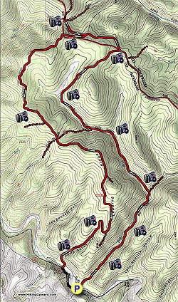
Start the hike by crossing Gandy Creek over the footbridge and start up the Big Run Trail, paralleling Big Run on your right. Remember you will follow the blue diamonds for most of this two-day hike. Over the next 1.6 miles cross back and forth over Big Run six times before finally crossing North Prong and coming to a small clearing with the North Prong Trail coming in from the left.
Proceed left up the North Prong Trail, where you will pass several clearings and cross the run three times before passing the Eliza Trail coming in from the left at 2.2 miles from the last junction. At this point, continue following the blue blazes and triangles as the trail gets steeper. 1.9 miles after taking the North Prong trail, you will come to a large meadow, stay on the right and continue up the trail to a ridge clearing at 2.5 miles. Stay to the left and go another .2 miles to the intersection of the Allegheny Trail. Just before the Allegheny Trail junction a small trail will come in from the left, bypass this and continue 50 yards to the junction.
Turn left on the Allegheny Trail passing a small clearing on your left. In .5 miles pass the leading Ridge Trail that comes in from your left, you will take this on the way back. .7 miles after getting on the Allegheny Trail pass a small pond and spring on your right, this is your closest source of water from the camp sight that will be .2 miles further on the left opposite a ridge line clearing. Start your second day by hiking .4 miles back the junction of the Leading Ridge Trail and turn right.
The return hike on day two on the Leading Ridge Trail should only take about 3.5 hours. Follow the blue diamonds for the Leading Ridge Trail the entire way back to Gandy Creek, passing the Bea Trail on your right at 2.4 miles and the Elza on your left at 3.1 miles. After starting your main descent, the road will fork at 4.7 miles. Take the blue diamond trail that swings to your right and continue downward with a small stream on your right at 4.9 miles then going through a rhododendron patch at 5.5 miles. In another .2 miles, you will come to Gandy Creek, cross over the footbridge go up to the road and turn left. In .3 miles the parking lot you departed from the day before will be on your left.