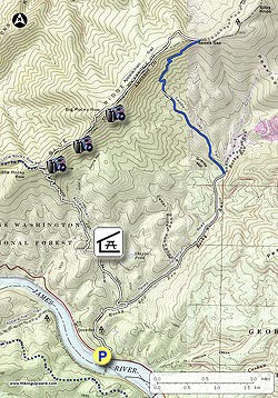
Ever wonder where the James River goes through the Blue Ridge Mountains? Do this hike and you'll see it. The hike starts at the $2.0M Appalachian Trail James River Foot Bridge. Once on the ridge you will have multiple awesome views of the James River cutting its way through the mountains, the geological term for this is water gap.
We have mapped this as a 12.3 mile loop but recommend doing it as a 10.8 mile out and back for multiple reasons: The last part of the loop utilizes a rarely used overgrown trail (read ticks), 1.5 miles is on a paved road, trail markings are intermittent/faded, no views or sites, etc.
The beginning of the trail is on the far side of the parking lot, just to the left of the information kiosk. Prior to starting the hike take a short detour to look at the A.T. Foot Bridge.
- Mile 0.0 – Head North on the Appalachian Trail and in about 300 yards cross Route 130/501 towards Hercules Rd (Route 812). Once on Route 812, in 20 yards you will take right onto the trail with red markings on rocks and trees, look a little down the trail and you should see a tree with double white blazes.
- Mile 1.0 – The next mile you will be paralleling Rocky Run Row creek, crossing a couple of small bridges and the AT will take a sharp turn to the left and climb away from the creek.
- Mile 1.2 – Cross Route 812, gravel road and continue on AT towards Johns Hollow Shelter.
- Mile 1.8 – Reach Johns Hollow Shelter spur trail, Blue blazed. It is a short hike (0.1 miles) down to the shelter with a nice creek to the east of the shelter and a fairly new privy behind the shelter with a plexi-glass roof, I wonder if you can see the stars at night?
- Mile 2.9 – Reach the first of 21 switchbacks. The AT is a pleasant/gradual climb until this point. It is a tough climb to Fuller Rocks.
- Mile 4.0 – Reach Fuller Rocks, great views of the James River. To the southwest you should be able to see the FAA radar dome on Apple Orchard Mountain. About 50 yards beyond Fuller Rocks is the intersection of the AT and Little Rocky Row. Supposedly there are good views on Little Rocky Row trail but we beared to the right and stayed on the AT. Small campsite near this intersection but no water source.
- Mile 4.1 – Reach another great viewing area, in fact, over the next ½ mile there are multiple overlooks.
- Mile 4.7 – Overlook with a view of Glasgow looking west. You will start climbing just before this overlook and will gain about 550' over Big Rocky Row Mountain prior to going downhill to the Big Rocky Row overlook.
- Mile 5.4 – Big Rocky Row overlook. Great place for lunch and some additional views of the James River. Campsite near the overlook but no water source. We were able to see this set of cliffs from Thunder Ridge while backpacking through the James River Face Wilderness last fall.
- Note: Decide whether to do the loop or turn around for the out and back. We recommend the out and back as previously suggested and warned. To do the loop, continue North on the A.T.
- Mile 6.7 – Saddle Gap Trail intersection, sign says 2.5 miles to FDR 36 which we think is also Route 812. Bear right, it is 1.1 miles to an unnamed fire road. There are occasional faded intermittent blazes on this trail. It has not been used in some time and is over-grown in many places.
- Mile 7.8 – Fire Road intersection, bear right. The next section gets extremely over-grown in many places and with minimal blazes.
- Mile 9.3 – Route 812, huge boulder just before the paved road, bear right onto Route 812, paved for most of the next 1.5 miles until you intersect the AT again. Follows Rocky Row Run creek.
- Mile 10.9 – Route 812 goes straight, unnamed gravel road bears to the left, take unnamed gravel road
- Mile 11.2 – Gravel road will start to cross the creek, don't cross the creek, stay straight on path , look for 2 big boulders and in 50 yards intersect the A.T. Stay straight on AT to return to parking lot at the James River Foot Bridge. You were on this section of the AT earlier in the hike.
- Mile 12.3 – Parking area