Loading...

🎉 Enjoy a Free 7-Day Supporter Trial and Unlock Exclusive Perks — No Credit Card Required. Learn more.

Big Mine Run Geyser

Directions
Map
Pictures
Send to App
Distance:
0 Miles / 0 km
Type:
One-Way
Difficulty:
Easy
Time to Hike:
~5 minutes
Surface Type:
Dirt
Town:
Centralia, Pennsylvania
Directions:
40.786551, -76.318741
Added:
November 24, 2023
Updated:
December 22, 2023
Copy Trail Link Hiking this trail? Send a friend or family member a link to this trail guide for your own safety. Hike at your own risk (disclaimer)
Loading...

Download the Trail Route for Offline Use

Supporters get exclusive access to download trail routes to the MyHikes app for offline use. Stay prepared on your adventure, even without an internet connection! Become a Supporter today to unlock this feature and hike with confidence.

Send to App

Big Mine Run Geyser

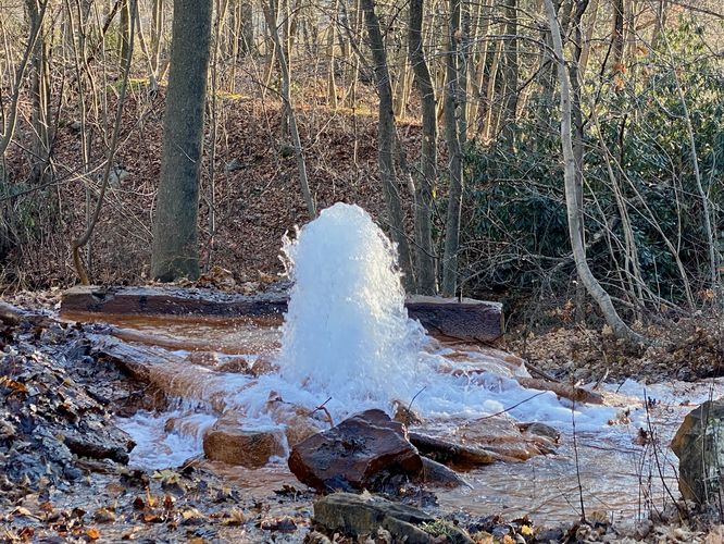
Big Run Mine Geyser in Ashland, Pennsylvania is a roadside attraction where forced water shoots out of an abandoned coal mine ventilation shaft to form a "geyser".

This is not a hike but rather a quick roadside stop in the town of Ashland along Big Mine Run Road. This "geyser" is not a real geyser, but rather a result of high pressured water being forced out of the ground through an abandoned mine ventilation shaft. The water shoots out of the abandoned coal mine to create the geyser effect -- the water itself is no taller than about 3-feet at its highest. This roadside oddity is by far one of the weirdest attractions found in Pennsylvania.

Parking
Visitors will find a parking turnout located at the coordinates provided, along the south side Big Mine Run Road. There's a parking turnout at the geyser, large enough to fit one vehicle, as of November 2023.

Private Property
Note that the surrounding area is privately-owned. Unsure if the parking turnout is privately-owned, but it's smart to not spend much time here to not bother the neighborhood. Either way, seeing the geyser is a quick stop.
Explore 10 trails near Centralia, PA
  1. Parking

    40.786551, -76.318741
  2. Main Trailhead

    40.786492, -76.318835
  3. Big Mine Run Geyser

    40.786442, -76.318864
    Big Mine Run Geyser
No community routes found. To add your own hike as a Community Route for this Trail guide, leave a Trip Report with an attached GPX file.

Hazards

Ticks - Lyme Disease More Info (CDC)

Seasons

All

Photo Albums

Trip Reports

Trail Guide By:
Admin user profile picture
0 miles / 0 km
0 miles / 0 km
November 24, 2023
Weird roadside stop. No trespassing signs line the road east of the geyser. Geyser sits on private property.
Hiking

Weather Forecast

In Centralia, PA

Explore Hiking Trails

You May Also Like

Colorado's Million Dollar Highway - Plan a day's drive adventure along the iconic Million Dollar Highway in Colorado. Explore the best short trails, roadside stops, waterfalls, vistas, ghost towns, and hot springs within a ~6 hour road trip.
Explore

Colorado's Million Dollar Highway

Plan a day's drive adventure along the iconic Million Dollar Highway in Colorado. Explore the best short trails, roadside stops, waterfalls, vistas, ghost towns, and hot springs within a ~6 hour road trip.

Read
New York's Best Waterfalls - Whether you're planning a day hike, roadside stop, or a leisurely short walk, this guide provides hikers, travelers, and locals alike with 63 different locations to over 100 scenic waterfalls to help plan your next adventure!
Explore

New York's Best Waterfalls

Whether you're planning a day hike, roadside stop, or a leisurely short walk, this guide provides hikers, travelers, and locals alike with 63 different locations to over 100 scenic waterfalls to help plan your next adventure!

Read

Before you boogie...

Find our trail guides useful? Consider becoming a Supporter to unlock perks!

MyHikes is an indie platform that makes exploring public trails easier for everyone. The platform has no investors, no ads, and is owned and operated by one person, Dave Miller. Dave has personally mapped and written over 1,800 trail guides on MyHikes for the public to explore. MyHikes has helped millions outdoor enthusiasts plan their next adventure.

But it takes a lot of time 🕦, money 💰, work, and espresso shots ☕ to run MyHikes, including hiking , mapping , writing , and publishing new trails with high-quality (accurate) information... along with software engineering (coding) the platform like building new features, website and mobile app development (iOS and Android), site maintainance . and much much more.

Supporters unlock website and mobile app perks with an annual one-time payment of $25 (you renew) 😎👍. Or you can simply make a Donation of your choice. Otherwise, you can support us by telling your friends about MyHikes - both quick and free 🎉

Admin user profile picture

Dave Miller
MyHikes Founder