Loading...

🔥 End of Summer sale! 50% off on Supporter Accounts — now through September 1st. Learn More.

Bent Mountain Falls Hike

Directions
Map
Pictures
Send to App
Distance:
4.6 Miles / 7.4 km
Type:
Loop
Difficulty:
Moderate
Time to Hike:
2 hours, ~18 minutes
Features:
Surface Type:
Dirt
Town:
Bent Mountain, Virginia
Directions:
37.133235, -80.182666
Added:
April 03, 2025
Updated:
April 06, 2025
Guide by:
Copy Trail Link Hiking this trail? Send a friend or family member a link to this trail guide for your own safety. Hike at your own risk (disclaimer)
Loading...
Loading...
379'

Total Change
1,014'

Ascent
1,008'

Descent

Download the Trail Route for Offline Use

Supporters get exclusive access to download trail routes to the MyHikes app for offline use. Stay prepared on your adventure, even without an internet connection! Become a Supporter today to unlock this feature and hike with confidence.

Send to App

Bent Mountain Falls Hike

The Bottom Creek Gorge Preserve, located south of Roanoke in the highlands of the Blue Ridge Plateau, features a spectacular gorge and arguably the tallest waterfall in Virginia. Before joining Goose Creek at the downstream end to form the South Fork Roanoke River, Bottom Creek flows through a narrow ~3-mile gorge that varies between 200 feet in depth at the upstream end to 900 feet in depth at the downstream end.

On this hike you'll pass by “The Kettles” when you enter the gorge, a series of enormous rapids in succession that beg to be explored further. The highlight of the hike is the overlook for Bent Mountain Falls, listed as the 2nd highest waterfall in Virginia at 200 feet. Camp Creek cascades and freefalls directly into Bottom Creek from the mountains above, creating a spectacular vista. It is arguably the tallest single waterfall in Virginia including the series of cascades above the lower drop, ranging between 340-370 feet high. Either way, the Bottom Creek Gorge Preserve is a relatively unheralded gem that is worth a visit.

Please note: Dogs are not allowed at any Conservancy preserve.

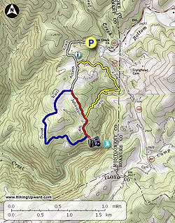
  • Mile 0.0 – Starting at the parking area pass through the horse gate beside the kiosk following the entrance road to the trail system.
  • Mile 0.6 – At a T-junction turn left on the Knight Trail (yellow blaze) leaving the entrance road.
  • Mile 0.8 – Pass by a small pond on the right. After the pond the trail soon parallels Bottom Creek as you enter the upstream end of the gorge.
  • Mile 1.6 – Take the side trail on the left which leads down to a bend in Bottom Creek. Far upstream you can see the bottom drop of a series of waterfalls known as “The Kettles.” If you have time you may want to follow the creek upstream to get a better view of these powerful rapids.
  • Mile 2.0 – The Knight Trail ends at a T-junction with the Johnston Trail (red blaze), turn left.
  • Mile 2.3 – T-junction with the Duval Trail (blue blaze) on the right. Continue straight to the waterfall overlook.
  • Mile 2.4 – The Johnston Trail ends at the overlook for Bent Mountain Falls. From this perch nearly 400 feet above Bottom Creek you have a bird’s eye view of Bent Mountain Falls. Listed at 200 feet, this waterfall is seemingly much taller. Camp Creek plunges over 360 feet directly into Bottom Creek, making this arguably the tallest waterfall in Virginia.
  • Mile 2.5 – Back at the trail junction turn left on the Duval Trail (blue blaze). Initially the Duval Trail follows the rim of the gorge before turning right to head back towards the entrance. Once you leave the gorge the trail passes through patches of pine forest and cleared fields.
  • Mile 3.9 – The Duval Trail ends at a T-junction with the Johnston Trail and entrance road, continue straight to finish the hike.
  • Mile 4.6 – Hike ends at the parking lot.
By HikingUpward Contributor: Zach Robbins
Explore 11 trails near Bent Mountain, VA
  1. Parking

    37.133235, -80.182666
  2. Main Trailhead

    37.133019, -80.182471
No community routes found. To add your own hike as a Community Route for this Trail guide, leave a Trip Report with an attached GPX file.

Hazards

Ticks - Lyme Disease More Info (CDC)
Snakes
Poison Ivy/Oak

Seasons

All

Photo Albums

+ Add Photo Album

Upload your photos from the trail to help others know what to expect.

Trip Reports (Reviews)

Rated 4.0 out of 5 based on 3 ratings.
By: Hiking Wahoo
4.6 miles / 7.4 km
May 05, 2024
We made a trip here while in Roanoke. Overall the hike is very nice. The trails are well maintained and marked. We took a different route than described however. We hike down the Johnson (red) trail to the falls overlook and hiked back out the Duvall (blue) trail. The Johnson trail has a couple of sections of switchbacks, the Duvall trail was relatively gentle hills on the way back. Small parking area, rutted road getting to the parking but passable.
Legacy Review
By: David D.
4.6 miles / 7.4 km
October 09, 2022
Gorgeous and diverse hike. There are some amazing creeks here along with a pond and the breathtaking falls at the end of the red blazed trail. Not too difficult, but there are a couple of parts that are challenging. The blue blazed trail was my favorite portion of the hike. Lots of weaving in and out of forests and meadows. There were a couple of fallen trees and one that was particularly hard to cross, but other than that this is a new favorite for me.
Legacy Review
By: The Hiking Club
4.6 miles / 7.4 km
April 09, 2021
My second time here, this time with 2 adults and 3 kids (age 5-10). There are three trails that branch off the entrance trail, marked by color. The red trail is the shortest but most difficult. The yellow trail runs closer to the creek, taking you to the water's edge in one pretty spot. The blue trail is the easiest and has some abandoned houses and graves. Make sure to check out the massive trees that are partially hollow, they were really neat.
Legacy Review

Weather Forecast

In Bent Mountain, VA

Explore Hiking Trails

You May Also Like

New York's Best Waterfalls - Whether you're planning a day hike, roadside stop, or a leisurely short walk, this guide provides hikers, travelers, and locals alike with 63 different locations to over 100 scenic waterfalls to help plan your next adventure!
Explore

New York's Best Waterfalls

Whether you're planning a day hike, roadside stop, or a leisurely short walk, this guide provides hikers, travelers, and locals alike with 63 different locations to over 100 scenic waterfalls to help plan your next adventure!

Read
25 Best Day Hikes in North Carolina - Discover the top 25 best day hikes in North Carolina, from breathtaking waterfalls to mountain peaks. Explore hidden gems, scenic views, and trails suitable for all skill levels, perfect for your next outdoor adventure.
Explore

25 Best Day Hikes in North Carolina

Discover the top 25 best day hikes in North Carolina, from breathtaking waterfalls to mountain peaks. Explore hidden gems, scenic views, and trails suitable for all skill levels, perfect for your next outdoor adventure.

Read

Before you boogie...

Find our trail guides useful? Consider becoming a Supporter to unlock perks!

MyHikes is an indie platform that makes exploring public trails easier for everyone. The platform has no investors, no ads, and is owned and operated by one person, Dave Miller. Dave has personally mapped and written over 1,800 trail guides on MyHikes for the public to explore. MyHikes has helped millions outdoor enthusiasts plan their next adventure.

But it takes a lot of time 🕦, money 💰, work, and espresso shots ☕ to run MyHikes, including hiking , mapping , writing , and publishing new trails with high-quality (accurate) information... along with software engineering (coding) the platform like building new features, website and mobile app development (iOS and Android), site maintainance . and much much more.

Supporters unlock website and mobile app perks with an annual one-time payment of $25 (you renew) 😎👍. Or you can simply make a Donation of your choice. Otherwise, you can support us by telling your friends about MyHikes - both quick and free 🎉

Admin user profile picture

Dave Miller
MyHikes Founder