Loading...

๐ŸŽ‰ Enjoy a Free 7-Day Supporter Trial and Unlock Exclusive Perks โ€” No Credit Card Required. Learn more.

Behunin Cabin

Directions
Map
Pictures
Send to App
Distance:
0.1 Miles / 0.2 km
Type:
Out-and-Back
Difficulty:
Easy
Time to Hike:
~5 minutes
Features:
Surface Type:
Dirt
Park:
Capitol Reef National Park
Town:
Fruita, Utah
Directions:
38.282455, -111.170364
Added:
September 26, 2023
Updated:
October 04, 2023
Copy Trail Link Hiking this trail? Send a friend or family member a link to this trail guide for your own safety. Hike at your own risk (disclaimer)
Loading...
Loading...
3'

Total Change
3'

Ascent
3'

Descent

Download the Trail Route for Offline Use

Supporters get exclusive access to download trail routes to the MyHikes app for offline use. Stay prepared on your adventure, even without an internet connection! Become a Supporter today to unlock this feature and hike with confidence.

Send to App

Behunin Cabin

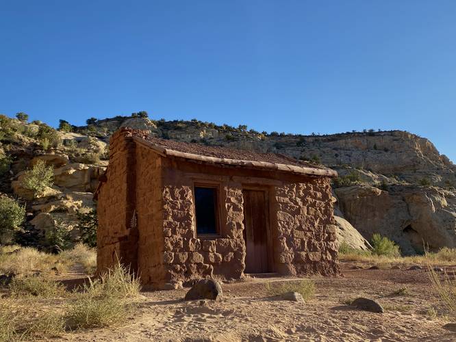
The Behunin Cabin at Capitol Reef National Park near Fruita, Utah is an easy 0.1-mile out-and-back walk that leads to the historic and long-abandoned home of some of Capitol Reef's earliest settlers.

This is not a hike but rather a very short roadside stop where visitors can walk up to and photograph the historic Behunin Cabin. This cabin, while occupied for only 1-year during the 1880s, still stands despite the test of time and is upkept by the Capitol Reef National Park staff.

History
This one-room cabin was built in 1882 by Elijah Cutler Behunin and his family. They were some of the earliest pioneers to attempt to establish homesteads in the Capitol Reef area. Within a year of building this cabin, the Behunin family moved away in search of a more suitable location after repeated flash flooding, rock slides, and other constant problems that ruined their efforts to farm the land. They eventually moved up-canyon to higher ground of Fruita, becoming one of the first families to settle in that area.

Parking
Visitors will find a large parking turnout at the coordinates provided, located on the eastern side of UT-24.

Pets
Dogs are allowed here and at other public parking lots within the park. Dogs must be leashed and cleaned up after. Please read more about Capitol Reef National Park's pet rules.
Explore 21 trails near Fruita, UT
  1. Parking

    38.282455, -111.170364
  2. Main Trailhead

    38.282352, -111.170433
  3. Behunin Cabin at Capitol Reef National Park

    38.282192, -111.170525
    Behunin Cabin at Capitol Reef National Park
No community routes found. To add your own hike as a Community Route for this Trail guide, leave a Trip Report with an attached GPX file.

Hazards

Snakes

Seasons

All

Photo Albums

Trip Reports

Trail Guide By:
Admin user profile picture
0.1 miles / 0.2 km
0.1 miles / 0.2 km
September 26, 2023
Hiking
Preview of the MyHikes mobile app interface

Track, Log, and Explore Hikes with the MyHikes App

Shop Landscape Prints
Shop our landscape prints from Capitol Reef National Park

Weather Forecast

In Fruita, UT

Explore Hiking Trails

You May Also Like

Colorado's Million Dollar Highway - Plan a day's drive adventure along the iconic Million Dollar Highway in Colorado. Explore the best short trails, roadside stops, waterfalls, vistas, ghost towns, and hot springs within a ~6 hour road trip.
Explore

Colorado's Million Dollar Highway

Plan a day's drive adventure along the iconic Million Dollar Highway in Colorado. Explore the best short trails, roadside stops, waterfalls, vistas, ghost towns, and hot springs within a ~6 hour road trip.

Read
Glacier's Going-to-the-Sun Road - Discover the breathtaking beauty of Glacier National Park along the iconic Going-to-the-Sun Road. From stunning roadside stops to picturesque waterfalls and vistas, this engineering marvel offers endless opportunities for exploration.
Explore

Glacier's Going-to-the-Sun Road

Discover the breathtaking beauty of Glacier National Park along the iconic Going-to-the-Sun Road. From stunning roadside stops to picturesque waterfalls and vistas, this engineering marvel offers endless opportunities for exploration.

Read
New York's Best Waterfalls - Whether you're planning a day hike, roadside stop, or a leisurely short walk, this guide provides hikers, travelers, and locals alike with 63 different locations to over 100 scenic waterfalls to help plan your next adventure!
Explore

New York's Best Waterfalls

Whether you're planning a day hike, roadside stop, or a leisurely short walk, this guide provides hikers, travelers, and locals alike with 63 different locations to over 100 scenic waterfalls to help plan your next adventure!

Read

Before you boogie...

Find our trail guides useful? Consider becoming a Supporter to unlock perks!

MyHikes is an indie platform that makes exploring public trails easier for everyone. The platform has no investors, no ads, and is owned and operated by one person, Dave Miller. Dave has personally mapped and written over 1,800 trail guides on MyHikes for the public to explore. MyHikes has helped millions outdoor enthusiasts plan their next adventure.

But it takes a lot of time ๐Ÿ•ฆ, money ๐Ÿ’ฐ, work, and espresso shots โ˜• to run MyHikes, including hiking , mapping , writing , and publishing new trails with high-quality (accurate) information... along with software engineering (coding) the platform like building new features, website and mobile app development (iOS and Android), site maintainance . and much much more.

Supporters unlock website and mobile app perks with an annual one-time payment of $25 (you renew) ๐Ÿ˜Ž๐Ÿ‘. Or you can simply make a Donation of your choice. Otherwise, you can support us by telling your friends about MyHikes - both quick and free ๐ŸŽ‰

Admin user profile picture

Dave Miller
MyHikes Founder