Woodland Trail
The trail is 0.6 miles one-way and you can hike back on it or hike down the Spring Hollow trail to get back; however, it'll be anywhere from 1 - 1.3 miles total.
Near the western section of the trail is a short vista trail that leads to the power-lines that run through the park. Not the best views, but it's a nice change from the trail.
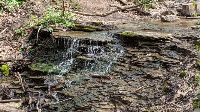
There's also a small waterfall at the intersection of the Spring Hollow trail on the north eastern portion of this trail.
No dogs or biking.
Know Before You Go
Interactive topographic map for Woodland Trail located in Fox Chapel, PA. Click the "View Map" button to load GPS coordinates and trail markers.
View map
Get directions
- Distance
- 1.3 mi
- Difficulty
- Moderate
- Type
- Out-and-Back
- Est. Time
- 39 min
- Elev. Gain
- 256'
- Rating
- 0.0
- Added
- March 27, 2017
- Updated
- June 10, 2018
Weather Forecast
Tonight
Low
67°F
Smoke
Saturday
High
85°F
Areas Of Smoke then Chance Showers And Thunderstorms
Saturday Night
Low
65°F
Showers And Thunderstorms
Sunday
High
80°F
Mostly Sunny
Sunday Night
Low
57°F
Mostly Clear
Monday
High
83°F
Sunny
Monday Night
Low
66°F
Mostly Cloudy then Chance Showers And Thunderstorms
Tuesday
High
83°F
Showers And Thunderstorms
Tuesday Night
Low
65°F
Showers And Thunderstorms
Wednesday
High
78°F
Chance Showers And Thunderstorms
Wednesday Night
Low
56°F
Chance Showers And Thunderstorms then Partly Cloudy
Thursday
High
78°F
Sunny
Thursday Night
Low
57°F
Mostly Clear
Friday
High
81°F
Mostly Sunny
Don't let Google decide who you trust.


Loading...
<strong>Trail map and elevation chart not rendering in print mode?</strong> Simply scroll to the trail map section, then try printing again!
Total Change
162 ft.
49 m
49 m
Ascent
256 ft.
78 m
78 m
Descent
256 ft.
78 m
78 m
Loading...
Features
- Waterfalls
- Water Source
Points of interest
-
Parking
40.542821, -79.905214 -
Main Trailhead
40.54471, -79.908989 -
Small Waterfall below the wood trail bridge
40.546, -79.907
Safety information
For your own safety: plan ahead, let someone know where you'll be, and hike at your own risk.
Availability
Spring
Surface type
Dirt
Trip Reports (Reviews)
Ready to help fellow hikers? Add a trip report to share your experience!
1.3
miles
/ 2.1 km
May 02, 2020
Hiking
Pictures
No community routes found. To add your own hike as a Community Route for this Trail guide, leave a Trip Report with an attached GPX file.


You may also like

Explore
Pennsylvania's Grand Canyon
Explore Pennsylvania's Grand Canyon, officially named Pine Creek Gorge, including hiking trails, vistas, overlooks, waterfalls, backcountry campsites, backpacking trails.

Explore
New York's Best Waterfalls
Whether you're planning a day hike, roadside stop, or a leisurely short walk, this guide provides hikers, travelers, and locals alike with 63 different locations to over 100 scenic waterfalls to help plan your next adventure!

Explore
25 Best Day Hikes in West Virginia
Discover 25 of the best day hikes in West Virginia, from scenic overlooks to wilderness trails—perfect for every level of hiker.

Explore
Best of the Alps: Hiking, Adventure & Scenery
Plan your ultimate European Alps adventure! Discover the best hiking trails, epic scenery, and villages in the Swiss Alps, Dolomites, Chamonix, and Lake Como.
beechwood farms nature reserve

