Loading...

🎉 Enjoy a Free 7-Day Supporter Trial and Unlock Exclusive Perks — No Credit Card Required. Learn more.

Bears Den and Sam Moore Shelter Hike

Directions
Map
Pictures
Send to App
Distance:
6.1 Miles / 9.8 km
Type:
Out-and-Back
Difficulty:
Moderate
Time to Hike:
3 hours, ~5 minutes
Features:
Appalachian Trail hike
Surface Type:
Dirt
Town:
Bluemont, Virginia
Directions:
39.110177, -77.853978
Added:
April 03, 2025
Updated:
April 06, 2025
Copy Trail Link Hiking this trail? Send a friend or family member a link to this trail guide for your own safety. Hike at your own risk (disclaimer)
Loading...
Loading...
598'

Total Change
1,967'

Ascent
1,964'

Descent

Download the Trail Route for Offline Use

Supporters get exclusive access to download trail routes to the MyHikes app for offline use. Stay prepared on your adventure, even without an internet connection! Become a Supporter today to unlock this feature and hike with confidence.

Send to App

Bears Den and Sam Moore Shelter Hike

This can be a challenging hike along the 'roller-coaster' section of the Appalachian Trail in Northern Virginia. The hike starts out with an expansive view to the west from the Bears Den Overlook then heads south on the Appalachian Trail passing over several ridges on the way to the Sam Moore Shelter in 3.3 miles. There are three campsites along the route, with the best next to Spout Run with enough space to accommodate several tents. There is also a large tent camping area at the shelter with several fire rings.

Other popular hikes in the immediate area are: Raven Rocks, Ashby Hollow, Hollow Brook, and the short Bears Den Overlook hike from the Snickers Gap/Rt. 7 commuter lot. This hike can also be completed starting from the commuter lot at Snickers Gap/Rt. 7 then heading south on the Appalachian Trail. This will add an additional 1.4 miles/230ft, making for a hike total 8.0 miles/2,010ft.

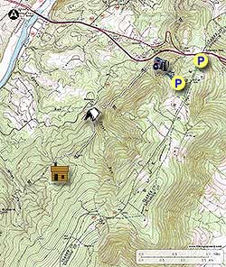
  • Mile 0.0 - From the Bears Den Trail Center parking area start up the gravel road and immediately stay left at the stone wall following the blue blazed connector trail. The trail leads to the Bears Den Overlook and intersection with the white blazed Appalachian Trail.

  • Mile 0.2 - At the intersection with the Appalachian Trail descend to the right and Bears Den Overlook. From the overlook the view westward is of the Winchester valley and the Shenandoah River. Return back to the intersection with the connector trail then descend southwards on the white blazed Appalachian Trail. The trail is rocky and steep, making several switchbacks.

  • Mile 0.9 - Pass a campsite on your right, then cross a small wooden footbridge over the first of several streams. The A.T. will pass over several small ridges then descend to Spout Run.

  • Mile 2.0 - Arrive at Spout Run where there is a large campsite area suitable for multiple tents next to the stream. Spout Run is very rarely dry, so this campsite is reliable to have a water source. Cross Spout Run and climb the longest ascent of the hike. Gain 530 vertical feet on the way to the hilltop. You'll know you're at the ridge when the trail passes through two large boulders.

  • Mile 2.8 - At the top of the hill there is another large campsite with an obstructed view to the southwest. This campsite does not have a water source. Descend through a rocky area then in 0.4 miles reach the final stream crossing on the way out. In spring and summer a large number of Green Corn Lilly's grow around the stream. Cross the stream, and arrive at the intersection with the Sam Moore Shelter connector trail.

  • Mile 3.2 - Turn left and follow the blue blazed connector trail 0.1 miles to the shelter.

  • Mile 3.3 - Arrive at the Sam Moore Shelter and camping/picnic area. At the shelter there is also a day use covered picnic table, privy 70 yards behind the shelter, and just on the other side of the shelter, next to the stream, a large tent camping area with its own fire ring. Return to Bears Den via the same route on the A.T.

  • Mile 6.1 - Arrive back at the Bears Den Trail Center parking area.

Explore 38 trails near Bluemont, VA
  1. Parking

    39.110177, -77.853978
  2. Main Trailhead

    39.110177, -77.853978
No community routes found. To add your own hike as a Community Route for this Trail guide, leave a Trip Report with an attached GPX file.

Hazards

Ticks - Lyme Disease More Info (CDC)
Snakes
Poison Ivy/Oak

Seasons

All

Blaze Color

White

Trip Reports

Trail Guide By:
HikingUpward user profile picture
6.1 miles / 9.8 km

Weather Forecast

In Bluemont, VA

Explore Hiking Trails

You May Also Like

New York's Best Waterfalls - Whether you're planning a day hike, roadside stop, or a leisurely short walk, this guide provides hikers, travelers, and locals alike with 63 different locations to over 100 scenic waterfalls to help plan your next adventure!
Explore

New York's Best Waterfalls

Whether you're planning a day hike, roadside stop, or a leisurely short walk, this guide provides hikers, travelers, and locals alike with 63 different locations to over 100 scenic waterfalls to help plan your next adventure!

Read
25 Best Day Hikes in North Carolina - Discover the top 25 best day hikes in North Carolina, from breathtaking waterfalls to mountain peaks. Explore hidden gems, scenic views, and trails suitable for all skill levels, perfect for your next outdoor adventure.
Explore

25 Best Day Hikes in North Carolina

Discover the top 25 best day hikes in North Carolina, from breathtaking waterfalls to mountain peaks. Explore hidden gems, scenic views, and trails suitable for all skill levels, perfect for your next outdoor adventure.

Read

Before you boogie...

Find our trail guides useful? Consider becoming a Supporter to unlock perks!

MyHikes is an indie platform that makes exploring public trails easier for everyone. The platform has no investors, no ads, and is owned and operated by one person, Dave Miller. Dave has personally mapped and written over 1,800 trail guides on MyHikes for the public to explore. MyHikes has helped millions outdoor enthusiasts plan their next adventure.

But it takes a lot of time 🕦, money 💰, work, and espresso shots ☕ to run MyHikes, including hiking , mapping , writing , and publishing new trails with high-quality (accurate) information... along with software engineering (coding) the platform like building new features, website and mobile app development (iOS and Android), site maintainance . and much much more.

Supporters unlock website and mobile app perks with an annual one-time payment of $25 (you renew) 😎👍. Or you can simply make a Donation of your choice. Otherwise, you can support us by telling your friends about MyHikes - both quick and free 🎉

Admin user profile picture

Dave Miller
MyHikes Founder