Bear Hole Reservoir Trail
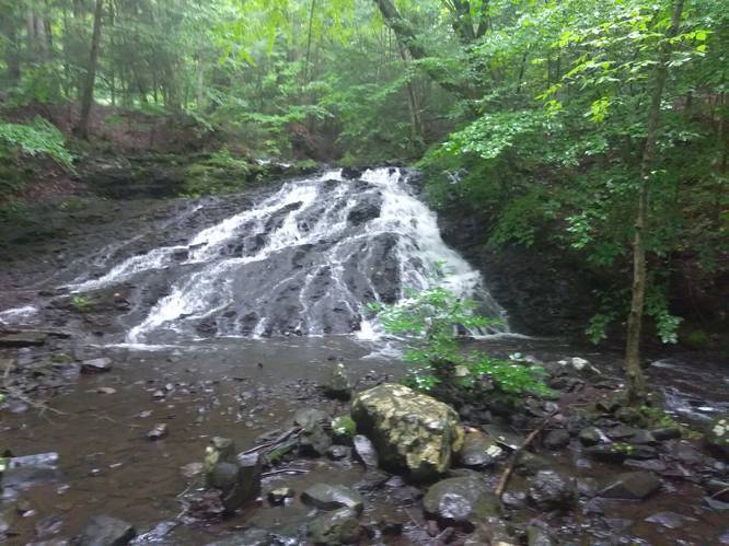
The trail is a gravel access road that is accessible to all skill levels. There are only a few views of the small reservoir along the trail, but the trade-off is a beautiful waterfall with a very large old stone chimney beside it in the northwestern section of the loop.
Biking and dogs are both allowed on this trail.
Know Before You Go
Interactive topographic map for Bear Hole Reservoir Trail located in West Springfield, MA. Click the "View Map" button to load GPS coordinates and trail markers.
View map
Get directions
- Distance
- 2.6 mi
- Difficulty
- Easy
- Type
- Loop
- Est. Time
- 1.3 hrs
- Elev. Gain
- 354'
- Rating
- 0.0
- Added
- August 23, 2018
- Updated
- January 23, 2020
Weather Forecast
Don't let Google decide who you trust.


Loading...
<strong>Trail map and elevation chart not rendering in print mode?</strong> Simply scroll to the trail map section, then try printing again!
Total Change
174 ft.
53 m
53 m
Ascent
354 ft.
108 m
108 m
Descent
308 ft.
94 m
94 m
Loading...
Features
- Dogs
- Waterfalls
- Water Source
- Biking
Points of interest
-
Parking
42.128489, -72.67556 -
Main Trailhead
42.128347, -72.675748 -
Waterfall along Paucatuck Brook
42.135197, -72.680143
Safety information
For your own safety: plan ahead, let someone know where you'll be, and hike at your own risk.
Availability
All seasons
Surface type
Universal Access
Trip Reports (Reviews)
Ready to help fellow hikers? Add a trip report to share your experience!
No community routes found. To add your own hike as a Community Route for this Trail guide, leave a Trip Report with an attached GPX file.


You may also like

Explore
Best of the Alps: Hiking, Adventure & Scenery
Plan your ultimate European Alps adventure! Discover the best hiking trails, epic scenery, and villages in the Swiss Alps, Dolomites, Chamonix, and Lake Como.

Explore
Colorado's Million Dollar Highway
Plan a day's drive adventure along the iconic Million Dollar Highway in Colorado. Explore the best short trails, roadside stops, waterfalls, vistas, ghost towns, and hot springs within a ~6 hour road trip.

Explore
Glacier's Going-to-the-Sun Road
Discover the breathtaking beauty of Glacier National Park along the iconic Going-to-the-Sun Road. From stunning roadside stops to picturesque waterfalls and vistas, this engineering marvel offers endless opportunities for exploration.

Explore
Hike Washington's National Parks & Forests
Find the best day hikes in Washington's National Parks and Forests. Explore panoramic alpine vistas, turquoise lakes, and stunning waterfalls.
a park

