The Bark Cabin Old Growth Hemlocks hike at Tiadaghton State Forest near Waterville, Pennsylvania is a moderate 2.1-mile out-and-back hike that leads to a grove of old growth eastern hemlock trees within the Bark Cabin Natural Area that age to be around 200 years old.
Trails
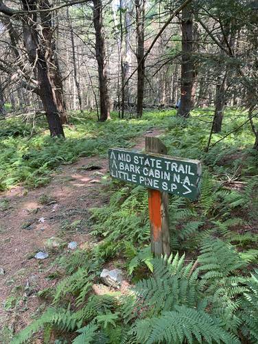
This hike follows one named trail: Mid State Trail (orange blazes).
Hike Description
This trail begins along Hackett Rd and follows the Mid State Trail north as it leads through several different types of forests on the way to the Bark Cabin Natural Area. First, hikers will pass through a pine forest where most of the forest floor is open with pine needle substrate that lasts as far as the eye can see. The trail in this portion of the hike, is by far the most comfortable for your feet, since the needles give the ground a little "bounce" to your step. Watch your step; however, as roots are hidden amongst the pine needles. Additionally, while watching your feet, you may just get poked in the eye or raked across the face with an old dead pine branch that stretch across the trail around eye-level.
Creek Crossing / Bark Cabin Natural Area - Mile 0.4
After passing through the pine forest, the trail will head downhill along an easy grade as it reverts back to mostly deciduous trees before the trail reaches a creek. On the northern side of the creek is where the Bark Cabin Natural Area begins, around mile 0.4.
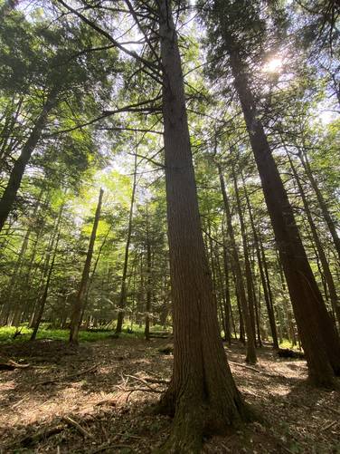
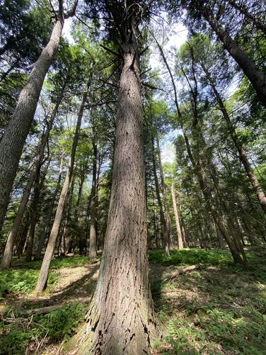
Old Growth Hemlocks - Mile 1 to 1.1
After entering the Bark Cabin Natural Area, hikers may wonder where exactly these old growth eastern hemlock trees are located. Keep hiking north along the Mid State Trail to find a set of old growth eastern hemlocks around mile 1 to 1.1. During this hike, in July 2022, I (Admin) measured three different eastern hemlocks. The largest tree measured in around 103.5 inches in circumference, which is ~83.693 cm D.b.h., and approx. 210 years old. The smallest, large, eastern hemlock I measured was ~102 inches in circumference, which is ~82.47cm D.b.h, or around a similar age of ~205-210 years old. These trees could be older if they were growing in a very dark and dense forest in the early stages of their life, however, because the dark forest would have slowed their growth rate.
Hiking Out
While this is the same but opposite hike in, the walk out is a bit more work than the walk in. This hike should be considered moderate due to the elevation gain and loss.
Warning
Bugs: This hike was very buggy during July, 2022. Bug spray is recommended.
Parking
There's a small parking turnout near the trailhead that's large enough to fit just one vehicle. The road is also a very skinny dirt road with no additional parking turnouts.
Pets
Dogs are allowed if leashed.
Trails
This hike follows one named trail: Mid State Trail (orange blazes).
Hike Description
This trail begins along Hackett Rd and follows the Mid State Trail north as it leads through several different types of forests on the way to the Bark Cabin Natural Area. First, hikers will pass through a pine forest where most of the forest floor is open with pine needle substrate that lasts as far as the eye can see. The trail in this portion of the hike, is by far the most comfortable for your feet, since the needles give the ground a little "bounce" to your step. Watch your step; however, as roots are hidden amongst the pine needles. Additionally, while watching your feet, you may just get poked in the eye or raked across the face with an old dead pine branch that stretch across the trail around eye-level.
Creek Crossing / Bark Cabin Natural Area - Mile 0.4
After passing through the pine forest, the trail will head downhill along an easy grade as it reverts back to mostly deciduous trees before the trail reaches a creek. On the northern side of the creek is where the Bark Cabin Natural Area begins, around mile 0.4.
Old Growth Hemlocks - Mile 1 to 1.1
After entering the Bark Cabin Natural Area, hikers may wonder where exactly these old growth eastern hemlock trees are located. Keep hiking north along the Mid State Trail to find a set of old growth eastern hemlocks around mile 1 to 1.1. During this hike, in July 2022, I (Admin) measured three different eastern hemlocks. The largest tree measured in around 103.5 inches in circumference, which is ~83.693 cm D.b.h., and approx. 210 years old. The smallest, large, eastern hemlock I measured was ~102 inches in circumference, which is ~82.47cm D.b.h, or around a similar age of ~205-210 years old. These trees could be older if they were growing in a very dark and dense forest in the early stages of their life, however, because the dark forest would have slowed their growth rate.
Hiking Out
While this is the same but opposite hike in, the walk out is a bit more work than the walk in. This hike should be considered moderate due to the elevation gain and loss.
Warning
Bugs: This hike was very buggy during July, 2022. Bug spray is recommended.
Parking
There's a small parking turnout near the trailhead that's large enough to fit just one vehicle. The road is also a very skinny dirt road with no additional parking turnouts.
Pets
Dogs are allowed if leashed.