The Bar Island Path Hike at Acadia National Park in Bar Harbor, Maine is an easy 1.2-mile out-and-back hike that leads to Bar Island and provides visitors with views of Bar Harbor, Cadillac Mountain, Dorr Mountain, and Champlain Mountain. Low Tide Access Only
Note that this trail is only available to explore during low tide or approximately 1.5-hours before and after low tide. To not get stranded on Bar Island, pay attention to the local tide chart based on the time of year that you're visiting. If you do get stuck, there's rescue information on the island provided by the national park's signs.
While this route only provides a very short section of hiking on Bar Island itself, the views from the island are stunning, especially during sunset. We hiked onto Bar Island and follows the trail as it wraps around the south side where we stopped not too far down the path at a landslide area with awesome views. From this tiny corner of Bar Island, we found views of Cadillac Mountain, Dorr Mountain, and Champlain Mountain towering over the quaint bay side town of Bar Harbor. Watch your step near the edge of these landslide areas, however, as there's plenty of undermined soil and loose soil overhangs. You do not want to accidentally fall down this steep and rocky hillside.
This route turns back to town from the vista point, but you can continue on further to explore the island in full. If you hike the entire loop around the island, you'll find more views of Bar Harbor and Frenchman Bay, but the entire hike back to town will be about 3-miles. During our hike here around sunset, we didn't have enough time to explore the entire island, hence the short distance out-and-back.
Low Tide Access Only
Note that this trail is only available to explore during low tide or approximately 1.5-hours before and after low tide. To not get stranded on Bar Island, pay attention to the local tide chart based on the time of year that you're visiting. If you do get stuck, there's rescue information on the island provided by the national park's signs.Hiking to Bar Island
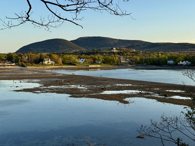
This hike begins in downtown Bar Harbor where you'll start by walking down Bridge Street to reach the Bar Island Path. This route begins near the junction of Bridge Street and West Street, just uphill from the official start of the trail. The Bar Island Path, available only at low tide, leads across a tiny section of Frenchman Bay from downtown Bar Harbor and leads to Bar Island. Along the way, visitors will find scenic views of Bar Harbor with Cadillac Mountain towering overhead. You'll find boats moored in the bay and scenic views into Frenchman Bay as well. On the far side of the trail, you'll reach Bar Island where you'll also enter Acadia National Park's boundaries. The national park presides over Bar Island and thus there's plenty of signage about the island and warnings to not get stranded during high tide.While this route only provides a very short section of hiking on Bar Island itself, the views from the island are stunning, especially during sunset. We hiked onto Bar Island and follows the trail as it wraps around the south side where we stopped not too far down the path at a landslide area with awesome views. From this tiny corner of Bar Island, we found views of Cadillac Mountain, Dorr Mountain, and Champlain Mountain towering over the quaint bay side town of Bar Harbor. Watch your step near the edge of these landslide areas, however, as there's plenty of undermined soil and loose soil overhangs. You do not want to accidentally fall down this steep and rocky hillside.
This route turns back to town from the vista point, but you can continue on further to explore the island in full. If you hike the entire loop around the island, you'll find more views of Bar Harbor and Frenchman Bay, but the entire hike back to town will be about 3-miles. During our hike here around sunset, we didn't have enough time to explore the entire island, hence the short distance out-and-back.