The Band Rock Vista Trail at the McIntyre Wild Area near Roaring Branch, Pennsylvania is an easy 1.1-mile out-and-back trail that leads to a beautiful vista point high above the Tioga River.
This trail can be hiked as a 1-mile out-and-back or shorter as a 0.1-mile out-and-back hike, depending on the clearance height of your vehicle - taller vehicles can park very close to the vista, while others may find it best suited to park about 0.55 miles down the road at a parking circle.
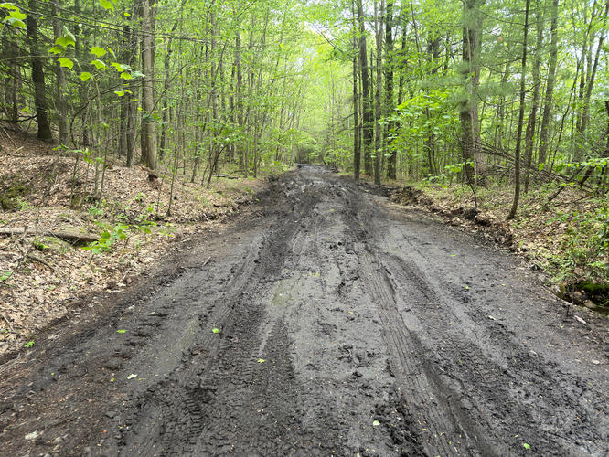
The hike out is flat and can be muddy. The McIntyre Mountain Road is generally full of potholes, some very wide and deep, so hikers will end up meandering around these.
Just before the vista is the second parking lot, yellow gate, and signage. Please follow all state forest rules when visiting. Hike down the very short path from the second parking area to the vista and enjoy the view.
Hikers will find a fire ring at the vista, but please note when you can and cannot have fires based on dates and the safety rating of the forest for that particular day (when in doubt, do not have a fire).
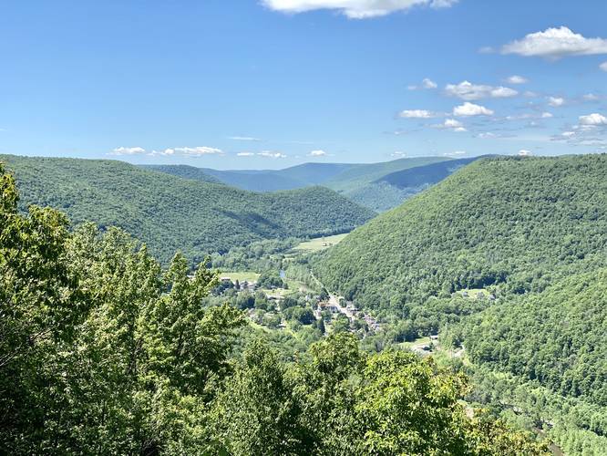
Band Rock Vista
The view from Band Rock Vista is a stunning 180-degree view of the surrounding mountains and Ralston, Pennsylvania below. Directly across the mountain range are about a dozen wind turbines, which adds a modern sight to this old rocky outcropping. The rock ledge here is about 30-feet or higher, so watch your step while exploring the area.
Parking
Hikers can find parking in two locations - at the coordinates provided, which will bring you 0.5-miles from the actual trailhead. This parking lot is preferred for vehicles that may not have very high clearance. With very high clearance vehicles you can continue driving down McIntyre Mountain Road to reach the second parking area, which is about 200-feet from the vista.
Pets
Dogs are allowed if leashed and their waste must be carried out by the hiker.
Prohibited
Camping is not allowed at the vista point or near the parking area. Fires are not allowed between March 1st and May 25th and when the district forester deems the fire hazard too high. You may call the forestry office to ask about conditions.
Road Conditions
This road is likely not maintained during the winter. Additionally, large ruts, carved out by rushing water, make this road nearly impossible for low-clearance cars to drive up to the top of the mountain ridge. Please do not attempt to drive this road if your car does not have the proper clearance.
This trail can be hiked as a 1-mile out-and-back or shorter as a 0.1-mile out-and-back hike, depending on the clearance height of your vehicle - taller vehicles can park very close to the vista, while others may find it best suited to park about 0.55 miles down the road at a parking circle.
The hike out is flat and can be muddy. The McIntyre Mountain Road is generally full of potholes, some very wide and deep, so hikers will end up meandering around these.
Just before the vista is the second parking lot, yellow gate, and signage. Please follow all state forest rules when visiting. Hike down the very short path from the second parking area to the vista and enjoy the view.
Hikers will find a fire ring at the vista, but please note when you can and cannot have fires based on dates and the safety rating of the forest for that particular day (when in doubt, do not have a fire).
Band Rock Vista
The view from Band Rock Vista is a stunning 180-degree view of the surrounding mountains and Ralston, Pennsylvania below. Directly across the mountain range are about a dozen wind turbines, which adds a modern sight to this old rocky outcropping. The rock ledge here is about 30-feet or higher, so watch your step while exploring the area.
Parking
Hikers can find parking in two locations - at the coordinates provided, which will bring you 0.5-miles from the actual trailhead. This parking lot is preferred for vehicles that may not have very high clearance. With very high clearance vehicles you can continue driving down McIntyre Mountain Road to reach the second parking area, which is about 200-feet from the vista.
Pets
Dogs are allowed if leashed and their waste must be carried out by the hiker.
Prohibited
Camping is not allowed at the vista point or near the parking area. Fires are not allowed between March 1st and May 25th and when the district forester deems the fire hazard too high. You may call the forestry office to ask about conditions.
Road Conditions
This road is likely not maintained during the winter. Additionally, large ruts, carved out by rushing water, make this road nearly impossible for low-clearance cars to drive up to the top of the mountain ridge. Please do not attempt to drive this road if your car does not have the proper clearance.