Loading...

Distance:
0.1 Miles / 0.2 km
Type:
Out-and-Back
Difficulty:
Easy
Time to Hike:
~5 minutes
Features:
Surface Type:
Universal Access
Park:
Garret Mountain Reservation
Town:
Paterson, New Jersey
Directions:
40.905701, -74.174894
Added:
December 15, 2023
Updated:
December 21, 2023
Loading...
Loading...
15 '

Total Change
15 '

Ascent
15 '

Descent

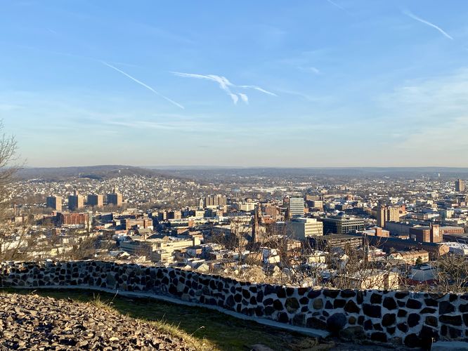
Auto Overlook (aka Paterson View) at Garret Mountain Reservation in Paterson, New Jersey is an easy universally accessible 0.1-mile out-and-back trail that features views high above Paterson.

This is not a hike but rather a very short walk that follows a paved and universally-accessible trail. Visitors don't even need to stretch their legs to take in the views of Paterson, hence the name "Auto Overlook"; however, if you're in need of a paved, universal accessible pathway and are looking for a nice view, this trail's for you.

Parking
Visitors will find a large parking lot at the coordinates provided. The lot, as of December 2023, is large enough to fit over a dozen vehicles.

Pets
Dogs are allowed only if leashed and must be cleaned up after.

Explore 8 trails near Paterson, NJ
  1. Parking

    40.905701, -74.174894
  2. Main Trailhead

    40.905801, -74.174875
  3. View of Paterson, NJ (at Auto Overlook)

    40.906211, -74.174994
    View of Paterson, NJ (at Auto Overlook)
No community routes found. To add your own hike as a Community Route for this Trail guide, leave a Trip Report with an attached GPX file.

Hazards

Ticks - Lyme Disease More Info (CDC)

Seasons

All

Photo Albums

1 Trip Report

No Star-Ratings
Write-up by:
Admin user profile picture
0.1 miles / 0.2 km
Trail added
December 15, 2023
Hiked on
December 15, 2023
Updated on
December 21, 2023

Weather Forecast

In Paterson, NJ

Explore Hiking Trails

New Hikes

Upper Rattler Run Falls
1.9 Miles
3.1 km
Hard
Out-and-Back
Battery Warren Trail
1 Mile
1.6 km
Easy
Out-and-Back
Larry's Creek Trail
3.6 Miles
5.8 km
Moderate
Out-and-Back
Mt. Morris Dam Overlook
3.3 Miles
5.3 km
Easy
Out-and-Back

Before you leave...

MyHikes is an indie web platform aimed to make exploring public trails easier for everyone. The site has no investors and is owned and operated by one person, Dave Miller (Founder & Admin). As the Founder, main contributor, and doer-of-all-things for MyHikes, I share my trips with over-detailed write-ups for fun on a volunteer basis and I believe that public trail information should be available to everyone.

It takes a lot of time ๐Ÿ•ฆ, money ๐Ÿ’ฐ, and effort (including espresso shots โ˜•) to run MyHikes, including hiking , mapping , writing , and publishing new trails with high-quality content... along with building new features, moderating, site maintainance, and app development for iOS and Android . I simply ask that if you find MyHikes' trail guides helpful to please consider becoming a Supporter to help keep the site, iOS, and Android apps available to everyone.

Supporters unlock website and in-app perks with a one-time payment of $25 (you renew) ๐Ÿ˜Ž๐Ÿ‘. Or you can simply make a Donation of your choice without a MyHikes user account. Otherwise, telling your friends about MyHikes is the next-best thing - both quick and free ๐ŸŽ‰

Thanks for visiting MyHikes and have a great hike!๏ธ

Admin user profile picture

Dave Miller
MyHikes Founder & Admin