Loading...

🔥 End of Summer sale! 50% off on Supporter Accounts — now through September 1st. Learn More.

Austin and Furnace Mountains Hike

Directions
Map
Pictures
Send to App
Distance:
12.3 Miles / 19.8 km
Type:
Loop
Difficulty:
Hard
Time to Hike:
6 hours, ~9 minutes
Features:
Appalachian Trail hike
Surface Type:
Dirt
Park:
Shenandoah National Park
Town:
Crozet, Virginia
Directions:
38.240404, -78.71069
Added:
March 18, 2025
Updated:
April 05, 2025
Guide by:
Copy Trail Link Hiking this trail? Send a friend or family member a link to this trail guide for your own safety. Hike at your own risk (disclaimer)
Loading...
Loading...
1,845'

Total Change
3,052'

Ascent
3,052'

Descent

Download the Trail Route for Offline Use

Supporters get exclusive access to download trail routes to the MyHikes app for offline use. Stay prepared on your adventure, even without an internet connection! Become a Supporter today to unlock this feature and hike with confidence.

Send to App

Austin and Furnace Mountains Hike

The Austin and Furnace Mountains loop is one of the most strenuous day hikes in the Shenandoah National Park. Not only is the hike long, at over 13 miles, but the steep descent down the Austin Mountain ridge, and long climb up the exposed Furnace Mountain trail, make the 3000+ vertical feet of gain seem even that much harder.

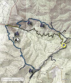
From the Browns Gap parking area pass the closed gate, and start down the yellow blazed Madison Run Fire Road (FR). In 0.8 miles look for the yellow blazed Big Run Spur Trail where the FR makes a right bend. Turn right and follow the Big Run Spur Trail uphill for 0.3 miles to the ridge, and intersection of the blue blazed Rockytop Trail.

Turn left on the Rockytop Trail for 0.4 miles to the intersection of the blue blazed Austin Mountain Trail. Stay left on the Austin Mountain Trail as it follows the ridge, then gradually begins to descend. Pass several vistas of the Furnace Mountain summit, before passing through four rock slide areas. In three miles from the Rockytop Trail, the Austin Mountain Trail will make a sharp left turn, and descend the mountain very steeply for the remaining 0.3 miles to the valley, and ending at the Madison Run FR.

Turn right on the yellow blazed Madison Run FR for 0.8 miles. 200 yards before reaching the closed gate, and SNP boundary, turn left onto the Furnace Mountain Trail. Immediately cross Madison Run, then start the ascent of Furnace Mountain. This section of the trail is very exposed, so make sure to have a good hat. In 1.8 miles arrive at a small saddle where the Furnace Mountain Summit Trail turns left. Follow the Furnace Mountain Summit Trail for 0.5 miles, passing a nice camping spot at the summit, before descending for 50 yards to the overlook.

Return the 0.5 miles to the Furnace Mountain Trail, and turn left uphill. In 2.1 miles the Furnace Mountain Trail ends at the intersection of the blue blazed Trayfoot Mountain Trail. Stay left, on the Trayfoot Mountain Trail as it descends, then climbs to the intersection of the AT/Blackrock Connector Trail in 0.6 miles. Stay left towards the Blackrock Summit, and in 0.2 miles pass through the lower section if the Blackrock area, before arriving at the intersection of the white blazed Appalachian Trail AT and Blackrock Summit.

Turn left on the white blazed AT. In 0.3 miles pass the Blackrock parking area, before crossing Skyline Drive on the AT in another 0.6 miles. After crossing Skyline Drive, pass the Jones Run parking area in 0.2 miles, and stay on the AT for the remaining 1.2 miles back to the Browns Gap parking area.
Explore 56 trails near Crozet, VA
  1. Parking

    38.240404, -78.71069
  2. Main Trailhead

    38.24054, -78.710518
No community routes found. To add your own hike as a Community Route for this Trail guide, leave a Trip Report with an attached GPX file.

Hazards

Ticks - Lyme Disease More Info (CDC)
Snakes
Poison Ivy/Oak

Seasons

All

Trip Reports (Reviews)

Rated 4.47 out of 5 based on 38 ratings.
By: GaliWalker
12.3 miles / 19.8 km
December 18, 2018
I wanted to do this as described, but Skyline Drive was closed due to 300 downed trees (courtesy of a recent ice storm). So, I hiked it from the bottom trailhead (Grottoes), at the end of Browns Gap Road. The hike was great! Don't skip the Furnace Mountain summit side trip. The view from there is second best, right after that from Blackrock, which is the highlight of the trip. Madison Run was running quite high but I was able to cross it without having to take my boots off, thanks to my knee length gaiters. It took me 6hrs to hike the loop, including about an hour to take pictures. 6hrs of bliss on a beautiful blue sky day.
Legacy Review
By: Brad & Michelle
12.3 miles / 19.8 km
August 18, 2018
We did this from the Grottoes side and went counter clock wise because we were looking for steep hill training for an upcoming marathon in Switzerland. We drove up early from Hampton roads and got on the trail by 9am.The first four miles were hard core grateful for the overcast day and occasional drizzle. Around mile 3 Brad was about 20' ahead of me on the trail when we unknowingly and unintentionally scarred a medium sized bear who fell/ran out of the tree right towards me. It's not clear which one of us was more terrified, the bear trying to get away from my husband or me trying to get away from the bear coming right towards me! We skipped the Furnace Mountain overlook based on other reviews. We checked out the Trayfoot Summit - underwhelming in August with the leaves blocking the view. Next was the Blackrock summit with stunning vistas and a breeze. From there we followed the trail to the Madison Fire Road and ran/walked that back to the start. We had 12.5 miles with over 5,400' of elevation gain in about 4 hours with a few photo stops. Great hike for a workout and some nice views. Highlight was the kindness of a fellow runner back at the parking area who offered to let us stop by his house to shower and change before our drive back to Hampton Roads! Got to love the running community!
Legacy Review
By: Hylly Rambler
12.3 miles / 19.8 km
April 08, 2018
I did this from the Grottoes side, as it's so much faster to get to from Valley locations. I also speed hiked/trail ran the loop and took the fire road all the way down instead of branching off on the Austin Mountain piece, plus I didn't do the Furnace Mountain overlook spur. This makes it an 11.9 mile loop. Outside of the bottom of the fire road, and Black Rock Summit, you don't see many people on the trail. I've done this loop about 10 times, mainly in the colder months to avoid ticks and snakes. I typically see a lot of bear, when they aren't hibernating, and occasionally deer. Yesterday all I saw was about 15 squirrel and a grouse on the fire road. For trail running it's a great loop because you get the climbing over first. It's about 4 miles of tough climbing, with 2 quarter mile downhills, to Black Rock, then 3 miles over relatively flat running on the AT, then a slightly less than 5 mile run down the fire road. I've also done the counterclockwise way and gone up Austin, which is very steep for a mile, then run the ridge cutting back to the fire road, and then taken a right and come down the fire road about 4 miles, and that makes for a 9 mile loop.
Legacy Review

Weather Forecast

In Crozet, VA

Explore Hiking Trails

You May Also Like

New York's Best Waterfalls - Whether you're planning a day hike, roadside stop, or a leisurely short walk, this guide provides hikers, travelers, and locals alike with 63 different locations to over 100 scenic waterfalls to help plan your next adventure!
Explore

New York's Best Waterfalls

Whether you're planning a day hike, roadside stop, or a leisurely short walk, this guide provides hikers, travelers, and locals alike with 63 different locations to over 100 scenic waterfalls to help plan your next adventure!

Read
25 Best Day Hikes in North Carolina - Discover the top 25 best day hikes in North Carolina, from breathtaking waterfalls to mountain peaks. Explore hidden gems, scenic views, and trails suitable for all skill levels, perfect for your next outdoor adventure.
Explore

25 Best Day Hikes in North Carolina

Discover the top 25 best day hikes in North Carolina, from breathtaking waterfalls to mountain peaks. Explore hidden gems, scenic views, and trails suitable for all skill levels, perfect for your next outdoor adventure.

Read

Before you boogie...

Find our trail guides useful? Consider becoming a Supporter to unlock perks!

MyHikes is an indie platform that makes exploring public trails easier for everyone. The platform has no investors, no ads, and is owned and operated by one person, Dave Miller. Dave has personally mapped and written over 1,800 trail guides on MyHikes for the public to explore. MyHikes has helped millions outdoor enthusiasts plan their next adventure.

But it takes a lot of time 🕦, money 💰, work, and espresso shots ☕ to run MyHikes, including hiking , mapping , writing , and publishing new trails with high-quality (accurate) information... along with software engineering (coding) the platform like building new features, website and mobile app development (iOS and Android), site maintainance . and much much more.

Supporters unlock website and mobile app perks with an annual one-time payment of $25 (you renew) 😎👍. Or you can simply make a Donation of your choice. Otherwise, you can support us by telling your friends about MyHikes - both quick and free 🎉

Admin user profile picture

Dave Miller
MyHikes Founder