The Ashley Falls Trail at Catskill Park near Haines Falls, New York is a moderate 0.6-mile out-and-back hike that leads to the top of the multi-tiered waterfall, Ashley Falls.
Hike Description
This hike begins along North Lake Road just east of Mary's Glen creek at the small parking lot. Hikers will head west along the road, crossing the road bridge, to reach the trailhead on the opposite side of the bridge. Head in along this trail to start your hike to Ashley Falls. The trail itself can be rocky and muddy with pools of still water, especially near the trail registration kiosk. Hikers will find a trail junction and signage for Ashley Falls around mile 0.2 - keep right to head toward the waterfall.
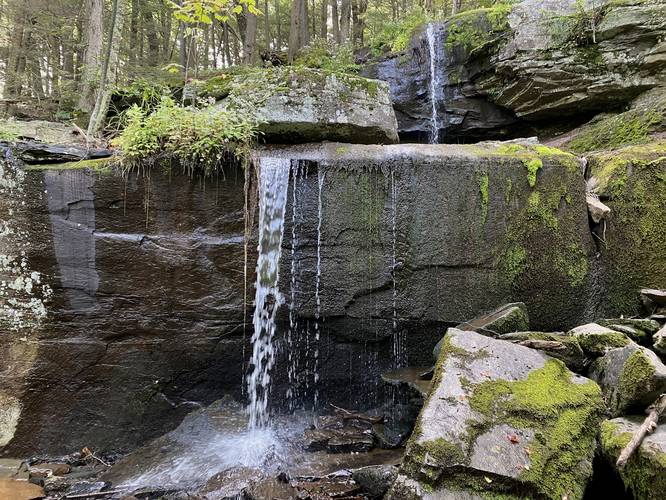
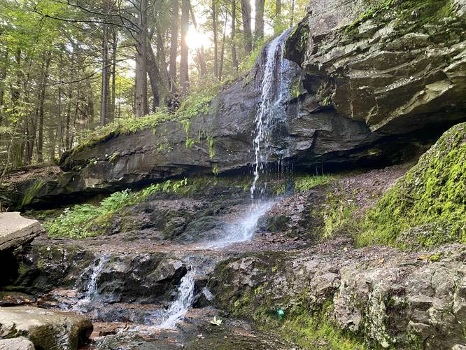
Ashley Falls - Mile 0.25
At mile 0.25, hikers will reach the base of the ~25-foot tall two-tiered waterfall, Ashley Falls. At its lowest point, the water cascades down and through a series of bedrock that hides the water during warm months. During the Spring, it's possible these rocks are overflowed with water, which would make Ashley Falls approximately ~35-feet tall with three tiers instead of ~25. Hikers have the choice, depending on the water level, to scramble up the first set of fallen bedrock to reach the first visible tier of Ashley Falls, which cascades over the bedrock at a ~7-foot tall free fall. After this, hikers can scramble up a bit more to reach the base of the upper falls portion of Ashley Falls, which cascades over and down the bedrock at about 18-feet tall. If you wish, you can even hike to the top of the waterfall; however, the best views are from below. After exploring the waterfall, hikers will have to scramble back down to then hike out along the rocky and muddy trail.
Difficulty
This hike should be considered easy unless you plan to scramble up and around Ashley Falls, hence the moderate difficulty.
Fees
As of September 2023, there's a $10 vehicle entry fee to enter this part of the park for day use and parking.
Parking
Hikers will find parking at the coordinates provided, located on the east side of Mary's Glen creek. The lot is large enough to fit about 4 or 5 vehicles maximum.
Pets
Dogs are allowed if leashed and must be cleaned up after.
Hike Description
This hike begins along North Lake Road just east of Mary's Glen creek at the small parking lot. Hikers will head west along the road, crossing the road bridge, to reach the trailhead on the opposite side of the bridge. Head in along this trail to start your hike to Ashley Falls. The trail itself can be rocky and muddy with pools of still water, especially near the trail registration kiosk. Hikers will find a trail junction and signage for Ashley Falls around mile 0.2 - keep right to head toward the waterfall.
Ashley Falls - Mile 0.25
At mile 0.25, hikers will reach the base of the ~25-foot tall two-tiered waterfall, Ashley Falls. At its lowest point, the water cascades down and through a series of bedrock that hides the water during warm months. During the Spring, it's possible these rocks are overflowed with water, which would make Ashley Falls approximately ~35-feet tall with three tiers instead of ~25. Hikers have the choice, depending on the water level, to scramble up the first set of fallen bedrock to reach the first visible tier of Ashley Falls, which cascades over the bedrock at a ~7-foot tall free fall. After this, hikers can scramble up a bit more to reach the base of the upper falls portion of Ashley Falls, which cascades over and down the bedrock at about 18-feet tall. If you wish, you can even hike to the top of the waterfall; however, the best views are from below. After exploring the waterfall, hikers will have to scramble back down to then hike out along the rocky and muddy trail.
Difficulty
This hike should be considered easy unless you plan to scramble up and around Ashley Falls, hence the moderate difficulty.
Fees
As of September 2023, there's a $10 vehicle entry fee to enter this part of the park for day use and parking.
Parking
Hikers will find parking at the coordinates provided, located on the east side of Mary's Glen creek. The lot is large enough to fit about 4 or 5 vehicles maximum.
Pets
Dogs are allowed if leashed and must be cleaned up after.