Loading...

WINTER SALE! 50% OFF Supporter Accounts — now through January 31st. Learn More.

Angels Landing Trail

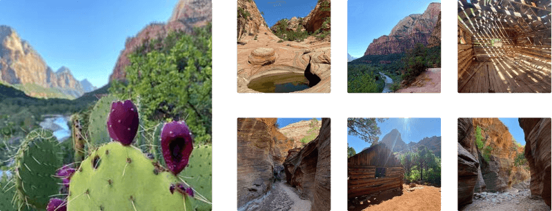
Angels Landing is one of the most breathtaking—and adrenaline-pumping—hikes in the United States. Located in Zion National Park in southwest Utah, this dramatic trail draws thousands of hikers each year to its narrow ridgeline and awe-inspiring views. With sheer drop-offs and jaw-dropping panoramas, Angels Landing is a must for thrill-seekers, but it demands preparation and caution.

Hike Overview

The Angels Landing hike is approximately 4.2 miles round trip, beginning at the Grotto Trailhead in Zion Canyon. The hike gains about 1,500 feet in elevation with some undulation along the way, and while the first half of the trail follows a paved path of switchbacks (known as Walter’s Wiggles), the final ascent is where things get intense.

From Scout Lookout onward, hikers enter the infamous chain section—a half-mile ridgeline that requires holding onto anchored chains to navigate narrow ledges flanked by steep drop-offs of up to 1,000 feet. This portion is not for the faint of heart, those with a fear of heights, or inexperienced hikers.

Parking & Shuttle Services

During winter months, hikers will find parking at the coordinates provided located in Zion Canyon near the Grotto Trailhead. Zion National Park runs a mandatory shuttle during peak seasons thus no parking is allowed at the trailhead during that time. Board at the Zion Canyon Visitor Center and get off at Stop #6 – The Grotto.

Pets

Dogs are not allowed on this hike or the trails listed along this route.

Permit & Reservation Requirements (Updated 2025)

To help manage crowding and improve safety, permits are now required to hike beyond Scout Lookout to the summit of Angels Landing. Here’s how it works:

  • Permits are issued via a seasonal lottery (3 months in advance) and a day-before lottery.

  • Apply at: https://www.recreation.gov/

  • Seasonal lottery entries open on a rolling basis:

    • Spring (March–May): Apply in January

    • Summer (June–August): Apply in April

    • Fall (September–November): Apply in July

    • Winter (December–February): Apply in October

  • The day-before lottery opens at 12:01 a.m. and closes at 3 p.m. the day prior to your intended hike. Results are released at 4 p.m.

Permits are required year-round, and each permit holder must carry a digital or printed copy while hiking.

Hazards and Safety Considerations

While the trail is undeniably beautiful, it also comes with serious risks:

  • Steep Drop-offs: The final half-mile ridge has exposed cliffs on both sides. A slip here can be fatal.

  • Crowds: Congestion on the narrow ridge can be hazardous. Start early to avoid peak times.

  • Weather: Avoid the trail during rain, snow, or strong winds. Wet rock becomes dangerously slick.

  • Heat & Dehydration: Summer temps can soar above 100°F. Bring at least 2 liters of water and use sun protection.

  • Wildlife: Do not feed or approach animals—especially those super-aggressive squirrels that may try to snatch snacks :)

Is Angels Landing Right for You?

This hike is best suited for:

  • Experienced hikers with good fitness

  • Those who are comfortable with heights and cliffs

  • Visitors who can commit to safety protocols and stay focused

If you’re unsure about the final ascent, Scout Lookout still offers fantastic views and is a great turnaround point for those not continuing to the summit.

Explore 17 trails near Washington County, UT

Know Before You Go

  • Angels Landing is a challenging 4.2-mile hike in Zion National Park known for its stunning views and dangerous, exposed ridgeline with chain sections.
  • Hiking Angels Landing requires a permit obtained through seasonal and day-before lotteries, emphasizing the need for advance planning.
  • The trail presents significant hazards, including steep drop-offs, crowds, weather conditions, and potential dehydration, making it suitable only for experienced and physically fit hikers comfortable with heights.
Interactive topographic map for Angels Landing Trail located in Washington County, UT. Click the "View Map" button to load GPS coordinates and trail markers.
Get directions
Distance
4.2 mi
Difficulty
Strenuous
Type
Out-and-Back
Est. Time
2.1 hrs
Elev. Gain
1,928'
Rating
5.0
Added
August 23, 2017
Updated
April 15, 2025

Weather Forecast

This Afternoon
High 52°F
Sunny
Tonight
Low 24°F
Partly Cloudy
Wednesday
High 52°F
Mostly Sunny
Wednesday Night
Low 22°F
Mostly Clear
Thursday
High 52°F
Sunny
Thursday Night
Low 25°F
Mostly Clear
Friday
High 56°F
Sunny
Friday Night
Low 29°F
Partly Cloudy
Saturday
High 60°F
Mostly Sunny
Saturday Night
Low 31°F
Partly Cloudy
Sunday
High 59°F
Partly Sunny
Sunday Night
Low 31°F
Mostly Cloudy
Monday
High 57°F
Mostly Sunny
Monday Night
Low 30°F
Partly Cloudy
Loading...
Total Change
1,503'
Ascent
1,928'
Descent
1,934'
Loading...

Download the GPX Data for Offline Use

Supporters get exclusive access to download trail routes to the MyHikes app for offline use. Stay prepared on your adventure, even without an internet connection! Become a Supporter today to unlock this feature and hike with confidence.

Download Angels Landing Trail GPX Data to the MyHikes Mobile App

Features

Vista / Lookout Point
Mountain Summit

Points of interest

  1. Parking

    37.25921, -112.951268
  2. Main Trailhead

    37.259261, -112.951341

Safety information

For your own safety: plan ahead, let someone know where you'll be, and hike at your own risk.

Hazards

Rockfalls, Ledges, or Scrambles

Availability

All seasons

Surface type

Dirt

Trip Reports (Reviews)

Rated 5.0 out of 5 based on 1 rating.

Ready to help fellow hikers? Add a trip report to share your experience and provide valuable insights for other hikers!

No community routes found. To add your own hike as a Community Route for this Trail guide, leave a Trip Report with an attached GPX file.

Popular categories

Scenic mountain view representing vista trails
Vista trails
Scenic gorge of cascades representing waterfall trails
Waterfall hikes
Rugged mountain terrain representing summit trails
Summit trails
Scenic mountain view representing dog-friendly trails
Dog-friendly
Scenic campsite with a view representing camping trails
Camping trails
Appalachian Trail logo representing A.T. hikes
A.T. hikes

You May Also Like

Colorado's Million Dollar Highway - Plan a day's drive adventure along the iconic Million Dollar Highway in Colorado. Explore the best short trails, roadside stops, waterfalls, vistas, ghost towns, and hot springs within a ~6 hour road trip.
Explore

Colorado's Million Dollar Highway

Plan a day's drive adventure along the iconic Million Dollar Highway in Colorado. Explore the best short trails, roadside stops, waterfalls, vistas, ghost towns, and hot springs within a ~6 hour road trip.

Read
Glacier's Going-to-the-Sun Road - Discover the breathtaking beauty of Glacier National Park along the iconic Going-to-the-Sun Road. From stunning roadside stops to picturesque waterfalls and vistas, this engineering marvel offers endless opportunities for exploration.
Explore

Glacier's Going-to-the-Sun Road

Discover the breathtaking beauty of Glacier National Park along the iconic Going-to-the-Sun Road. From stunning roadside stops to picturesque waterfalls and vistas, this engineering marvel offers endless opportunities for exploration.

Read
🍪 We use cookies to learn about site usage and to serve map tiles. You may block cookies manually in the browser. By continuing you agree. Learn more