Loading...

๐ŸŽ† 50% off 4th of July sale on Supporter Accounts โ€” now through July 6! Learn More.

Angel Windows Trail

Directions
Map
Pictures
Send to App
Distance:
0.6 Miles / 1.0 km
Type:
Out-and-Back
Difficulty:
Easy
Time to Hike:
~18 minutes
Features:
Surface Type:
Dirt
Park:
Red River Gorge Geological Area
Town:
Pine Ridge, Kentucky
Directions:
37.798957, -83.591018
Added:
May 01, 2018
Updated:
March 12, 2019
Copy Trail Link Hiking this trail? Send a friend or family member a link to this trail guide for your own safety. Hike at your own risk (disclaimer)
Loading...
Loading...
48'

Total Change
146'

Ascent
155'

Descent

Download the Trail Route for Offline Use

Supporters get exclusive access to download trail routes to the MyHikes app for offline use. Stay prepared on your adventure, even without an internet connection! Become a Supporter today to unlock this feature and hike with confidence.

Send to App

Angel Windows Trail

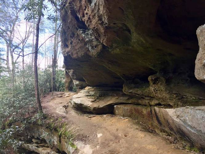
The Angel Windows Trail at Red River Gorge in Pine Ridge, Kentucky is an easy 0.6 mile out-and-back hike that leads out to a cliff formation with natural cutouts in the rock cliffs, known as Angel Windows.

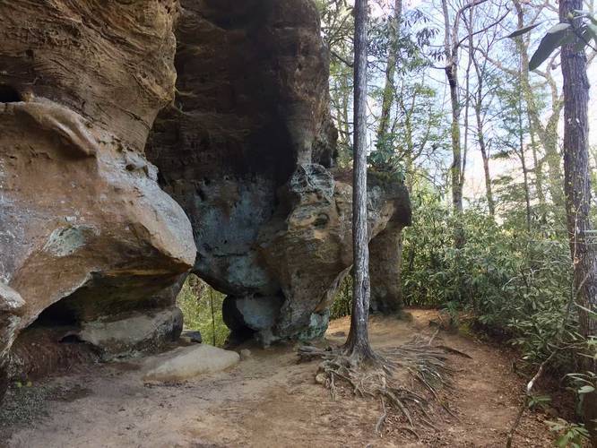
The windows are small - no more than 4 feet tall and a couple of feet wide, but they're a unique formation along the cliff. If you hike beyond the Angel Windows, you'll continue hiking along a cliff until the trail seemingly ends.

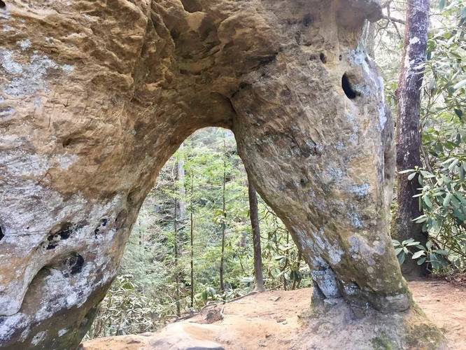
Horse head rock: At the Angel Windows is an arch that looks just like a horse's head. See the 3rd picture in this album.

Dogs are allowed on this trail.
Explore 6 trails near Pine Ridge, KY
  1. Parking

    37.798957, -83.591018
  2. Main Trailhead

    37.79867, -83.591146
  3. Angel Window / Aka Horse Head Rock

    37.799981, -83.592719
    Angel Window / Aka Horse Head Rock
  4. Angel Windows with Horse Head Rock at the end

    37.799917, -83.592597
    Angel Windows with Horse Head Rock at the end
  5. Trail follows a skinny path next to rock ledges

    37.799939, -83.592942
    Trail follows a skinny path next to rock ledges
No community routes found. To add your own hike as a Community Route for this Trail guide, leave a Trip Report with an attached GPX file.

Seasons

All

Weather Forecast

In Pine Ridge, KY

Explore Hiking Trails

You May Also Like

Colorado's Million Dollar Highway - Plan a day's drive adventure along the iconic Million Dollar Highway in Colorado. Explore the best short trails, roadside stops, waterfalls, vistas, ghost towns, and hot springs within a ~6 hour road trip.
Explore

Colorado's Million Dollar Highway

Plan a day's drive adventure along the iconic Million Dollar Highway in Colorado. Explore the best short trails, roadside stops, waterfalls, vistas, ghost towns, and hot springs within a ~6 hour road trip.

Read
Glacier's Going-to-the-Sun Road - Discover the breathtaking beauty of Glacier National Park along the iconic Going-to-the-Sun Road. From stunning roadside stops to picturesque waterfalls and vistas, this engineering marvel offers endless opportunities for exploration.
Explore

Glacier's Going-to-the-Sun Road

Discover the breathtaking beauty of Glacier National Park along the iconic Going-to-the-Sun Road. From stunning roadside stops to picturesque waterfalls and vistas, this engineering marvel offers endless opportunities for exploration.

Read
New York's Best Waterfalls - Whether you're planning a day hike, roadside stop, or a leisurely short walk, this guide provides hikers, travelers, and locals alike with 63 different locations to over 100 scenic waterfalls to help plan your next adventure!
Explore

New York's Best Waterfalls

Whether you're planning a day hike, roadside stop, or a leisurely short walk, this guide provides hikers, travelers, and locals alike with 63 different locations to over 100 scenic waterfalls to help plan your next adventure!

Read

Before you boogie...

Find our trail guides useful? Consider becoming a Supporter to unlock perks!

MyHikes is an indie platform that makes exploring public trails easier for everyone. The platform has no investors, no ads, and is owned and operated by one person, Dave Miller. Dave has personally mapped and written over 1,800 trail guides on MyHikes for the public to explore. MyHikes has helped millions outdoor enthusiasts plan their next adventure.

But it takes a lot of time ๐Ÿ•ฆ, money ๐Ÿ’ฐ, work, and espresso shots โ˜• to run MyHikes, including hiking , mapping , writing , and publishing new trails with high-quality (accurate) information... along with software engineering (coding) the platform like building new features, website and mobile app development (iOS and Android), site maintainance . and much much more.

Supporters unlock website and mobile app perks with an annual one-time payment of $25 (you renew) ๐Ÿ˜Ž๐Ÿ‘. Or you can simply make a Donation of your choice. Otherwise, you can support us by telling your friends about MyHikes - both quick and free ๐ŸŽ‰

Admin user profile picture

Dave Miller
MyHikes Founder