Loading...

🎆 50% off 4th of July sale on Supporter Accounts — now through July 6! Learn More.

Andrea Falls

Directions
Map
Pictures
Send to App
Distance:
0.1 Miles / 0.2 km
Type:
Out-and-Back
Difficulty:
Easy
Time to Hike:
~5 minutes
Features:
PA Wilds
Surface Type:
Dirt
Park:
Loyalsock State Forest
Town:
Hillsgrove, Pennsylvania
Directions:
41.42632, -76.685317
Added:
December 15, 2024
Updated:
December 16, 2024
Copy Trail Link Hiking this trail? Send a friend or family member a link to this trail guide for your own safety. Hike at your own risk (disclaimer)
Loading...
Loading...
47'

Total Change
52'

Ascent
52'

Descent

Download the Trail Route for Offline Use

Supporters get exclusive access to download trail routes to the MyHikes app for offline use. Stay prepared on your adventure, even without an internet connection! Become a Supporter today to unlock this feature and hike with confidence.

Send to App

Andrea Falls

Andrea Falls at Loyalsock State Forest near Hillsgrove, Pennsylvania is an easy 0.1-mile out-and-back off-trail hike that leads to the 20-foot tall waterfall, Andrea Falls.

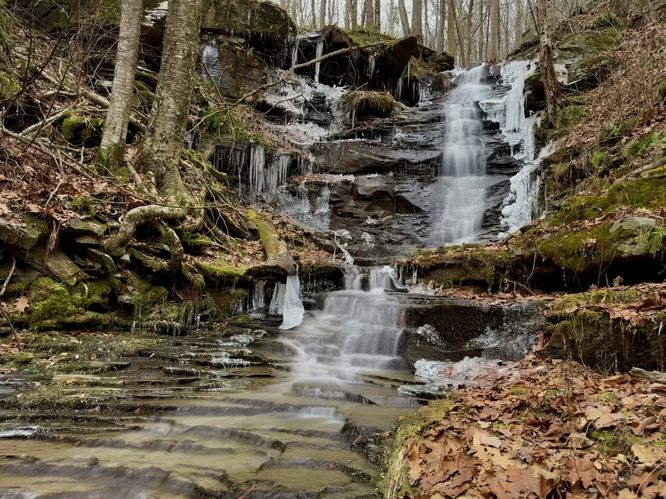
Exploring Andrea Falls

Hikers will begin their off-trail hike near the trailhead and parking coordinates provided, located along Dry Run Road. Look for the small creek that cuts down the mountainside to start the hike. Staying on the right-hand side of the creek, you'll make your way uphill, passing blowdown trees, and small saplings to reach a downstream view of the 20-foot tall Andrea Falls. If you make your way up the hill a bit further, being careful, you can traverse your way down to the creek itself to reach the base of the waterfall. At the base of Andrea Falls, you'll find a ~16-foot tall cascade that swoops down a cliff before a short 4-foot tall waterfall continues the flow along the bedrock just below. The total height of Andrea Falls is approximately 20-feet tall, but due to the swooping nature of the cascade, the waterfall is fairly quiet -- making for a scenic place to enjoy the cascading water off-trail and away from other hikers. When done exploring, the hike out is simple -- just head back to parking the way you came in.

Parking

Hikers will find a tiny parking turnout by the coordinates provided, located on the south side of Dry Run Road. The turnout is large enough to fit just a couple of vehicles as of December 2024.

Pets

Dogs are allowed if leashed and must be cleaned up after.

Warning

Steep creek banks: This off-trail hike leads up the right-hand side of the creek where you'll find some steep creek banks. Due to the tree blowdowns here, you need to get somewhat close to the creek bank to traverse over these trees, so watch your step. Remember to not fully trust steep creek banks as sometimes they've been undermined by flood waters, making them unstable.

Timber Rattlesnakes: This area is home to the Timber Rattlesnake which can be found roaming the forest between the end of April and early October each year. Be on the lookout and give any rattler you find plenty of space.
Explore 73 trails near Hillsgrove, PA
  1. Parking

    41.42632, -76.685317
  2. Main Trailhead

    41.42632, -76.685317
  3. Andrea Falls (20-feet tall)

    41.426803, -76.686006
    Andrea Falls (20-feet tall)
No community routes found. To add your own hike as a Community Route for this Trail guide, leave a Trip Report with an attached GPX file.

Hazards

Ticks - Lyme Disease More Info (CDC)
Snakes
Poison Ivy/Oak

Seasons

All

Photo Albums

Trip Reports

Trail Guide By:
Admin user profile picture
0.1 miles / 0.2 km
0.1 miles / 0.2 km
December 15, 2024
Fun little off trail adventure to the waterfall
Dogs Hiking

Weather Forecast

In Hillsgrove, PA

Explore Hiking Trails

You May Also Like

Colorado's Million Dollar Highway - Plan a day's drive adventure along the iconic Million Dollar Highway in Colorado. Explore the best short trails, roadside stops, waterfalls, vistas, ghost towns, and hot springs within a ~6 hour road trip.
Explore

Colorado's Million Dollar Highway

Plan a day's drive adventure along the iconic Million Dollar Highway in Colorado. Explore the best short trails, roadside stops, waterfalls, vistas, ghost towns, and hot springs within a ~6 hour road trip.

Read
New York's Best Waterfalls - Whether you're planning a day hike, roadside stop, or a leisurely short walk, this guide provides hikers, travelers, and locals alike with 63 different locations to over 100 scenic waterfalls to help plan your next adventure!
Explore

New York's Best Waterfalls

Whether you're planning a day hike, roadside stop, or a leisurely short walk, this guide provides hikers, travelers, and locals alike with 63 different locations to over 100 scenic waterfalls to help plan your next adventure!

Read

Before you boogie...

Find our trail guides useful? Consider becoming a Supporter to unlock perks!

MyHikes is an indie platform that makes exploring public trails easier for everyone. The platform has no investors, no ads, and is owned and operated by one person, Dave Miller. Dave has personally mapped and written over 1,800 trail guides on MyHikes for the public to explore. MyHikes has helped millions outdoor enthusiasts plan their next adventure.

But it takes a lot of time 🕦, money 💰, work, and espresso shots ☕ to run MyHikes, including hiking , mapping , writing , and publishing new trails with high-quality (accurate) information... along with software engineering (coding) the platform like building new features, website and mobile app development (iOS and Android), site maintainance . and much much more.

Supporters unlock website and mobile app perks with an annual one-time payment of $25 (you renew) 😎👍. Or you can simply make a Donation of your choice. Otherwise, you can support us by telling your friends about MyHikes - both quick and free 🎉

Admin user profile picture

Dave Miller
MyHikes Founder