Loading...

🎉 Enjoy a Free 7-Day Supporter Trial and Unlock Exclusive Perks — No Credit Card Required. Learn more.

Allegheny and Seneca Creek Hike

Directions
Map
Pictures
Send to App
Distance:
12.3 Miles / 19.8 km
Type:
Loop
Difficulty:
Hard
Time to Hike:
6 hours, ~9 minutes
Features:
Surface Type:
Dirt
Park:
Monongahela National Forest
Town:
Circleville, West Virginia
Directions:
38.711786, -79.549942
Added:
March 16, 2025
Updated:
April 05, 2025
Copy Trail Link Hiking this trail? Send a friend or family member a link to this trail guide for your own safety. Hike at your own risk (disclaimer)
Loading...
Loading...
1,161'

Total Change
1,616'

Ascent
1,617'

Descent

Download the Trail Route for Offline Use

Supporters get exclusive access to download trail routes to the MyHikes app for offline use. Stay prepared on your adventure, even without an internet connection! Become a Supporter today to unlock this feature and hike with confidence.

Send to App

Allegheny and Seneca Creek Hike

Seneca Creek and Seneca Falls make this one of the most beautiful stream hikes in the mid-atlantic. With numerous first rate camp sites along its banks, this is a definite backpackers delight. If you backpack make sure to add this fantastic hike to your list.

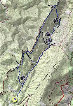
From the parking area head down the Seneca Creek Trail (TR515) 1.1 miles and turn left on the Tom Lick Trail (TR559). Ascend the mountain on what appears more of a old forestry service road than a trail before arriving at the ridge, and intersection of the Allegheny Mountain Trail.

Turn right on the Allegheny Mountain Trail (TR532) and in 0.3 miles pass the North Fork/Big Run Trail on the left, then in another 0.5 miles pass the Leading Ridge Trail again on your left. Continue on the Allegheny Mountain Trail for 0.4 miles before passing the Swallow Rock Trail and great camp site at a small pass on the ridge.

Continue uphill on the Allegheny Mountain Trail then in 1.5 miles pass the Bear Hunter Trail. 1.5 miles further the Spring Ridge Trail turns left, stay right downhill through a small clearing and rejoin the Allegheny Mountain Trail on the other side of the clearing. 0.1 miles downhill the trail will split with the Allegheny Mountain Trail turning left and the Horton Trail (TR530) turning right downhill.

Turn right on the Horton Trail as it descends the mountain steeply for 1.1 miles before arriving at Seneca Creek. Cross Seneca Creek and climb up to the Seneca Creek Trail (TR515) on the opposite bank.

Turn right on the Seneca Creek Trail passing several great camp sites just below Seneca Falls 200 yards from where you crossed the creek. Cross Seneca Creek just above the falls and pass another fantastic camp site.

In 1.5 miles from the falls there is an unmarked trail on your left. Follow it for 30 yards to one of the prettiest campsites in the forest, with an old grist stone and waterfall on the other side of the creek.

Continue up Seneca Creek Trail and pass the Bear Hunter Trail on your right in 0.1 miles, then in another 0.1 miles arrive at a clearing and the Judy Springs Campground and intersection of the Judy Springs Trail that crosses Seneca Creek on a wooden foot bridge.

Don't cross the footbridge, but remain on Seneca Creek Trail for 3.3 miles back to the parking area. Passing the Swallow Rock Trail in 1.1 miles and the Tom Lick trail in 2.4 miles.

Explore 62 trails near Circleville, WV
  1. Parking

    38.711786, -79.549942
  2. Main Trailhead

    38.711701, -79.54977
No community routes found. To add your own hike as a Community Route for this Trail guide, leave a Trip Report with an attached GPX file.

Hazards

Ticks - Lyme Disease More Info (CDC)
Snakes
Poison Ivy/Oak

Seasons

All

Trip Reports

Trail Guide By:
HikingUpward user profile picture
12.3 miles / 19.8 km

Weather Forecast

In Circleville, WV

Explore Hiking Trails

You May Also Like

Colorado's Million Dollar Highway - Plan a day's drive adventure along the iconic Million Dollar Highway in Colorado. Explore the best short trails, roadside stops, waterfalls, vistas, ghost towns, and hot springs within a ~6 hour road trip.
Explore

Colorado's Million Dollar Highway

Plan a day's drive adventure along the iconic Million Dollar Highway in Colorado. Explore the best short trails, roadside stops, waterfalls, vistas, ghost towns, and hot springs within a ~6 hour road trip.

Read
New York's Best Waterfalls - Whether you're planning a day hike, roadside stop, or a leisurely short walk, this guide provides hikers, travelers, and locals alike with 63 different locations to over 100 scenic waterfalls to help plan your next adventure!
Explore

New York's Best Waterfalls

Whether you're planning a day hike, roadside stop, or a leisurely short walk, this guide provides hikers, travelers, and locals alike with 63 different locations to over 100 scenic waterfalls to help plan your next adventure!

Read

Before you boogie...

Find our trail guides useful? Consider becoming a Supporter to unlock perks!

MyHikes is an indie platform that makes exploring public trails easier for everyone. The platform has no investors, no ads, and is owned and operated by one person, Dave Miller. Dave has personally mapped and written over 1,800 trail guides on MyHikes for the public to explore. MyHikes has helped millions outdoor enthusiasts plan their next adventure.

But it takes a lot of time 🕦, money 💰, work, and espresso shots ☕ to run MyHikes, including hiking , mapping , writing , and publishing new trails with high-quality (accurate) information... along with software engineering (coding) the platform like building new features, website and mobile app development (iOS and Android), site maintainance . and much much more.

Supporters unlock website and mobile app perks with an annual one-time payment of $25 (you renew) 😎👍. Or you can simply make a Donation of your choice. Otherwise, you can support us by telling your friends about MyHikes - both quick and free 🎉

Admin user profile picture

Dave Miller
MyHikes Founder