Loading...

๐Ÿ Fall is here! Check out our foliage map to plan your autumn hikes! Learn more.

Alger Falls

Directions
Map
Pictures
Send to App
Distance:
0.1 Miles / 0.2 km
Type:
Out-and-Back
Difficulty:
Easy
Time to Hike:
Features:
Surface Type:
Dirt
Town:
Munising, Michigan
Get Directions:
46.393207, -86.648164
Added:
September 25, 2022
Updated:
October 05, 2022
Copy Trail Link Hiking this trail? Send a friend or family member a link to this trail guide for your own safety. Hike at your own risk (disclaimer)
Loading...
Loading...
9'

Total Change
9'

Ascent
9'

Descent

Download the Trail Route for Offline Use

Supporters get exclusive access to download trail routes to the MyHikes app for offline use. Stay prepared on your adventure, even without an internet connection! Become a Supporter today to unlock this feature and hike with confidence.

Send to App

Key Takeaways

  • Alger Falls is a easily accessible 25-foot multi-tiered waterfall located in Munising, Michigan, viewable directly from M-28.
  • Parking is available in a turnout on the north side of M-28, across from M-94; be sure to fully pull off the road when viewing from your vehicle.
  • Visitors can walk along the creek to the base of the falls for a closer view, but should be prepared for muddy conditions; dogs are technically allowed but may get muddy.

Alger Falls

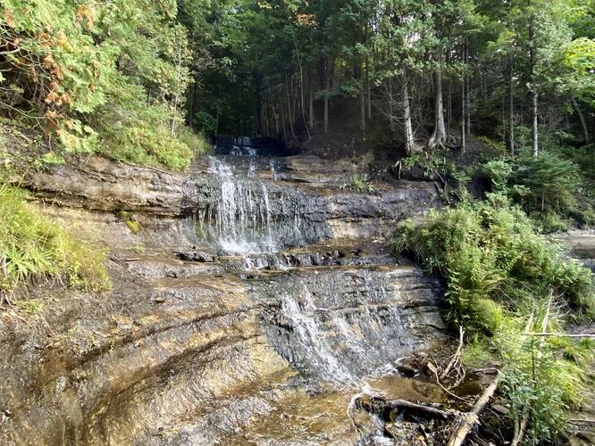
Alger Falls in Munising, Michigan is an easy walk that leads up a creek to reach the base of the 25-foot tall multi-tier waterfall, Alger Falls.

This is not a hike and more of a roadside stop as visitors can actually view the waterfall directly on M-28. Visitors can pull off M-28 and into the small turnout to view Alger Falls. If you're used to creek hiking and don't mind getting your feet or boots muddy, you can also hop over the guardrail to walk up to the base of the waterfall for a better view. Alger Fall cascades down the bedrock ledges at about 25-feet tall in total, but cascades over these ledges, making for a multi-tiered waterfall.

Parking
Visitors can find a parking turnout at the coordinates provided, located on the north side of M-28. The lot is located directly across the street from M-94. Important: if you plan to view the waterfall from your car, also plan to fully pull over from M-28. As I hiked out of this waterfall, a tourist car from Vermont came to a complete stop on M-28 with cars behind them, who laid on their horn. These people stopped to see what I was looking at as they noticed me coming up to the road from the creek... don't be like these people and simply pull over to view the waterfall.

Pets
While technically allowed, dogs should probably wait in the car unless you want your dog covered in mud.
Explore 9 trails near Munising, MI
  1. Parking

    46.393207, -86.648164
  2. Main Trailhead

    46.393193, -86.64814
  3. Alger Falls, approx. 25-feet tall

    46.393147, -86.647858
    Alger Falls, approx. 25-feet tall
No community routes found. To add your own hike as a Community Route for this Trail guide, leave a Trip Report with an attached GPX file.

Hazards

Ticks - Lyme Disease More Info (CDC)
Poison Ivy/Oak

Seasons

All

Photo Albums

+ Add Photo Album

Upload your photos from the trail to help others know what to expect.

Preview of the MyHikes mobile app interface

Track, Log, and Explore Hikes with the MyHikes App

Explore Autumn Foliage

No Change
Some Color
Low Color
Moderate Color
High Color
Peak Color
Past Peak
Sept 1 Sept 8 Sept 15 Sept 22 Sept 29 Oct 6 Oct 13 Oct 20 Oct 27 Nov 3 Nov 10 Nov 17 Nov 24

Trip Reports (Reviews)

Ready to help fellow hikers? Add a trip report to share your experience and provide valuable insights for those planning their next hike. Your review makes the trail better for everyone.

Rated 4.0 out of 5 based on 1 rating.
0.1 miles / 0.2 km
September 21, 2022
Hiking

Weather Forecast

In Munising, MI

Explore Hiking Trails

You May Also Like

Colorado's Million Dollar Highway - Plan a day's drive adventure along the iconic Million Dollar Highway in Colorado. Explore the best short trails, roadside stops, waterfalls, vistas, ghost towns, and hot springs within a ~6 hour road trip.
Explore

Colorado's Million Dollar Highway

Plan a day's drive adventure along the iconic Million Dollar Highway in Colorado. Explore the best short trails, roadside stops, waterfalls, vistas, ghost towns, and hot springs within a ~6 hour road trip.

Read
Glacier's Going-to-the-Sun Road - Discover the breathtaking beauty of Glacier National Park along the iconic Going-to-the-Sun Road. From stunning roadside stops to picturesque waterfalls and vistas, this engineering marvel offers endless opportunities for exploration.
Explore

Glacier's Going-to-the-Sun Road

Discover the breathtaking beauty of Glacier National Park along the iconic Going-to-the-Sun Road. From stunning roadside stops to picturesque waterfalls and vistas, this engineering marvel offers endless opportunities for exploration.

Read
New York's Best Waterfalls - Whether you're planning a day hike, roadside stop, or a leisurely short walk, this guide provides hikers, travelers, and locals alike with 63 different locations to over 100 scenic waterfalls to help plan your next adventure!
Explore

New York's Best Waterfalls

Whether you're planning a day hike, roadside stop, or a leisurely short walk, this guide provides hikers, travelers, and locals alike with 63 different locations to over 100 scenic waterfalls to help plan your next adventure!

Read

Before you boogie...

Find our trail guides useful? Consider becoming a Supporter to unlock perks!

MyHikes is an indie platform that makes exploring public trails easier for everyone. The platform has no investors, no ads, and is owned and operated by one person, Dave Miller. Dave has personally mapped and written over 1,800 trail guides on MyHikes for the public to explore. MyHikes has helped millions outdoor enthusiasts plan their next adventure.

But it takes a lot of time ๐Ÿ•ฆ, money ๐Ÿ’ฐ, work, and espresso shots โ˜• to run MyHikes, including hiking , mapping , writing , and publishing new trails with high-quality (accurate) information... along with software engineering (coding) the platform like building new features, website and mobile app development (iOS and Android), site maintainance . and much much more.

Supporters unlock website and mobile app perks with an annual one-time payment of $25 (you renew) ๐Ÿ˜Ž๐Ÿ‘. Or you can simply make a Donation of your choice. Otherwise, you can support us by telling your friends about MyHikes - both quick and free ๐ŸŽ‰

Admin user profile picture

Dave Miller
MyHikes Founder