The Albany Mountain Trail at the White Mountain National Forest near Bethel, Maine is a difficult 4.5-mile out-and-back trail that summits Albany Mountain and features a stunning vista point from below the summit.
Trail Description
This hike begins at the main trailhead along National Forest Road 18 and follows a beautiful, mostly-flat, conifer forest for the first 0.6-miles before the trail starts to climb the lower section of Albany Mountain.
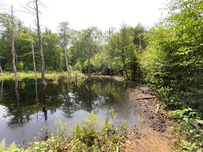
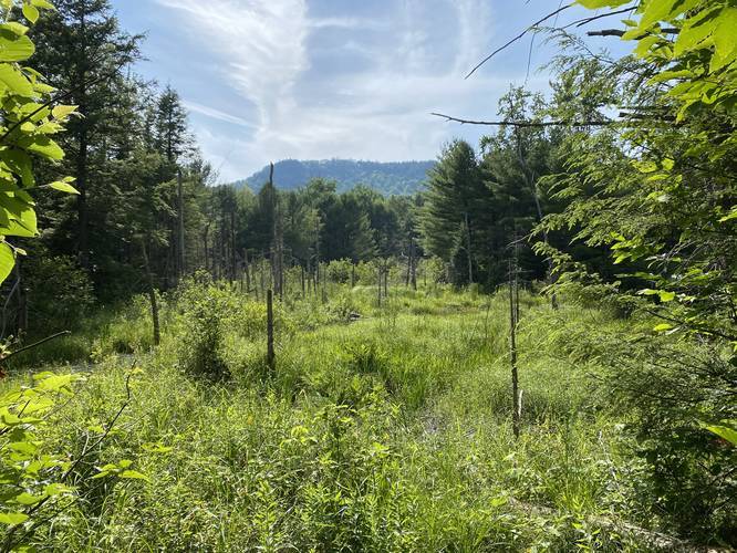
Around mile 0.5, hikers will have to cross a beaver dam. This section of the trail is the hardest in terms of balance to ensure you do not fall into the beaver pond, or sink too far into the mud along the beaver dam. Just before the beaver dam crossing, be sure to check the trail to the right-hand side for a small view point of a neighboring hill.
After the beaver dam crossing, the trail continues ascending Albany Mountain, following a ravine off to the right-hand side. The trail passes several creeks, but only one creek was flowing during mid July, 2020; however, these creeks can be used to filter water with the proper gear.
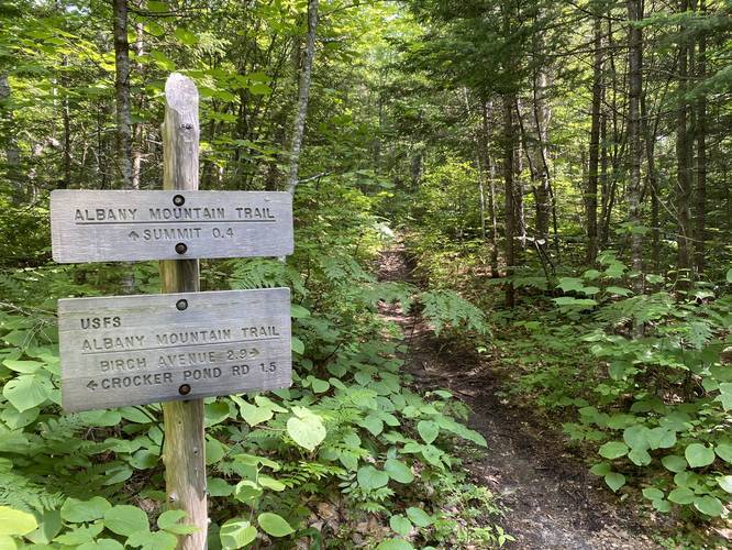
The trail will climb several rock staircases, which is not uncommon in the White Mountains; however, none of these rock staircases last very long. Eventually, the trail will reach a junction around mile 1.8 where hikers will take a left-hand turn to head toward Albany Mountain summit. Just after this trail junction, approximately 0.05-miles down the trail, is a short spur trail that leads out to the main vista point along Albany Mountain; however, this recording initially skips this spur trail to reach the summit before hiking back to this vista.
Hikers can choose to either stop at this vista to turn back or continue up toward the summit. The hike up to the summit is another annoying, but easier climb, as the trail meanders its way along granite bedrock, passing sheep laurel, blueberries, and other low-growing bushes. Finally, the trail will reach what feels like a very flat bald section of the mountain where obstructed views can be seen through the trees -- here, hikers are only 0.1-miles from the summit of Albany Mountain. Reaching the summit is as easy as following the bald granite bedrock out to a rock pile with a sign labeling the summit for Albany Mountain.
The hike back down the mountain from the summit is identical to the way up; however, hikers can choose to take in the stunning Albany Mountain vista point one last time before making their way back to parking. Remember to prepare for the beaver dam crossing again.
Reaching the Albany Mountain Vista
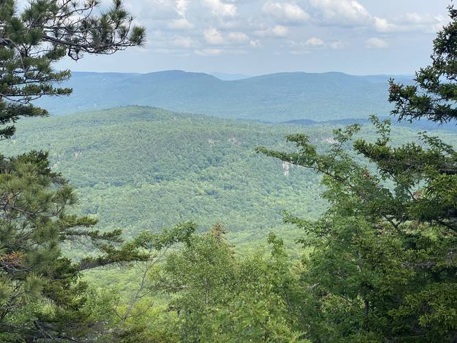
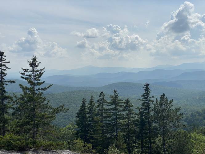
Hikers should note that the stunning vista point along Albany Mountain is NOT at the summit, but approximately 0.4-miles below the summit -- which makes this hike shorter and easier if you do not care about reaching the actual summit. Hikers will find obstructed views near the summit, but there are no views at the summit of Albany Mountain. Please see the map with points-of-interest for more info. If hikers skip Albany Mountain summit and only plan to reach the main vista, this hike is closer to 3.8-miles out-and-back total. From the Albany Mountain Vista, hikers will peer east into the White Mountain National Forest. Some keen-eyed hikers may spot Speckled Mountain in the distance.
Warning
The biggest obstacle hikers will find along this trail is a beaver dam crossing around mile 0.5. This crossing is not difficult; however, hikers must wear proper footwear in order to make it across this sketchy and very muddy beaver dam. On one side of the beaver dam is a pond where hikers can fall in and on the other side of the beaver dam is deep mud and trees. Directly in the middle are often fallen branches, logs, and tree stumps that trail maintainers have placed to help hikers across. Trekking poles are extremely helpful along this section of the trail.
Parking
Hikers can find a small parking lot at the coordinates provided. The lot is large enough to fit less than 10 cars; however, this trail is lightly trafficked.
Pets
Dogs are allowed if leashed.
Camping and Backpacking
All backpackers must follow the White Mountain National Forest primitive / dispersed / backcountry camping rules and regulations. Please note that there were no designated campsites found along this trail though.
What to Bring
Hikers should bring proper footwear and trekking poles to ensure that they can cross the beaver dam and have proper footing along the granite mountain bedrock. Hikers should bring at least 2 liters of water per person and at least 2 liters of water per small dog (more for larger dogs).
Difficulty
During the Summer, this trail is rated as "Hard"; however, during cooler months, the climb may be "Moderate" for most in-shape hikers.
Blaze Color
This trail follows yellow blazes.
Trail Description
This hike begins at the main trailhead along National Forest Road 18 and follows a beautiful, mostly-flat, conifer forest for the first 0.6-miles before the trail starts to climb the lower section of Albany Mountain.
Around mile 0.5, hikers will have to cross a beaver dam. This section of the trail is the hardest in terms of balance to ensure you do not fall into the beaver pond, or sink too far into the mud along the beaver dam. Just before the beaver dam crossing, be sure to check the trail to the right-hand side for a small view point of a neighboring hill.
After the beaver dam crossing, the trail continues ascending Albany Mountain, following a ravine off to the right-hand side. The trail passes several creeks, but only one creek was flowing during mid July, 2020; however, these creeks can be used to filter water with the proper gear.
The trail will climb several rock staircases, which is not uncommon in the White Mountains; however, none of these rock staircases last very long. Eventually, the trail will reach a junction around mile 1.8 where hikers will take a left-hand turn to head toward Albany Mountain summit. Just after this trail junction, approximately 0.05-miles down the trail, is a short spur trail that leads out to the main vista point along Albany Mountain; however, this recording initially skips this spur trail to reach the summit before hiking back to this vista.
Hikers can choose to either stop at this vista to turn back or continue up toward the summit. The hike up to the summit is another annoying, but easier climb, as the trail meanders its way along granite bedrock, passing sheep laurel, blueberries, and other low-growing bushes. Finally, the trail will reach what feels like a very flat bald section of the mountain where obstructed views can be seen through the trees -- here, hikers are only 0.1-miles from the summit of Albany Mountain. Reaching the summit is as easy as following the bald granite bedrock out to a rock pile with a sign labeling the summit for Albany Mountain.
The hike back down the mountain from the summit is identical to the way up; however, hikers can choose to take in the stunning Albany Mountain vista point one last time before making their way back to parking. Remember to prepare for the beaver dam crossing again.
Reaching the Albany Mountain Vista
Hikers should note that the stunning vista point along Albany Mountain is NOT at the summit, but approximately 0.4-miles below the summit -- which makes this hike shorter and easier if you do not care about reaching the actual summit. Hikers will find obstructed views near the summit, but there are no views at the summit of Albany Mountain. Please see the map with points-of-interest for more info. If hikers skip Albany Mountain summit and only plan to reach the main vista, this hike is closer to 3.8-miles out-and-back total. From the Albany Mountain Vista, hikers will peer east into the White Mountain National Forest. Some keen-eyed hikers may spot Speckled Mountain in the distance.
Warning
The biggest obstacle hikers will find along this trail is a beaver dam crossing around mile 0.5. This crossing is not difficult; however, hikers must wear proper footwear in order to make it across this sketchy and very muddy beaver dam. On one side of the beaver dam is a pond where hikers can fall in and on the other side of the beaver dam is deep mud and trees. Directly in the middle are often fallen branches, logs, and tree stumps that trail maintainers have placed to help hikers across. Trekking poles are extremely helpful along this section of the trail.
Parking
Hikers can find a small parking lot at the coordinates provided. The lot is large enough to fit less than 10 cars; however, this trail is lightly trafficked.
Pets
Dogs are allowed if leashed.
Camping and Backpacking
All backpackers must follow the White Mountain National Forest primitive / dispersed / backcountry camping rules and regulations. Please note that there were no designated campsites found along this trail though.
What to Bring
Hikers should bring proper footwear and trekking poles to ensure that they can cross the beaver dam and have proper footing along the granite mountain bedrock. Hikers should bring at least 2 liters of water per person and at least 2 liters of water per small dog (more for larger dogs).
Difficulty
During the Summer, this trail is rated as "Hard"; however, during cooler months, the climb may be "Moderate" for most in-shape hikers.
Blaze Color
This trail follows yellow blazes.