This easy 0.6-mile out-and-back trail within the Quehanna Wild Area near
Driftwood, Pennsylvania leads to the southern of two abandoned nuclear
jet engine test bunkers that were once used by a defense company in the
1950's.
The hike starts off along the Quehanna Highway, about 0.5 miles south of Lost Run Road and follows an old and paved, but moss-covered road out to the southern-most abandoned nuclear jet engine test bunker. On the map, this road is labeled as "Bat Cave Road".
The trail follows underneath a mixed forest for most of the way toward the abandoned test site, but the forest does open up about 0.1-miles from the bunker. Once the forest opens up to more paved road, the trail will meander around the bunker in a loop.
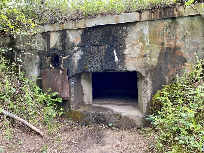
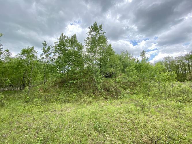
This bunker is far different from the northern abandoned bunker in that the state covered up the building with soil and rocks, probably trying to encourage bats to live inside of the building as it presented a more 'natural' look approaching the area since no building was in site. During the colder months, it'll be obvious the the small hill next to you is a bunker, but during the warmer months you may not notice it. The way the bunker used to work was the jet engine would be mounted to a concrete block outside of the bunker and while the tests were running (while the nuclear jet engine was turned on), the researchers would stay in the bunker for protection.
On this visit in late May 2020, we came around the back side of the test bunker and noticed a small trail lead up the side of it. We hiked to the top of the bunker and then hiked down a small trail that lead to the "front" side of the bunker, as facing toward the Quehanna Highway. There, the metal grate was taken off of the bunker itself with a window-sized hole exposing the interior. There was another strange wooden structure built inside of the bunker along with plenty of graffiti - it's possible that this wooden structure is used for bats. It's safe to assume this bunker is identical to the northern abandoned bunker, but the difference is just the state decided to decommission this one as more of a natural structure for bats. Within the bunker, form what we could see, were some wooden boxes attached to the bunker wall along with a wooden platform. This one wooden box is likely a bat box used to encourage bats to roost here. Stay out of the bunker to not disturbed these animals if they are in fact living in there.
After visiting the bunker, the hiker out is identical to the hike in - easy and flat. Be sure to visit the northern abandoned test bunker just up the road.
Caution
This moss-covered road can be oddly slippery.
Trail Location
This trail technically exists within several places: the M.K. Goddard/Wykoff Run Natural Area first, second the Quehanna Wild Area, and then both of which are part of Elk State Forest. The Elk State Forest side of the Quehanna Wild Area can be found on the north side of the Quehanna Highway. The southern side of the Quehanna Wild Area lies within Moshannon State Forest.
Parking
Hikers will find a small parking area in front of the service gate. Please do not block the gate.
History
In 1955, the Curtis-Wright Corporation purchased 80 square miles of state forest land from Pennsylvania to research nuclear jet engines. Their facility was named the Quehanna, based on two nearby rivers - one of which is the West Branch Susquehanna River, which is named after the Susquehannock Native Americans who once lived in the region. Curtis-Wright ended up building a few main facilities on the land. At the end of Reactor Road was a nuclear reactor along with specialized chambers for handling radioactive isotopes (aka "hot cells"). Just north of the Quehanna Highway (at the end of this trail), Curtis-Wright built bunkers for nuclear jet engine tests. Curtis-Wright left the area in 1960 when their business dried up because the United States Air Force decided to discontinue the idea behind nuclear-powered aircraft. In 1965 the Pennsylvania state legislature passed a bill that named the former lease area the Quehanna Wilderness Area. In December 1970 the Pennsylvania state forest commission changed the designation from the Quehanna Wilderness Area to Quehanna Wild Area, making it the first official Pennsylvania Wild Area. Later, the nuclear reactor would be sold off to several other companies and eventually decommissioned in 2009. The decommissioning and cleanup of the reactor and the hot cells took about eight years and cost the state of Pennsylvania over $30 million. Today, hikers can still walk down Reactor Road, but the road is blocked off to motor vehicles. The reactor site has a fence surrounding where the state had filled in the remaining area with fill. Additionally, decades ago, companies buried toxic nuclear waste in the grounds of the Quehanna Wild Area in various unrecorded locations. Over time deer and bears have dug some up the waste. More history can be found here.
The hike starts off along the Quehanna Highway, about 0.5 miles south of Lost Run Road and follows an old and paved, but moss-covered road out to the southern-most abandoned nuclear jet engine test bunker. On the map, this road is labeled as "Bat Cave Road".
The trail follows underneath a mixed forest for most of the way toward the abandoned test site, but the forest does open up about 0.1-miles from the bunker. Once the forest opens up to more paved road, the trail will meander around the bunker in a loop.
This bunker is far different from the northern abandoned bunker in that the state covered up the building with soil and rocks, probably trying to encourage bats to live inside of the building as it presented a more 'natural' look approaching the area since no building was in site. During the colder months, it'll be obvious the the small hill next to you is a bunker, but during the warmer months you may not notice it. The way the bunker used to work was the jet engine would be mounted to a concrete block outside of the bunker and while the tests were running (while the nuclear jet engine was turned on), the researchers would stay in the bunker for protection.
On this visit in late May 2020, we came around the back side of the test bunker and noticed a small trail lead up the side of it. We hiked to the top of the bunker and then hiked down a small trail that lead to the "front" side of the bunker, as facing toward the Quehanna Highway. There, the metal grate was taken off of the bunker itself with a window-sized hole exposing the interior. There was another strange wooden structure built inside of the bunker along with plenty of graffiti - it's possible that this wooden structure is used for bats. It's safe to assume this bunker is identical to the northern abandoned bunker, but the difference is just the state decided to decommission this one as more of a natural structure for bats. Within the bunker, form what we could see, were some wooden boxes attached to the bunker wall along with a wooden platform. This one wooden box is likely a bat box used to encourage bats to roost here. Stay out of the bunker to not disturbed these animals if they are in fact living in there.
After visiting the bunker, the hiker out is identical to the hike in - easy and flat. Be sure to visit the northern abandoned test bunker just up the road.
Caution
This moss-covered road can be oddly slippery.
Trail Location
This trail technically exists within several places: the M.K. Goddard/Wykoff Run Natural Area first, second the Quehanna Wild Area, and then both of which are part of Elk State Forest. The Elk State Forest side of the Quehanna Wild Area can be found on the north side of the Quehanna Highway. The southern side of the Quehanna Wild Area lies within Moshannon State Forest.
Parking
Hikers will find a small parking area in front of the service gate. Please do not block the gate.
History
In 1955, the Curtis-Wright Corporation purchased 80 square miles of state forest land from Pennsylvania to research nuclear jet engines. Their facility was named the Quehanna, based on two nearby rivers - one of which is the West Branch Susquehanna River, which is named after the Susquehannock Native Americans who once lived in the region. Curtis-Wright ended up building a few main facilities on the land. At the end of Reactor Road was a nuclear reactor along with specialized chambers for handling radioactive isotopes (aka "hot cells"). Just north of the Quehanna Highway (at the end of this trail), Curtis-Wright built bunkers for nuclear jet engine tests. Curtis-Wright left the area in 1960 when their business dried up because the United States Air Force decided to discontinue the idea behind nuclear-powered aircraft. In 1965 the Pennsylvania state legislature passed a bill that named the former lease area the Quehanna Wilderness Area. In December 1970 the Pennsylvania state forest commission changed the designation from the Quehanna Wilderness Area to Quehanna Wild Area, making it the first official Pennsylvania Wild Area. Later, the nuclear reactor would be sold off to several other companies and eventually decommissioned in 2009. The decommissioning and cleanup of the reactor and the hot cells took about eight years and cost the state of Pennsylvania over $30 million. Today, hikers can still walk down Reactor Road, but the road is blocked off to motor vehicles. The reactor site has a fence surrounding where the state had filled in the remaining area with fill. Additionally, decades ago, companies buried toxic nuclear waste in the grounds of the Quehanna Wild Area in various unrecorded locations. Over time deer and bears have dug some up the waste. More history can be found here.