This easy 1.1-mile out-and-back trail within the Quehanna Wild Area near Driftwood, Pennsylvania leads to the northern of two abandoned nuclear jet engine test bunkers that were once used by a defense company in the 1950's.
The hike starts off along the Quehanna Highway, about 0.2 miles south of Lost Run Road at the coordinates provided and follows an old and paved, but moss-covered road out to the northern-most abandoned nuclear jet engine test bunker. On the map, this road is labeled as "Bat Bunker Road".
The trail follows a conifer forest for most of the way toward the abandoned test site, but the forest does open up about 0.1-miles from the bunker. Once the forest opens up to more paved road, the trail will meander around the bunker in a loop.
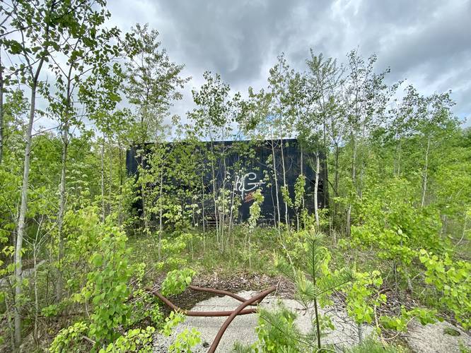
The bunker itself is really nothing special - it's a large black concrete building with a metal door and a few windows cutout with metal grates within the frames. The way the bunker used to work was the jet engine would be mounted to a concrete block outside of the bunker and while the tests were running (while the nuclear jet engine was turned on), the researchers would stay in the bunker for protection. Some sources claim this bunker is used as a bat habitat, but when visiting in late May 2020, there were no signs of bats whatsoever. The inside of the bunker is a concrete box with random graffiti. There was also a strange, newly-built wooden structure that did not make much sense of what it was - it's possible that this wooden structure is used for a bat habitat, but if so, I was totally unaware as there were no bat droppings anywhere.
After visiting the bunker the paved section essentially loops around the bunker. There really isn't much else to see and the hike back is identical to the hike in - flat and easy. Also be sure to check out the southern abandoned nuclear test bunker just down the road.
Caution
This moss-covered road can be oddly slippery.
Trail Location
This trail technically exists within several places: the M.K. Goddard/Wykoff Run Natural Area first, second the Quehanna Wild Area, and then both of which are part of Elk State Forest. The Elk State Forest side of the Quehanna Wild Area can be found on the north side of the Quehanna Highway. The southern side of the Quehanna Wild Area lies within Moshannon State Forest.
Parking
Hikers will find a small parking area in front of the service gate. Please do not block the gate.
History
In 1955, the Curtis-Wright Corporation purchased 80 square miles of state forest land from Pennsylvania to research nuclear jet engines. Their facility was named the Quehanna, based on two nearby rivers - one of which is the West Branch Susquehanna River, which is named after the Susquehannock Native Americans who once lived in the region. Curtis-Wright ended up building a few main facilities on the land. At the end of Reactor Road was a nuclear reactor along with specialized chambers for handling radioactive isotopes (aka "hot cells"). Just north of the Quehanna Highway (at the end of this trail), Curtis-Wright built bunkers for nuclear jet engine tests. Curtis-Wright left the area in 1960 when their business dried up because the United States Air Force decided to discontinue the idea behind nuclear-powered aircraft. In 1965 the Pennsylvania state legislature passed a bill that named the former lease area the Quehanna Wilderness Area. In December 1970 the Pennsylvania state forest commission changed the designation from the Quehanna Wilderness Area to Quehanna Wild Area, making it the first official Pennsylvania Wild Area. Later, the nuclear reactor would be sold off to several other companies and eventually decommissioned in 2009. The decommissioning and cleanup of the reactor and the hot cells took about eight years and cost the state of Pennsylvania over $30 million. Today, hikers can still walk down Reactor Road, but the road is blocked to motor vehicles. The reactor site has a fence surrounding where the state had filled in the remaining area. Additionally, decades ago, companies buried toxic nuclear waste in the grounds of the Quehanna Wild Area in various unrecorded locations. Over time deer and bears have dug some up the waste. More history can be found here.
The hike starts off along the Quehanna Highway, about 0.2 miles south of Lost Run Road at the coordinates provided and follows an old and paved, but moss-covered road out to the northern-most abandoned nuclear jet engine test bunker. On the map, this road is labeled as "Bat Bunker Road".
The trail follows a conifer forest for most of the way toward the abandoned test site, but the forest does open up about 0.1-miles from the bunker. Once the forest opens up to more paved road, the trail will meander around the bunker in a loop.
The bunker itself is really nothing special - it's a large black concrete building with a metal door and a few windows cutout with metal grates within the frames. The way the bunker used to work was the jet engine would be mounted to a concrete block outside of the bunker and while the tests were running (while the nuclear jet engine was turned on), the researchers would stay in the bunker for protection. Some sources claim this bunker is used as a bat habitat, but when visiting in late May 2020, there were no signs of bats whatsoever. The inside of the bunker is a concrete box with random graffiti. There was also a strange, newly-built wooden structure that did not make much sense of what it was - it's possible that this wooden structure is used for a bat habitat, but if so, I was totally unaware as there were no bat droppings anywhere.
After visiting the bunker the paved section essentially loops around the bunker. There really isn't much else to see and the hike back is identical to the hike in - flat and easy. Also be sure to check out the southern abandoned nuclear test bunker just down the road.
Caution
This moss-covered road can be oddly slippery.
Trail Location
This trail technically exists within several places: the M.K. Goddard/Wykoff Run Natural Area first, second the Quehanna Wild Area, and then both of which are part of Elk State Forest. The Elk State Forest side of the Quehanna Wild Area can be found on the north side of the Quehanna Highway. The southern side of the Quehanna Wild Area lies within Moshannon State Forest.
Parking
Hikers will find a small parking area in front of the service gate. Please do not block the gate.
History
In 1955, the Curtis-Wright Corporation purchased 80 square miles of state forest land from Pennsylvania to research nuclear jet engines. Their facility was named the Quehanna, based on two nearby rivers - one of which is the West Branch Susquehanna River, which is named after the Susquehannock Native Americans who once lived in the region. Curtis-Wright ended up building a few main facilities on the land. At the end of Reactor Road was a nuclear reactor along with specialized chambers for handling radioactive isotopes (aka "hot cells"). Just north of the Quehanna Highway (at the end of this trail), Curtis-Wright built bunkers for nuclear jet engine tests. Curtis-Wright left the area in 1960 when their business dried up because the United States Air Force decided to discontinue the idea behind nuclear-powered aircraft. In 1965 the Pennsylvania state legislature passed a bill that named the former lease area the Quehanna Wilderness Area. In December 1970 the Pennsylvania state forest commission changed the designation from the Quehanna Wilderness Area to Quehanna Wild Area, making it the first official Pennsylvania Wild Area. Later, the nuclear reactor would be sold off to several other companies and eventually decommissioned in 2009. The decommissioning and cleanup of the reactor and the hot cells took about eight years and cost the state of Pennsylvania over $30 million. Today, hikers can still walk down Reactor Road, but the road is blocked to motor vehicles. The reactor site has a fence surrounding where the state had filled in the remaining area. Additionally, decades ago, companies buried toxic nuclear waste in the grounds of the Quehanna Wild Area in various unrecorded locations. Over time deer and bears have dug some up the waste. More history can be found here.