Loading...

๐ŸŽ‰ Enjoy a Free 7-Day Supporter Trial and Unlock Exclusive Perks โ€” No Credit Card Required. Learn more.

Abandoned Mineral Creek Mine

Directions
Map
Pictures
Send to App
Distance:
0.1 Miles / 0.2 km
Type:
Out-and-Back
Difficulty:
Easy
Time to Hike:
~5 minutes
Features:
Surface Type:
Dirt
Park:
San Juan National Forest
Town:
Silverton, Colorado
Directions:
37.875467, -107.726847
Added:
June 03, 2024
Updated:
August 01, 2024
Copy Trail Link Hiking this trail? Send a friend or family member a link to this trail guide for your own safety. Hike at your own risk (disclaimer)
Loading...
Loading...
5'

Total Change
5'

Ascent
5'

Descent

Download the Trail Route for Offline Use

Supporters get exclusive access to download trail routes to the MyHikes app for offline use. Stay prepared on your adventure, even without an internet connection! Become a Supporter today to unlock this feature and hike with confidence.

Send to App

Abandoned Mineral Creek Mine

The Abandoned Mineral Creek Mine at San Juan National Forest near Silverton, Colorado is an easy 0.1-mile out-and-back off-trail walk that leads to the site of the abandoned mine, located along the Million Dollar Highway.

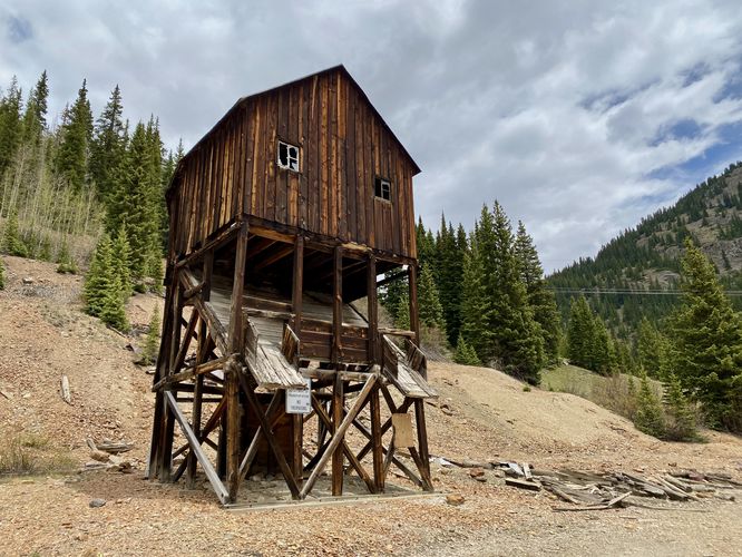
This is not a hike but rather a short walk that leads to an abandoned mine and mine shaft within the national forest. This old mining building is just one of a few historical mining structures left that depicts why the Million Dollar Highway was built and exists today. In the late 1880's prospectors moved into the area to mine the surrounding mountains for silver, gold, and eventually heavier metals like iron, zinc, and copper for WWI and WWII efforts. While this mining building can certainly be appreciated from the road, you can also get a close-up look at what miners had to enter every day to get paid. The building is strictly off limits from the public entering, so please do not enter the building. Do not disturb this historical structure but rather appreciate it from afar.

Parking
Visitors will find a parking turnout located on the south side of the Million Dollar Highway, at the coordinates provided. The turnout is large enough to fit a half-dozen vehicles as of June 2024.

Pets
Dogs are allowed if leashed.

Warning
Abandoned mine shaft: This walk leads to an abandoned mining structure that appears to have an old mine shaft located underneath. The building may have been used to haul resources out of the ground; however, it's extremely dangerous and should not be entered or climbed, per federal law. For your own safety, appreciate the building from afar.
Explore 19 trails near Silverton, CO
  1. Parking

    37.875467, -107.726847
  2. Main Trailhead

    37.875509, -107.726763
  3. Abandoned Mineral Creek Mine shaft (stay out)

    37.875961, -107.726578
    Abandoned Mineral Creek Mine shaft (stay out)
  4. View toward Lookout Peak

    37.875492, -107.726853
    View toward Lookout Peak
No community routes found. To add your own hike as a Community Route for this Trail guide, leave a Trip Report with an attached GPX file.

Seasons

All

Photo Albums

Trip Reports

Trail Guide By:
Admin user profile picture
0.1 miles / 0.2 km
0.1 miles / 0.2 km
June 03, 2024
Hiking

Weather Forecast

In Silverton, CO

Explore Hiking Trails

You May Also Like

Colorado's Million Dollar Highway - Plan a day's drive adventure along the iconic Million Dollar Highway in Colorado. Explore the best short trails, roadside stops, waterfalls, vistas, ghost towns, and hot springs within a ~6 hour road trip.
Explore

Colorado's Million Dollar Highway

Plan a day's drive adventure along the iconic Million Dollar Highway in Colorado. Explore the best short trails, roadside stops, waterfalls, vistas, ghost towns, and hot springs within a ~6 hour road trip.

Read
Glacier's Going-to-the-Sun Road - Discover the breathtaking beauty of Glacier National Park along the iconic Going-to-the-Sun Road. From stunning roadside stops to picturesque waterfalls and vistas, this engineering marvel offers endless opportunities for exploration.
Explore

Glacier's Going-to-the-Sun Road

Discover the breathtaking beauty of Glacier National Park along the iconic Going-to-the-Sun Road. From stunning roadside stops to picturesque waterfalls and vistas, this engineering marvel offers endless opportunities for exploration.

Read
New York's Best Waterfalls - Whether you're planning a day hike, roadside stop, or a leisurely short walk, this guide provides hikers, travelers, and locals alike with 63 different locations to over 100 scenic waterfalls to help plan your next adventure!
Explore

New York's Best Waterfalls

Whether you're planning a day hike, roadside stop, or a leisurely short walk, this guide provides hikers, travelers, and locals alike with 63 different locations to over 100 scenic waterfalls to help plan your next adventure!

Read

Before you boogie...

Find our trail guides useful? Consider becoming a Supporter to unlock perks!

MyHikes is an indie platform that makes exploring public trails easier for everyone. The platform has no investors, no ads, and is owned and operated by one person, Dave Miller. Dave has personally mapped and written over 1,800 trail guides on MyHikes for the public to explore. MyHikes has helped millions outdoor enthusiasts plan their next adventure.

But it takes a lot of time ๐Ÿ•ฆ, money ๐Ÿ’ฐ, work, and espresso shots โ˜• to run MyHikes, including hiking , mapping , writing , and publishing new trails with high-quality (accurate) information... along with software engineering (coding) the platform like building new features, website and mobile app development (iOS and Android), site maintainance . and much much more.

Supporters unlock website and mobile app perks with an annual one-time payment of $25 (you renew) ๐Ÿ˜Ž๐Ÿ‘. Or you can simply make a Donation of your choice. Otherwise, you can support us by telling your friends about MyHikes - both quick and free ๐ŸŽ‰

Admin user profile picture

Dave Miller
MyHikes Founder