Wyllie's Beach & Anini Beach West is a 1.1-mile out-and-back trail that leads to Wyllie's Beach, located on the western side of Anini Stream, and to the western side of Anini Beach - located on the eastern side of Anini Stream and features shallow water swimming opportunities along with sunbathing at both locations.
Hike Description
This hike begins just outside of the Westin Princeville Resort at a small parking lot. The trail begins by following a gradual path downhill, passing alongside a parking lot for the Westin Resort, and another property (which is under development as of July 2022). Around mile 0.1, the trail begins a moderate to steep descent as it follows a wide forest path with steep slopes to its eastern side. The steep section lasts for only 0.2-miles, but can be slippery and muddy, so proper footwear is recommended.
Wyllie's Beach - Mile 0.3
At mile 0.3, hikers will reach Wyllie's Beach which is a small beach located to the west of the Anini Stream. The western side of Wyllie's Beach is rocky, but the eastern side is sandy, where you can get into shallow water to cool off or hang out on its shallow sandbar.
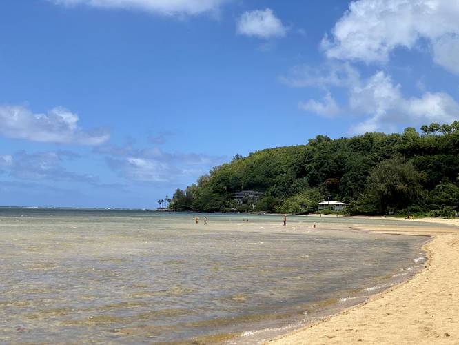
Anini Beach (West) - Mile 0.37
Walking east, just 0.07 miles from Wyllie's Beach, lies Anini Beach. Hikers will simply cross Anini Stream to reach the western side of Anini Beach. This section of the beach is special because it has a very shallow sandbar that runs out for 100-feet or so - which can be found at Wyllie's Beach as well. During certain hours, the tide allows for beach-goers to sit in the water in the sandbar. Just on the other side of this sandbar is where we stopped our hike to setup a sunbathing spot for the day, around mile 0.55. Note that on Mapbox map tiles (as of July 2022), this is labeled area as "Wyllie's Beach"; however, it's actually the western side of Anini Beach.
Parking
The parking lot is large enough to fit about 6 vehicles. Since this trail is not very popular - and because visitors can simply drive to the entrance on Anini Rd - this location is generally not busy - as of July, 2022.
Pets
Dogs are allowed on this trail, but not at the beaches. It's probably best to keep your dog at home for this one unless simply taking a walk. Always pick up after your pet.
Respecting the Land
Hawaiian land is considered sacred to native Hawaiians and many locals, so please stay on-trail, take nothing but photos, and leave nothing but footprints. Respect the locals - don't stay for long and have a backup hike planned in case the parking lot is full.
Hike Description
This hike begins just outside of the Westin Princeville Resort at a small parking lot. The trail begins by following a gradual path downhill, passing alongside a parking lot for the Westin Resort, and another property (which is under development as of July 2022). Around mile 0.1, the trail begins a moderate to steep descent as it follows a wide forest path with steep slopes to its eastern side. The steep section lasts for only 0.2-miles, but can be slippery and muddy, so proper footwear is recommended.
Wyllie's Beach - Mile 0.3
At mile 0.3, hikers will reach Wyllie's Beach which is a small beach located to the west of the Anini Stream. The western side of Wyllie's Beach is rocky, but the eastern side is sandy, where you can get into shallow water to cool off or hang out on its shallow sandbar.
Anini Beach (West) - Mile 0.37
Walking east, just 0.07 miles from Wyllie's Beach, lies Anini Beach. Hikers will simply cross Anini Stream to reach the western side of Anini Beach. This section of the beach is special because it has a very shallow sandbar that runs out for 100-feet or so - which can be found at Wyllie's Beach as well. During certain hours, the tide allows for beach-goers to sit in the water in the sandbar. Just on the other side of this sandbar is where we stopped our hike to setup a sunbathing spot for the day, around mile 0.55. Note that on Mapbox map tiles (as of July 2022), this is labeled area as "Wyllie's Beach"; however, it's actually the western side of Anini Beach.
Parking
The parking lot is large enough to fit about 6 vehicles. Since this trail is not very popular - and because visitors can simply drive to the entrance on Anini Rd - this location is generally not busy - as of July, 2022.
Pets
Dogs are allowed on this trail, but not at the beaches. It's probably best to keep your dog at home for this one unless simply taking a walk. Always pick up after your pet.
Respecting the Land
Hawaiian land is considered sacred to native Hawaiians and many locals, so please stay on-trail, take nothing but photos, and leave nothing but footprints. Respect the locals - don't stay for long and have a backup hike planned in case the parking lot is full.