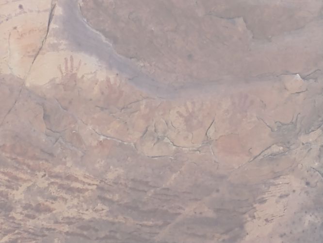
The Willow Spring Loop Trail at Red Rock Canyon National Conservation Area near Mount Charleston, Nevada is an easy 1.5-mile loop hike that features ancient pictographs, desert views, and sandstone enclaves.
Trail names: Willow Spring Loop Trail, Lost Creek Trail
Location: Red Rocks National Park, Rocky Gap Road, Las Vegas Nevada
Permitted uses: Hiking, Nature Study
Prohibited uses: Speed limit on the Scenic Loop drive is 35 mph. Parking is allowed in designated parking areas only. Do not disturb wildlife. Do not feed wild horses or burros.
Hours: Dawn to Dusk. Exit times are posted at each trailhead for each season.
Fees and Parking: There is a daily fee charged for each car, motorcycle, bicycle or pedestrian. Reservations for timed entry are required between 8:00am and 5:00pm. Reservations can be made by visiting recreation.gov. A $2.00 fee was charged to process a reservation. This fee will be in addition to the park entry fee. A one-day pass for Cars/trucks is $20.00/per vehicle with up to 4 adults including the driver. Motorcycles $10.00 per vehicle, Bicyclist $8.00 per bicycle, Pedestrian $5.00/per person. Annual passes are available, and Lifetime “America the Beautiful” passes are honored. Payment is accepted in either cash or credit card. Children under 15 years of age are admitted free of charge. There is ample parking at each trailhead.
Pets: Dogs on a leash are allowed. Please leave no trace, which means do not leave bagged dog waste along the trail.
Accessibility: There is a very small section of the trail cement paved, that is wheelchair accessible. The paved area on the eastern side of the trail allows for those in wheelchairs or with limited mobility to visit the two important archaeological sites found here. The majority of trail is not wheelchair accessible.
Hiker amenities: Restrooms, picnic tables and trash bins available near the trailhead parking area. A Trail map of the hike is posted at the trailhead.
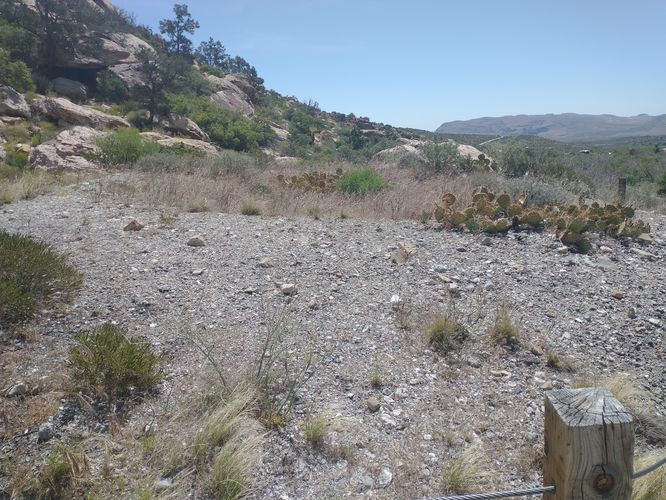
Length and Trail information: This hike is rated as an easy hike and is approximately 2 miles long. There are no blazes, but there are sporadic trail markers along the trail and thanks to the many hikers who frequent this area, the path is pretty obvious. The trail runs on either side of the Rocky Gap Road. We chose to start our hike on the Northwest side of the trail, just beyond the trailhead map post where the substrate of the trail is not wheelchair accessible. The trail is narrow, and the footing is gravely. On either side of the trail, we could see many different types of beautiful desert flora in bloom. We were able to identify several desert plants including Apache Plume, Desert Trumpet, Hairy pepperweed, Big Sagebrush, Winding Mariposa Lily, Utah Agave, Feltleaf Everlasting, Coffeeberry, Grapevines, and Palmer’s Penstemon.
The trail winds its way toward the sandstone mountains across a wash and through some rocky outcroppings. Thanks to the presence of water, there are some larger shrubs and trees growing near the trail that offer a bit of shade as well as a very attractive bird habitat. We were thrilled by all the birds we were able to identify along the hike including House finch, White-throated Swift, Yellow-breasted Chat, Spotted Towhee, Hermit Thrush, Black-chinned Sparrow, Blue-gray Gnatcatcher, Verdin, Scott’s Oriole, American Crow, and Woodhouse’s Scrub-jay.
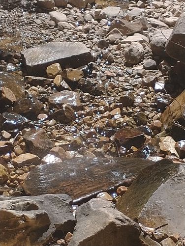
The Lost Creek Trail is a short .5-mile trail that we accessed from the Willow Spring Trail. We had hiked the Lost Creek trail on a previous trip to Las Vegas and we were curious to see if the Creek was running. The terrain on Lost Creek Trail has a bit more rock scramble than the Willow Spring Loop trail, but nothing too terribly difficult or steep. It was well worth the visit, as we did find a “waterfall”, albeit just a bit more than a trickle. The water was icy cold and just enough to cool our heads. It was a great place to stop and rest, have a snack and just enjoy the beautiful canyon walls surrounding us.
After our rest, we backtracked to the Willow Spring Loop trail and headed toward the Parking area where we crossed the road to connect to the East side of the Willow Spring Trail. On some maps, this part of the trail is also called White Rock Loop Trail. There is a stark contrast between the two sides of the trail. The Eastern side is more arid, and it’s very noticeable in the flora that is sparser and there seems to be fewer blooming plants as well. The trail is narrow and compact with lots of rocky outcroppings on the sloping sides of the canyon. The trail has a wire rope and post barrier installed in order to keep hikers on the trail and prevent them from accidentally disturbing two very special archaeological sites. The first site is an ancient Agave Roasting pit, and the second are ancient Pictographs left by Native Peoples. These two areas can be observed from a safe distance from the trail. There are placards installed at each location that give information about the sites and why they are being protected.