The Wildcat and Beehive Trails at Lyman Run State Park in Galeton, Pennsylvania can be followed for a moderate 2.3-mile loop hike. Mostly easy, some sections are considered moderate due to the moderately steep grades and the rough terrain. These trails were built by the workers from the CCC Lyman Run Camp S-88 which was also used to house POWs during WW2.
This hike starts at the turnout along Rock Run Road and follows the signs for the Wildcat Trail and Beehive Trail. Once you hit the trailhead, you'll be hiking uphill for 200 feet on the Wildcat Connector Spur until you reach the Wildcat Trail, which heads in both north and south directions. Bear to the right onto the Wildcat Trail to go in a counter-clockwise direction by continuing uphill (410 feet ascent) to the north for about 0.6 miles until you reach the intersection with the Beehive Trail on top of the ridge. At the intersection with the Beehive Trail turn left and head southwest for about 0.8-miles downhill (416 feet descent) until you reach the Snowmobile/ATV Trail near the Daggett Run Campground at the Lyman Lake State Park. At the Snowmobile/ATV Trail turn left and head east for about 0.4-miles to connect with the lower end of the Wildcat Trail for the 0.5 mile hike (177 feet climb in the first 0.2 miles) back to the parking area.
Wildcat Trail: A nice trail through a mixed northern hardwood forest. There are some small creek crossings necessary. The trail has stepping stones to help the hiker cross over the creeks and marshy areas. Water resistant hiking boots are recommend. There are plenty of massive boulders along the Wildcat Trail.
Beehive Trail: Another nice forest trail. There is a nice 3-foot cascade (41.73151, -77.75724) on this section of the Beehive Trail. The scenery of rocks and rushing water along the Beehive Trail are pleasant.
Snowmobile/ATV Trail: This trail follows the contour around the hillside above Lyman Lake. It is fairly level and easy to follow. There are seasonal obstructed views from this trail of the Lyman Lake during the late fall, winter and early spring. To get a better view of Lyman Lake, the hiker can descend about 200 feet down the hillside from the Snowmobile/ATV Trail to the Lyman Run State Park Office (41.72503, -77.75995), where a better view of Lyman Lake can be seen. The Lyman Run State Park was named for Major Issac Lyman, a American Revolutionary War Soldier and an early settler of Potter County.
Parking: Parking can be found at the coordinates provided and sits on the hairpin curve on the lower end of Rock Run Road. The trails can be access from here and there are signs to follow for the Wildcat Trail from the parking area. There's enough space for about 3 or 4 cars.
Pets: Dogs are allowed on leash and their waste must be carried out.
Hunting: Hunting is allowed here - wear orange to make yourself visible.
Waterfalls: Nice 3-foot cascade on the Beehive.
Boulders: The boulder field on the upper end of Wildcat is best in the area.
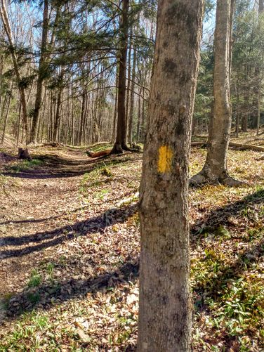
Blaze colors: Well marked with yellow blazes, which seem to have been painted over old blue blazes.
Note about Hike Data: Loss use of handheld smartphone during this hike. As a result, the GPS navigational data was not fully captured and not many pictures were taken on this hike.
This hike starts at the turnout along Rock Run Road and follows the signs for the Wildcat Trail and Beehive Trail. Once you hit the trailhead, you'll be hiking uphill for 200 feet on the Wildcat Connector Spur until you reach the Wildcat Trail, which heads in both north and south directions. Bear to the right onto the Wildcat Trail to go in a counter-clockwise direction by continuing uphill (410 feet ascent) to the north for about 0.6 miles until you reach the intersection with the Beehive Trail on top of the ridge. At the intersection with the Beehive Trail turn left and head southwest for about 0.8-miles downhill (416 feet descent) until you reach the Snowmobile/ATV Trail near the Daggett Run Campground at the Lyman Lake State Park. At the Snowmobile/ATV Trail turn left and head east for about 0.4-miles to connect with the lower end of the Wildcat Trail for the 0.5 mile hike (177 feet climb in the first 0.2 miles) back to the parking area.
Wildcat Trail: A nice trail through a mixed northern hardwood forest. There are some small creek crossings necessary. The trail has stepping stones to help the hiker cross over the creeks and marshy areas. Water resistant hiking boots are recommend. There are plenty of massive boulders along the Wildcat Trail.
Beehive Trail: Another nice forest trail. There is a nice 3-foot cascade (41.73151, -77.75724) on this section of the Beehive Trail. The scenery of rocks and rushing water along the Beehive Trail are pleasant.
Snowmobile/ATV Trail: This trail follows the contour around the hillside above Lyman Lake. It is fairly level and easy to follow. There are seasonal obstructed views from this trail of the Lyman Lake during the late fall, winter and early spring. To get a better view of Lyman Lake, the hiker can descend about 200 feet down the hillside from the Snowmobile/ATV Trail to the Lyman Run State Park Office (41.72503, -77.75995), where a better view of Lyman Lake can be seen. The Lyman Run State Park was named for Major Issac Lyman, a American Revolutionary War Soldier and an early settler of Potter County.
Parking: Parking can be found at the coordinates provided and sits on the hairpin curve on the lower end of Rock Run Road. The trails can be access from here and there are signs to follow for the Wildcat Trail from the parking area. There's enough space for about 3 or 4 cars.
Pets: Dogs are allowed on leash and their waste must be carried out.
Hunting: Hunting is allowed here - wear orange to make yourself visible.
Waterfalls: Nice 3-foot cascade on the Beehive.
Boulders: The boulder field on the upper end of Wildcat is best in the area.
Blaze colors: Well marked with yellow blazes, which seem to have been painted over old blue blazes.
Note about Hike Data: Loss use of handheld smartphone during this hike. As a result, the GPS navigational data was not fully captured and not many pictures were taken on this hike.