Loading...

WINTER SALE! 50% OFF Supporter Accounts — now through January 31st. Learn More.

White Domes Trail

The White Domes Trail at Valley of Fire State Park in Clark County, Nevada is an easy 1.8-mile out-and-back hike that leads to a stunning slot canyon, the White Domes rock formation, and desert views.

Trail names: White Domes Trail

Location: Valley of Fire State Park, 29450 Fire Cove Road, Overton Nevada

Permitted uses: Picnicking, Hiking, Photography and Nature Study

Prohibited uses: No Camping, No Bicycles, No Horseback riding, no motor vehicles. Use of drones or remote-controlled aircraft is prohibited. Collection of artifacts, fossils, rocks, plants or animals is strictly prohibited.

Hours: Sunrise to Sunset. White Domes is closed from May to September due to high heat concerns. Check the Valley of Fire website to get the exact closure date, as this will change from year to year.

Fees and Parking: There is an entry fee of $15.00 per vehicle for non-Nevada residents to enter the Valley of Fire. “America the Beautiful” passes are not honored here. Bicycle entrants are charged a $2.00 fee. Parking is allowed only in designated areas. The parking at White Domes is limited.

Pets: Dogs on a leash are allowed. Leashes must not exceed 6 feet in length. Please leave no trace, which means do not leave bagged dog waste along the trail.

Accessibility: White Domes Trail is not wheelchair accessible.

Hiker amenities: Restrooms, picnic tables and trash bins are located at the trailhead parking area.

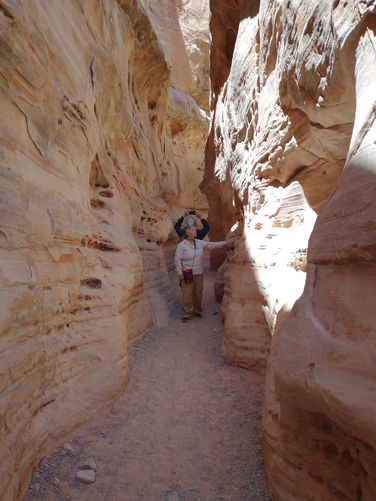
Length and Trail information: This trail is often hiked as a loop, however anyone attempting this hike as a loop must be physically able to descend a very rocky steep decline. The trail is often very crowded and hikers may be left in compromising situations while they wait for fellow hikers to pick their way down the steep descent. We were hiking with people that had limited mobility and hiking skill, so we chose to hike this as an “out and back” hike, and we chose to hike it in reverse, or backwards, of what most hikers do, thus we were able to avoid altogether the dangerous decline that our fellow hikers were incapable of doing. Doing our hike this way also was less crowded and we were able to take our time and enjoy the magnificent scenery. The hike done this way is considered an easy hike that was a total of 1.9 miles. There are no markers or blazes along the trail, but the path is well worn and is obvious, so markers or blazes would be redundant here. Hikers can download a map by visiting the park's website if needed. There are information placards located near the restrooms at the trailhead parking area. Our hike started downhill and parallel to the roadway in a very soft sand-like substrate made by eroded sandstone. Once away from the road area, hikers will enjoy the beauty of the desert and the muted layers of color in the sandstone and limestone formations surrounding the trail. The trail brings hikers to an awesome slot canyon where the passage is narrow and the walls on either side of the trail are steep. Another fun feature for movie buffs, is the remnants of an old movie set located along the trail. There is an information placard located at the site of the movie set. Make sure to go early in the day to avoid heat and crowds. Wear appropriate clothing for sun protection and bring plenty of water to stay hydrated.

Know Before You Go

  • The White Domes Trail in Valley of Fire State Park offers stunning desert scenery, a slot canyon, and movie set remnants in an easy 1.9-mile hike.
  • The trail is closed May-September due to heat, has a $15 entry fee (no "America the Beautiful" pass), and prohibits camping, bicycles, horseback riding, motor vehicles, drones, and collecting natural items.
  • Consider hiking the trail as an "out and back" rather than the loop, and in reverse order, especially with those with limited mobility, to avoid a steep, rocky descent and crowded conditions; dogs are allowed on leash.
Interactive topographic map for White Domes Trail located in Clark County, NV. Click the "View Map" button to load GPS coordinates and trail markers.
Get directions
Distance
1.9 mi
Difficulty
Easy
Type
Out-and-Back
Est. Time
54 min
Elev. Gain
262'
Rating
0.0
Added
May 25, 2024
Updated
July 22, 2024

Weather Forecast

Loading...
Total Change
159'
Ascent
262'
Descent
262'
Loading...

Download the GPX Data for Offline Use

Supporters get exclusive access to download trail routes to the MyHikes app for offline use. Stay prepared on your adventure, even without an internet connection! Become a Supporter today to unlock this feature and hike with confidence.

Download White Domes Trail GPX Data to the MyHikes Mobile App

Features

Dogs

Points of interest

  1. Parking

    36.48601, -114.532775
  2. Main Trailhead

    36.48582, -114.532884

Safety information

For your own safety: plan ahead, let someone know where you'll be, and hike at your own risk.

Hazards

Snakes (Rattlesnakes, Copperheads, others)
Rockfalls, Ledges, or Scrambles

Availability

All seasons

Surface type

Dirt

Trip Reports (Reviews)

Your opinion matters! Be the first to rate this trail.

Ready to help fellow hikers? Add a trip report to share your experience and provide valuable insights for other hikers!

No community routes found. To add your own hike as a Community Route for this Trail guide, leave a Trip Report with an attached GPX file.

Popular categories

Scenic mountain view representing vista trails
Vista trails
Scenic gorge of cascades representing waterfall trails
Waterfall hikes
Rugged mountain terrain representing summit trails
Summit trails
Scenic mountain view representing dog-friendly trails
Dog-friendly
Scenic campsite with a view representing camping trails
Camping trails
Appalachian Trail logo representing A.T. hikes
A.T. hikes

You May Also Like

Colorado's Million Dollar Highway - Plan a day's drive adventure along the iconic Million Dollar Highway in Colorado. Explore the best short trails, roadside stops, waterfalls, vistas, ghost towns, and hot springs within a ~6 hour road trip.
Explore

Colorado's Million Dollar Highway

Plan a day's drive adventure along the iconic Million Dollar Highway in Colorado. Explore the best short trails, roadside stops, waterfalls, vistas, ghost towns, and hot springs within a ~6 hour road trip.

Read
Glacier's Going-to-the-Sun Road - Discover the breathtaking beauty of Glacier National Park along the iconic Going-to-the-Sun Road. From stunning roadside stops to picturesque waterfalls and vistas, this engineering marvel offers endless opportunities for exploration.
Explore

Glacier's Going-to-the-Sun Road

Discover the breathtaking beauty of Glacier National Park along the iconic Going-to-the-Sun Road. From stunning roadside stops to picturesque waterfalls and vistas, this engineering marvel offers endless opportunities for exploration.

Read
🍪 We use cookies to learn about site usage and to serve map tiles. You may block cookies manually in the browser. By continuing you agree. Learn more