The White Bird Petroglyphs Trail at Canyon Pintado National Historical District
south of Rangely, Colorado is a moderate 0.1-mile out-and-back hike that
leads to ancient Fremont petroglyphs including some that depict corn and a white bird.
Hike
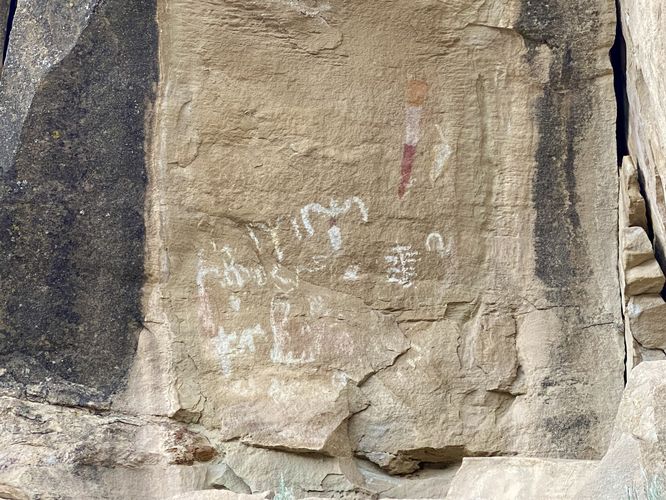
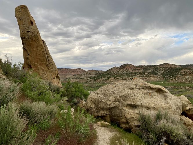
This very short hike begins along the west side of CO-139 at the coordinates provided and leads-in along a steep trail that ascends the Canyon Pintado's western slopes. The trail first passes through a cow gate -- make sure to close it on your way in and on your way out -- then it ascends the hill at a fairly steep grade before hitting a couple of switchbacks that lead up to the petroglyph site. The trail ends with the White Bird Petroglyphs and pictographs on the canyon wall in front of you. There's an interpretive sign located at the end of the trail that informs visitors on the importance of corn to the ancient native Fremont people, as this is just one of many places within the canyon where pictographs of corn can be found. Due to excavations, hundreds of corn cobs have been found within the Douglas Canyon dating back to 1100 to 900 BP (before present). After exploring the pictographs and petroglyphs, the steep trail leads back to parking for a moderate 0.1-mile hike. Remember to close the cow gate when you leave.
Parking
Hikers will find a turnout at the coordinates provided, located on the west side of CO-139. The lot is large enough to fit about 5 vehicles.
Pets
Dogs are allowed only if leashed and must be cleaned up after.
Warning
Ancient petroglyphs: This trail leads beyond the recorded route provided to ancient petroglyphs and pictographs that were created hundreds of years ago. Please do not touch or attempt to disturb in any way. Only take photos and appreciate the ancient artwork from behind the barriers.
Sun exposure: This trail has very little shade and no water sources. Pack-in all water and wear sun screen and a hat to protect against sun exposure. It's smart to hike either in the early morning or late afternoon to avoid the intense sun.
No water: This trail has no water sources so you must pack-in all water. A general rule of thumb in the desert is 1 gallon of water per person per day.
Rattlesnakes: This trail leads through rattlesnake territory, so be on the lookout and give any rattlers you find plenty of space.
Hike
This very short hike begins along the west side of CO-139 at the coordinates provided and leads-in along a steep trail that ascends the Canyon Pintado's western slopes. The trail first passes through a cow gate -- make sure to close it on your way in and on your way out -- then it ascends the hill at a fairly steep grade before hitting a couple of switchbacks that lead up to the petroglyph site. The trail ends with the White Bird Petroglyphs and pictographs on the canyon wall in front of you. There's an interpretive sign located at the end of the trail that informs visitors on the importance of corn to the ancient native Fremont people, as this is just one of many places within the canyon where pictographs of corn can be found. Due to excavations, hundreds of corn cobs have been found within the Douglas Canyon dating back to 1100 to 900 BP (before present). After exploring the pictographs and petroglyphs, the steep trail leads back to parking for a moderate 0.1-mile hike. Remember to close the cow gate when you leave.
Parking
Hikers will find a turnout at the coordinates provided, located on the west side of CO-139. The lot is large enough to fit about 5 vehicles.
Pets
Dogs are allowed only if leashed and must be cleaned up after.
Warning
Ancient petroglyphs: This trail leads beyond the recorded route provided to ancient petroglyphs and pictographs that were created hundreds of years ago. Please do not touch or attempt to disturb in any way. Only take photos and appreciate the ancient artwork from behind the barriers.
Sun exposure: This trail has very little shade and no water sources. Pack-in all water and wear sun screen and a hat to protect against sun exposure. It's smart to hike either in the early morning or late afternoon to avoid the intense sun.
No water: This trail has no water sources so you must pack-in all water. A general rule of thumb in the desert is 1 gallon of water per person per day.
Rattlesnakes: This trail leads through rattlesnake territory, so be on the lookout and give any rattlers you find plenty of space.