Loading...

WINTER SALE! 50% OFF Supporter Accounts — now through January 31st. Learn More.

Washington Pass Overlook

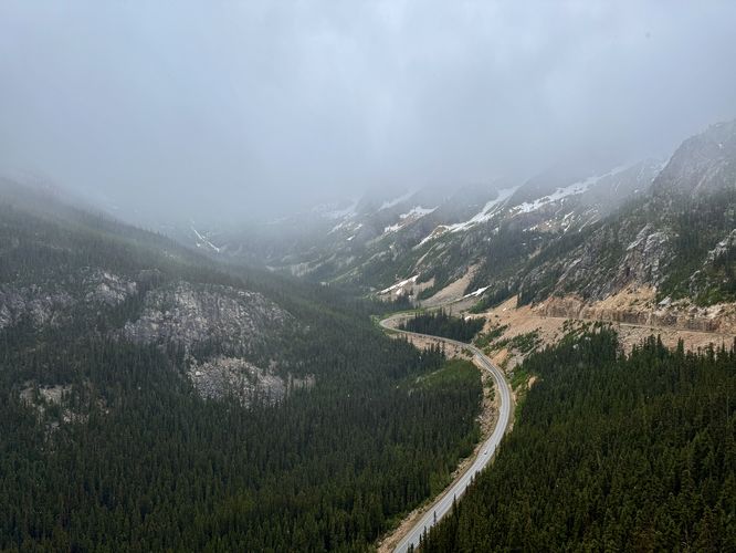
The Washington Pass Overlook at Okanogan-Wenatchee National Forest near Winthrop, Washington is an easy 0.2-mile loop trail that features panoramic views of the alpine mountains that surround Washington Pass.

Explore the Washington Pass Overlook

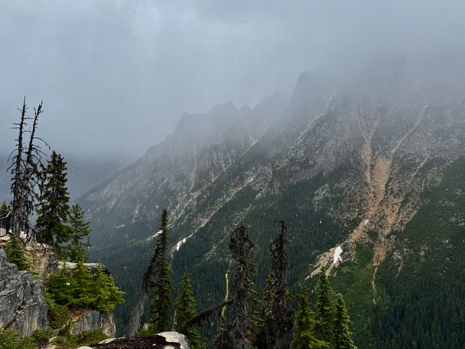
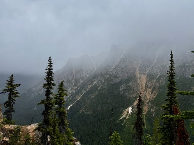
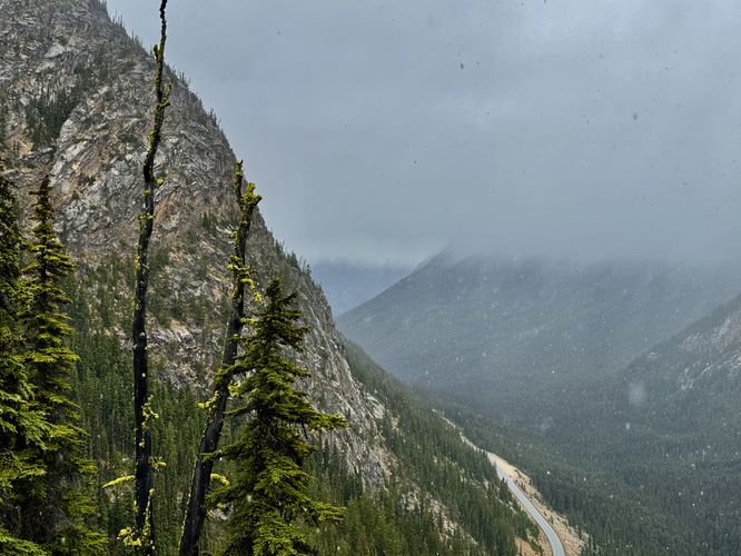
This very short but scenic trail begins just off of the North Cascades Highway along NF500. At the trailhead, you'll find an information kiosk where you can learn more about Washington Pass and also choose which direction of the loop you want to take first. This route follows the southern side of the loop where the trail follows a paved path to reach the southern viewpoint. Reaching the overlook, you'll be standing at least 500-feet above the North Cascades Highway with panoramic views of the alpine landscape that comprises the pass. Following the trail north, it leads to more views of Washington Pass — mostly to the east back toward Winthrop. The easterly views provide more sweeping vistas of rugged and steep alpine peaks. Take the staircase up to the last viewpoint area where you'll find evidence of wildfire with dead evergreens, covered in vibrant-green mosses. Of course, from the third overlook are more alpine views of Washington Pass. From the third overlook, the universally-accessible, paved path begins once more and leads back to parking.

Semi-Universal Access

This trail should be considered semi-universally accessible. From the parking lot out to the lower viewpoint (south side) is about 90% accessible and follows a paved path. At the main overlook, however, the terrain switches from a manicured paved path to lumpy bedrock. The north side of the trail is also universally-accessible, but leads to a staircase that sits adjacent to another viewpoint. The section of trail that connects both viewpoints is not accessible.

Parking & Fees

Hikers will find a large parking lot at the coordinates provided, located along NF500. The lot is large enough to fit a few dozen vehicles as of June 2025. There's a day-use fee which can be paid online with information found at the trailhead, however, there's no cell service. If you have an Annual National Parks Pass, you can leave it on your dashboard instead of paying the day-use fee.

Pets

Dogs are allowed only if leashed and must be cleaned up after.

Warning

Steep cliffs: This trail leads out to an overlook area with sheer drop-offs. Always stay on-trail and stay behind the fence at all times for your own safety.

Cougars: This area is cougar territory and as such, you must be mindful of their potential presence. It's best to hike in a group of two or more and keep small children close at all times. Note that cougar attacks on humans is rare and even more-rare are fatal cougar attacks.
Explore 15 trails near Winthrop, WA

Know Before You Go

  • Offers easy, 0.2-mile paved loop with panoramic alpine views of Washington Pass, accessible to most.
  • Requires a day-use fee (or National Parks Pass) for parking at the large lot along NF500 with no cell service.
  • Demands caution due to steep cliffs and potential cougar presence; keep dogs leashed and children close.
Interactive topographic map for Washington Pass Overlook located in Winthrop, WA. Click the "View Map" button to load GPS coordinates and trail markers.
Get directions
Distance
0.2 mi
Difficulty
Easy
Type
Loop
Est. Time
15 min
Elev. Gain
58'
Rating
4.0
Added
June 20, 2025
Updated
July 16, 2025

Weather Forecast

Loading...
Total Change
53'
Ascent
58'
Descent
58'
Loading...

Download the GPX Data for Offline Use

Supporters get exclusive access to download trail routes to the MyHikes app for offline use. Stay prepared on your adventure, even without an internet connection! Become a Supporter today to unlock this feature and hike with confidence.

Download Washington Pass Overlook GPX Data to the MyHikes Mobile App

Features

Vista / Lookout Point
Dogs

Points of interest

  1. Parking

    48.526324, -120.649619
  2. Main Trailhead

    48.526243, -120.649091
  3. Cloudy view of the North Cascades Highway and alpine slopes

    48.525822, -120.647317
    Cloudy view of the North Cascades Highway and alpine slopes
  4. Sweeping alpine views from the overlook

    48.525867, -120.647217
    Sweeping alpine views from the overlook

Safety information

For your own safety: plan ahead, let someone know where you'll be, and hike at your own risk.

Hazards

Rockfalls, Ledges, or Scrambles

Availability

All seasons

Surface type

Universal Access

Trip Reports (Reviews)

Rated 4.0 out of 5 based on 1 rating.

Ready to help fellow hikers? Add a trip report to share your experience and provide valuable insights for other hikers!

0.2 miles / 0.3 km
June 20, 2025
Hiking
No community routes found. To add your own hike as a Community Route for this Trail guide, leave a Trip Report with an attached GPX file.

Popular categories

Scenic mountain view representing vista trails
Vista trails
Scenic gorge of cascades representing waterfall trails
Waterfall hikes
Rugged mountain terrain representing summit trails
Summit trails
Scenic mountain view representing dog-friendly trails
Dog-friendly
Scenic campsite with a view representing camping trails
Camping trails
Appalachian Trail logo representing A.T. hikes
A.T. hikes

You May Also Like

Glacier's Going-to-the-Sun Road - Discover the breathtaking beauty of Glacier National Park along the iconic Going-to-the-Sun Road. From stunning roadside stops to picturesque waterfalls and vistas, this engineering marvel offers endless opportunities for exploration.
Explore

Glacier's Going-to-the-Sun Road

Discover the breathtaking beauty of Glacier National Park along the iconic Going-to-the-Sun Road. From stunning roadside stops to picturesque waterfalls and vistas, this engineering marvel offers endless opportunities for exploration.

Read
Colorado's Million Dollar Highway - Plan a day's drive adventure along the iconic Million Dollar Highway in Colorado. Explore the best short trails, roadside stops, waterfalls, vistas, ghost towns, and hot springs within a ~6 hour road trip.
Explore

Colorado's Million Dollar Highway

Plan a day's drive adventure along the iconic Million Dollar Highway in Colorado. Explore the best short trails, roadside stops, waterfalls, vistas, ghost towns, and hot springs within a ~6 hour road trip.

Read
🍪 We use cookies to learn about site usage and to serve map tiles. You may block cookies manually in the browser. By continuing you agree. Learn more