The Waihou Spring Trail at the Waihou Spring Forest Reserve in Makawao, Hawaii (Maui) is a moderate 1.7-mile out-and-back hike (with a loop) that leads to a rocky cliff that features a natural spring.
Hike Description
This hike begins at the main trailhead for the Waihou Spring Trail and follows the trail as it leads through a pine forest. Along the way, hikers will spot make-shift bushcraft shelters (note that camping is not allowed), which were likely built by locals. The trail quickly comes to a "junction" located around a bend, with a sign stating "private property" - continue down the hill to stay on the public Waihou Spring Trail.
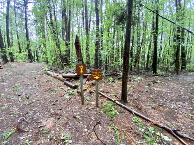
Loop Junction - Mile 0.35
Around mile 0.35, hikers will reach a junction with the loop portion of this hike. This recording heads right first, taking the loop in a counter-clockwise direction.
Waihou Spring / Overlook Spur - Mile 0.43
Around mile 0.43, hikers will reach another trail junction on the right-hand side of the loop. This spur trail leads the hiker to an "overlook" and the Waihou Spring. Hikers will follow this spur trail for 0.25-miles before reaching a steep mountain hollow. At the edge of the flatter terrain, hikers will find a switchback trail that leads down into the steep mountain hollow and then leads over to the Waihou Spring. Note that this GPS recording does not connect to the Waihou Spring; however, the spring is located not much further than 0.2-miles down the switchbacks. I turned around at the first switchback due to hiking alone without an SOS device - as the signage states that wet, saturated ground, can give-way at any time. Despite having extensive steep mountain and canyon hiking experience, hiking alone, in the rain, while the mountain was completely soaking wet, felt too dangerous to hike down switchbacks for a photo of the Waihou Spring, so I turned back. Notes on the "overlook" - there was not much of an overlook located at the start of the switchbacks, but there was a very small opening in the trees that looks at a neighboring mountain slope. Since I did not hike to the spring, it's possible there's another overlook, but my assumption was that this "overlook" was likely grown-in and does not really exist anymore.
Hiking the Loop
After checking out the Waihou Spring, or simply hiking the spur trail out-and-back to the loop again, hikers will want to complete the loop to see the rest of the trail. The loop, from the Waihou Spring spur, heads uphill through more pine forest, passing more bushcraft shelters, before connecting back once again. The terrain isn't very steep, but can be very slick, slippery, and muddy during or after rainfall.
After completing the loop, hikers will take the same trail they hiked in on from the road back to parking.
Eucalyptus
This trail passes through an area where groves of eucalyptus trees grow far off in the distance, but their fragrant scent fills the air the entire time, making for a very relaxing hike.
Parking
Hikers will find a very large parking lot at the coordinates provided. It's large enough to fit over a dozen vehicles.
Pets
Dogs are allowed only if leashed and cleaned-up after.
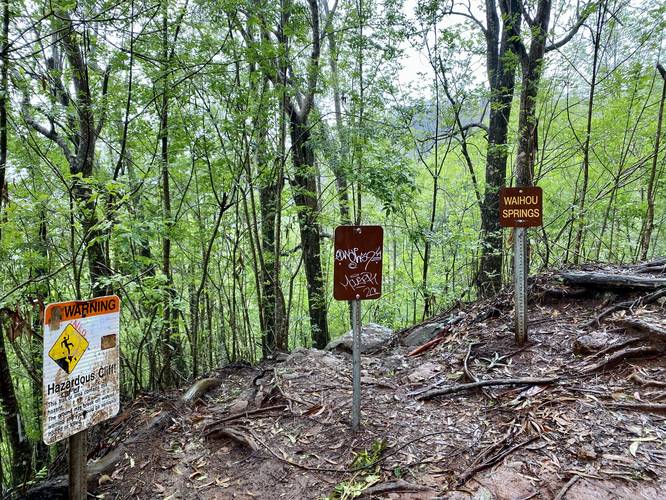
Warning
Steep terrain / landslides: The Waihou Spring is located down in a mountain hollow that requires hiking down switchbacks to reach. While the switchbacks themselves are not dangerous, the steep mountain terrain that they sit on can be. During periods of heavy rainfall, the ground becomes saturated and thus, can give-way at any time without warning. Due to this, landslide or falling accidents can happen here. It might be best to avoid the steep terrain during periods of heavy rainfall or if it's raining while you're on the trail.
Slippery terrain: During periods of heavy rain or after it just rained, this trail can be somewhat of a muddy mess. While it's not a popular trail and there are very few ruts, hikers will likely slip and slide around as you hike through, just because the trail's substrate is mostly just dirt, with some roots here and there.
Respecting the Land
Hawaiian land is considered sacred to native Hawaiians and many locals, so please stay on-trail, take nothing but photos, and leave nothing but footprints. Respect the locals - don't stay for long and have a backup hike planned in case the parking lot is full.
Hike Description
This hike begins at the main trailhead for the Waihou Spring Trail and follows the trail as it leads through a pine forest. Along the way, hikers will spot make-shift bushcraft shelters (note that camping is not allowed), which were likely built by locals. The trail quickly comes to a "junction" located around a bend, with a sign stating "private property" - continue down the hill to stay on the public Waihou Spring Trail.
Loop Junction - Mile 0.35
Around mile 0.35, hikers will reach a junction with the loop portion of this hike. This recording heads right first, taking the loop in a counter-clockwise direction.
Waihou Spring / Overlook Spur - Mile 0.43
Around mile 0.43, hikers will reach another trail junction on the right-hand side of the loop. This spur trail leads the hiker to an "overlook" and the Waihou Spring. Hikers will follow this spur trail for 0.25-miles before reaching a steep mountain hollow. At the edge of the flatter terrain, hikers will find a switchback trail that leads down into the steep mountain hollow and then leads over to the Waihou Spring. Note that this GPS recording does not connect to the Waihou Spring; however, the spring is located not much further than 0.2-miles down the switchbacks. I turned around at the first switchback due to hiking alone without an SOS device - as the signage states that wet, saturated ground, can give-way at any time. Despite having extensive steep mountain and canyon hiking experience, hiking alone, in the rain, while the mountain was completely soaking wet, felt too dangerous to hike down switchbacks for a photo of the Waihou Spring, so I turned back. Notes on the "overlook" - there was not much of an overlook located at the start of the switchbacks, but there was a very small opening in the trees that looks at a neighboring mountain slope. Since I did not hike to the spring, it's possible there's another overlook, but my assumption was that this "overlook" was likely grown-in and does not really exist anymore.
Hiking the Loop
After checking out the Waihou Spring, or simply hiking the spur trail out-and-back to the loop again, hikers will want to complete the loop to see the rest of the trail. The loop, from the Waihou Spring spur, heads uphill through more pine forest, passing more bushcraft shelters, before connecting back once again. The terrain isn't very steep, but can be very slick, slippery, and muddy during or after rainfall.
After completing the loop, hikers will take the same trail they hiked in on from the road back to parking.
Eucalyptus
This trail passes through an area where groves of eucalyptus trees grow far off in the distance, but their fragrant scent fills the air the entire time, making for a very relaxing hike.
Parking
Hikers will find a very large parking lot at the coordinates provided. It's large enough to fit over a dozen vehicles.
Pets
Dogs are allowed only if leashed and cleaned-up after.
Warning
Steep terrain / landslides: The Waihou Spring is located down in a mountain hollow that requires hiking down switchbacks to reach. While the switchbacks themselves are not dangerous, the steep mountain terrain that they sit on can be. During periods of heavy rainfall, the ground becomes saturated and thus, can give-way at any time without warning. Due to this, landslide or falling accidents can happen here. It might be best to avoid the steep terrain during periods of heavy rainfall or if it's raining while you're on the trail.
Slippery terrain: During periods of heavy rain or after it just rained, this trail can be somewhat of a muddy mess. While it's not a popular trail and there are very few ruts, hikers will likely slip and slide around as you hike through, just because the trail's substrate is mostly just dirt, with some roots here and there.
Respecting the Land
Hawaiian land is considered sacred to native Hawaiians and many locals, so please stay on-trail, take nothing but photos, and leave nothing but footprints. Respect the locals - don't stay for long and have a backup hike planned in case the parking lot is full.