Loading...

❄️ WINTER SALE! 50% OFF on Supporter Accounts — now through January 31st. Unlock a full year of exclusive website & app perks. Learn More.

Upper Hawksbill Trail

Directions
Map
Pictures
Download Upper Hawksbill Trail GPX Data to the MyHikes Mobile App
Distance:
2.2 Miles / 3.5 km
Type:
Out-and-Back
Difficulty:
Easy
Time to Hike:
1 hour, ~6 minutes
Features:
Surface Type:
Dirt
Park:
Shenandoah National Park
Town:
Luray, Virginia
Get Directions:
38.543765, -78.39297
Added:
September 11, 2025
Updated:
January 02, 2026
Guide by:
Copy Trail Link Hiking this trail? Send a friend or family member a link to this trail guide for your own safety. Hike at your own risk (disclaimer)
Loading...
Loading...
481'

Total Change
523'

Ascent
562'

Descent

Download the GPX Data for Offline Use

Supporters get exclusive access to download trail routes to the MyHikes app for offline use. Stay prepared on your adventure, even without an internet connection! Become a Supporter today to unlock this feature and hike with confidence.

Download Upper Hawksbill Trail GPX Data to the MyHikes Mobile App

Know Before You Go

  • The Upper Hawksbill Trail is a manageable 2.27-mile out-and-back hike rated as easy, featuring a gravel path that leads to an observation platform with unique mountain-identifying plaques and panoramic valley views.
  • Located at the Upper Hawksbill Trailhead on Skyline Drive, the park is cashless as of 2025. Be prepared to pay entry fees ($15–$30) via credit, debit, or mobile payment, or use a valid National Park pass as of 2025.
  • Pets are welcome on a 6-foot leash, but camping and campfires are strictly prohibited at the summit. While the Byrds Nest 2 Shelter offers a picnic spot, there are no restrooms or trash bins at the trailhead, so you must pack out all trash.

Upper Hawksbill Trail

Trail names: Upper Hawksbill Trail

Location: Upper Hawksbill Trailhead, Skyline Drive, Shenandoah Valley National Park, VA

Permitted uses: Hiking, Nature Study, there is a picnic table at the Byrds Nest 2 Shelter but no trash bins. Pack out all the trash. Foraging small amounts of fruits,mushrooms and nuts for personal use are allowed. For more information please follow the link below:

https://www.nps.gov/shen/learn/management/collecting-plants.htm

Prohibited uses: The taking of plants, animals or cultural artifacts is illegal. Hunting is prohibited. Feeding wildlife is illegal. Bicycles and all motorized vehicles are limited to paved roads only. Camping is not allowed at the Hawksbill Summit. No camping is allowed within 100 yards of the Shelter or in the area of the Hawksbill Summit above 3600’. The Byrds Nest 2 Shelter is for Day use only. Campfires are prohibited.

Hours: The Shenandoah Valley National Park is always open. However the Skyline Drive,which is the only road through the Park is sometimes closed due to inclement weather.

Fees and Parking: There is a fee to enter the Shenandoah National Park. If you enter on foot, the fee is $15.00 per person. If entering via private vehicle, with up to 4 persons over the age of 16 in the car, the fee is $30.00 per car. Persons who are under the age of 16 are not included in the 4 person limit. Those entering by motorcycle are charged a $25.00 fee. If you are part of a Commercial enterprise, Educational Group or a Non Commercial vehicle with more than 16 persons entering the park, there is a fee schedule on the Parks website with fees ranging from Zero to $200.00 depending on the organization and the amount of people in the vehicle. A more economical way to use the park, especially if you plan to hike more than one day, is to buy an annual pass for $55.00, or if you qualify, a Senior annual pass for $20.00 or a Senior lifetime pass for $80.00. There are several free passes available to Military members, Veterans and Gold Star Family members as well as an Access pass for those with permanent disability, Families with a 4th Grader and Volunteers. Cash is NOT accepted for payment so be prepared with an alternate means of payment: either a Credit, Debit card or Mobile payment. These are the ONLY accepted means of payment as of 7/1/2025 when the park went completely cashless. Children under the age of 16 are free and are not required to have a pass. This trailhead has abundant parking as well as parking reserved for those with disabilities.

Pets: Pets must be on a leash at all times. Leashes must be no longer than 6 feet in length.

Accessibility: This hike was not wheelchair accessible.

Hiker amenities: At this trailhead there is an information Kiosk with a posted map. There were no restrooms or trash bins at this trailhead.

Length and Trail information: This hike was done as an out and back hike and was approximately 2.27 miles long. This hike is considered easy. The hike is blazed with a blue trail marker.

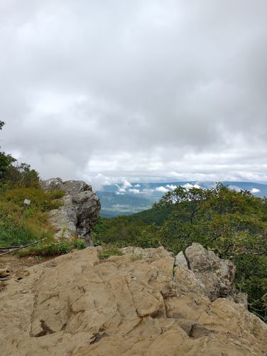
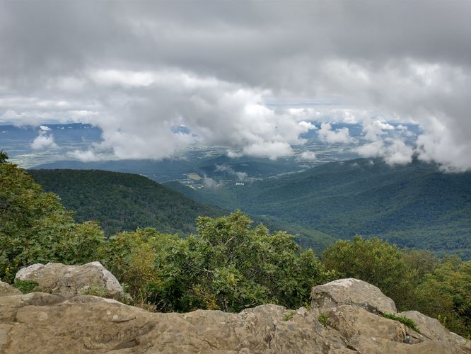
Our goal for this hike was to reach the Byrds Nest 2 Shelter and then hike to the Hawksbill Summit and Observation Point. We stopped to read the information at the Kiosk and then we headed down the flat gravel path to begin our hike. We were hopeful to be able to see some views from the summit as our weather that day had some breaks in the cloud cover. The hike through the forest was filled with stops to identify some of the plants that flank the trail side and to enjoy the birdsong. The hike was well marked and well traveled and the substrate was not difficult to navigate although sections were rocky with a steady incline toward the summit. We were lucky to have some breaks in the cloud cover when we reached the Byrds Nest 2 Shelter and were able to get some lovely views of the valley below. After a short visit at the Shelter, we headed a short distance to the Hawksbill Summit. There is an observation platform with a low rock wall installed for hikers to take a break and take in the views. Installed in the wall are two metal identification plaques. By rotating a dial you can point to a distant mountain and learn the name of the mountain you are looking at. We thought this was a pretty cool feature and would encourage visitors to look for it while you are at the summit.

Explore 90 trails near Luray, VA
  1. Parking

    38.543765, -78.39297
  2. Main Trailhead

    38.543759, -78.393293
  3. Beautiful views

    38.555197, -78.39588
    Beautiful views
  4. Hawksbill Vista

    38.555323, -78.3952
    Hawksbill Vista
No community routes found. To add your own hike as a Community Route for this Trail guide, leave a Trip Report with an attached GPX file.

Hazards

Ticks - Lyme Disease More Info (CDC)
Snakes
Poison Ivy/Oak
Rockfalls / Ledges / or Scrambles

Seasons

All

Blaze Color

Blue

Blaze Dot

Blue

Photo Albums

+ Add Photo Album

Upload your photos from the trail to help others know what to expect.

Trip Reports (Reviews)

Ready to help fellow hikers? Add a trip report to share your experience and provide valuable insights for those planning their next hike. Your review makes the trail better for everyone.

Your opinion matters! Be the first to rate this trail.

Weather Forecast

In Luray, VA

Explore Hiking Trails

You May Also Like

25 Best Day Hikes in North Carolina - Discover the top 25 best day hikes in North Carolina, from breathtaking waterfalls to mountain peaks. Explore hidden gems, scenic views, and trails suitable for all skill levels, perfect for your next outdoor adventure.
Explore

25 Best Day Hikes in North Carolina

Discover the top 25 best day hikes in North Carolina, from breathtaking waterfalls to mountain peaks. Explore hidden gems, scenic views, and trails suitable for all skill levels, perfect for your next outdoor adventure.

Read

Before you boogie...

Find our trail guides useful? Consider becoming a Supporter to unlock perks!

MyHikes is an indie platform that makes exploring public trails easier for everyone. The platform has no investors, no ads, and is owned and operated by one person, Dave Miller. Dave has personally mapped and written over 1,900 trail guides on MyHikes for the public to explore. MyHikes has helped millions outdoor enthusiasts plan their next adventure.

But it takes a lot of time 🕦, money 💰, work, and espresso shots ☕ to run MyHikes, including hiking , mapping , writing , and publishing new trails with high-quality (accurate) information... along with software engineering (coding) the platform like building new features, website and mobile app development (iOS and Android), site maintainance . and much much more.

Supporters unlock website and mobile app perks with an annual one-time payment of $25 (you renew) 😎👍. Or you can simply make a Donation of your choice. Otherwise, you can support us by telling your friends about MyHikes - both quick and free 🎉

Admin avatar

Dave Miller
MyHikes Founder
🍪 We use cookies to learn about site usage, performance, and to serve map tiles. You may block cookies manually in the browser. By continuing to use MyHikes, you agree. Learn more